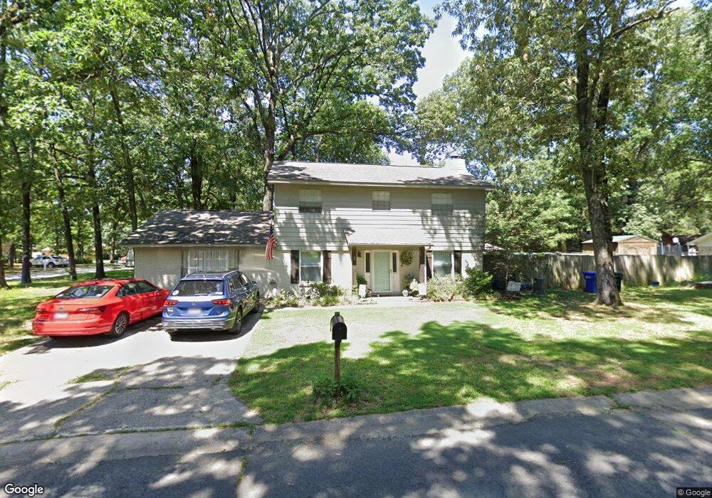
5 Forrest Ln Conway, AR 72034
Downtown Conway NeighborhoodEstimated Value: $290,271 - $337,000
Studio
2
Baths
2,304
Sq Ft
$138/Sq Ft
Est. Value
About This Home
This home is located at 5 Forrest Ln, Conway, AR 72034 and is currently estimated at $318,318, approximately $138 per square foot. 5 Forrest Ln is a home located in Faulkner County with nearby schools including Julia Lee Moore Elementary School, Conway Junior High School, and Conway High School.
Ownership History
Date
Name
Owned For
Owner Type
Purchase Details
Closed on
Oct 6, 2020
Sold by
Reeves Marcus L and Reeves Kimberly A
Bought by
Brown Lori Adell
Current Estimated Value
Home Financials for this Owner
Home Financials are based on the most recent Mortgage that was taken out on this home.
Original Mortgage
$229,330
Outstanding Balance
$203,515
Interest Rate
2.9%
Mortgage Type
New Conventional
Estimated Equity
$114,803
Purchase Details
Closed on
Sep 10, 2003
Bought by
Reeves
Create a Home Valuation Report for This Property
The Home Valuation Report is an in-depth analysis detailing your home's value as well as a comparison with similar homes in the area
Home Values in the Area
Average Home Value in this Area
Purchase History
| Date | Buyer | Sale Price | Title Company |
|---|---|---|---|
| Brown Lori Adell | $241,400 | Faulkner County Title Co | |
| Reeves | $121,000 | -- |
Source: Public Records
Mortgage History
| Date | Status | Borrower | Loan Amount |
|---|---|---|---|
| Open | Brown Lori Adell | $229,330 |
Source: Public Records
Tax History
| Year | Tax Paid | Tax Assessment Tax Assessment Total Assessment is a certain percentage of the fair market value that is determined by local assessors to be the total taxable value of land and additions on the property. | Land | Improvement |
|---|---|---|---|---|
| 2025 | $2,228 | $49,420 | $3,600 | $45,820 |
| 2024 | $2,127 | $49,420 | $3,600 | $45,820 |
| 2023 | $2,026 | $40,030 | $3,600 | $36,430 |
| 2022 | $1,651 | $40,030 | $3,600 | $36,430 |
| 2021 | $1,651 | $40,030 | $3,600 | $36,430 |
| 2020 | $1,001 | $27,200 | $3,600 | $23,600 |
| 2019 | $1,001 | $27,200 | $3,600 | $23,600 |
| 2018 | $1,026 | $27,200 | $3,600 | $23,600 |
| 2017 | $1,023 | $27,200 | $3,600 | $23,600 |
| 2016 | $961 | $25,900 | $3,600 | $22,300 |
| 2015 | $1,248 | $24,670 | $3,600 | $21,070 |
| 2014 | $898 | $24,670 | $3,600 | $21,070 |
Source: Public Records
Map
Nearby Homes
- 10 Forrest Ln
- 2 Pin Oak Dr
- 11 Red Oak Dr
- 41 Tucker Creek Rd
- 1715 Royal Dr
- 2860 Broadmoor Dr
- 1810 Royal Dr
- 15 Covewood Dr
- 2960 Craighead Cir
- 1310 Sunset Dr
- 3 Brandywine Cove
- 2585 Adamsbrooke Dr
- 4 Riviera Dr
- 1930 Columbia Dr
- 1660 Chicot Dr
- 1030 Applewood Dr
- 1945 Columbia Dr
- 1105 Applewood Dr
- 1655 Chicot Dr
- 15 Brierwood Cir
Your Personal Tour Guide
Ask me questions while you tour the home.