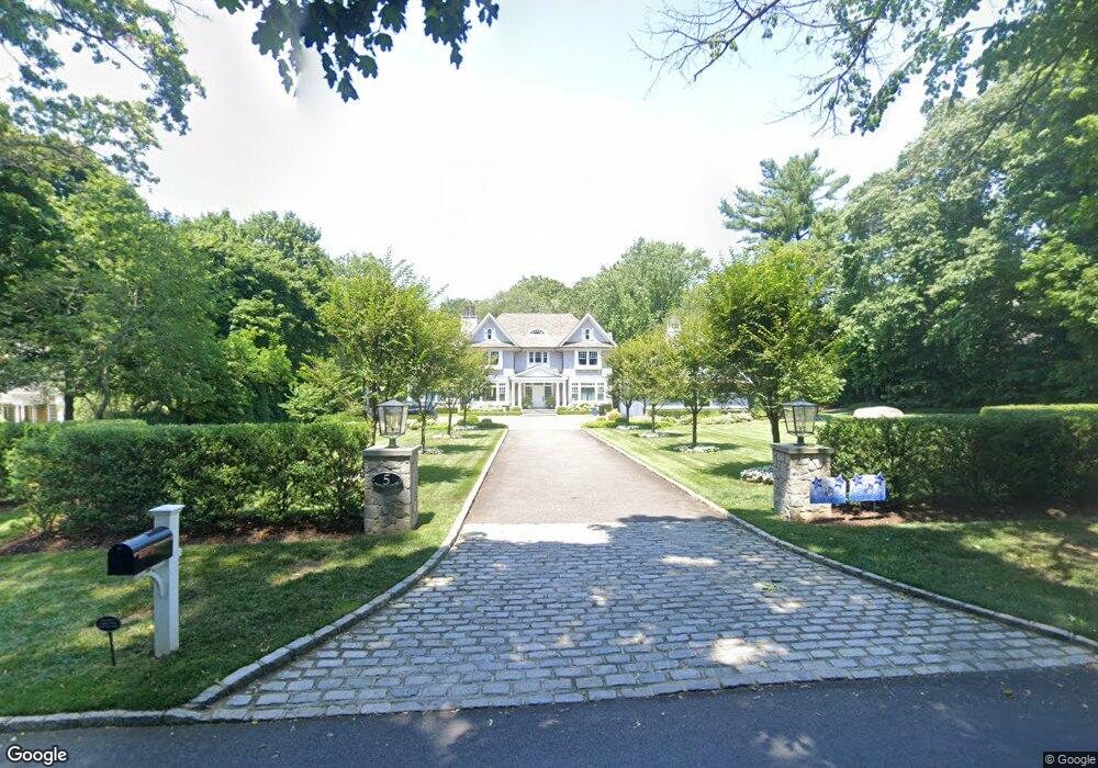
5 Harbor Acres Rd Sands Point, NY 11050
Estimated Value: $3,242,000 - $4,334,354
5
Beds
5
Baths
5,439
Sq Ft
$696/Sq Ft
Est. Value
About This Home
This home is located at 5 Harbor Acres Rd, Sands Point, NY 11050 and is currently estimated at $3,788,177, approximately $696 per square foot. 5 Harbor Acres Rd is a home located in Nassau County with nearby schools including John J. Daly Elementary School, Carrie Palmer Weber Middle School, and Paul D. Schreiber Senior High School.
Ownership History
Date
Name
Owned For
Owner Type
Purchase Details
Closed on
Aug 30, 2017
Sold by
Silbersack John and Silbersack Elionora
Bought by
Goodman Eric and Goodman Gabrielle
Current Estimated Value
Purchase Details
Closed on
Aug 28, 1996
Sold by
Sackman Maryann
Bought by
Schwartz Alan and Schwartz Felice
Home Financials for this Owner
Home Financials are based on the most recent Mortgage that was taken out on this home.
Original Mortgage
$200,000
Interest Rate
8.11%
Mortgage Type
Purchase Money Mortgage
Create a Home Valuation Report for This Property
The Home Valuation Report is an in-depth analysis detailing your home's value as well as a comparison with similar homes in the area
Home Values in the Area
Average Home Value in this Area
Purchase History
| Date | Buyer | Sale Price | Title Company |
|---|---|---|---|
| Goodman Eric | $1,650,000 | Langdon Title Agency Llc | |
| Schwartz Alan | $620,000 | -- |
Source: Public Records
Mortgage History
| Date | Status | Borrower | Loan Amount |
|---|---|---|---|
| Previous Owner | Schwartz Alan | $200,000 |
Source: Public Records
Tax History
| Year | Tax Paid | Tax Assessment Tax Assessment Total Assessment is a certain percentage of the fair market value that is determined by local assessors to be the total taxable value of land and additions on the property. | Land | Improvement |
|---|---|---|---|---|
| 2025 | $38,746 | $2,627 | $1,108 | $1,519 |
| 2024 | $4,446 | $2,800 | $1,181 | $1,619 |
Source: Public Records
Map
Nearby Homes
- 25 Wood Rd
- 12 Hampton Rd
- 1 James Ave
- 11 Delaware Ave
- 1A Orchard Farm Rd
- 80 Longview Rd
- 25 School St
- 10 Hill Rd
- 57 Beacon Hill Rd
- 15 School St
- 24 Orchard Farm Rd
- 33 Avenue B
- 35 Evergreen Ave
- 14 Miro Place
- 23 S Bayles Ave
- 69 Bogart Ave
- 5 Pepperday Ave
- 229 Miro Place Unit 422
- 85 Webster Ave
- 92 Pond View Dr
- 3 Harbor Acres Rd
- 25 Harbor Acres Rd
- 25 Harbor Acres Rd
- 8 Harbor Acres Rd
- 1 Harbor Acres Rd
- 12 Harbor Acres Rd
- 14 South Rd
- 1361 Port Washington Blvd
- 16 South Rd
- 1356 Pt Washington Bl
- 89 Sandy Hollow Rd
- 30 Harbor Acres Rd
- 1346 Port Washington Blvd
- 45 Harbor Acres Rd
- 24 Evelyn Rd
- 0 South Rd
- 1354 Port Washington Blvd
- 22 Evelyn Rd
- 87 Sandy Hollow Rd
- 1356 Port Washington Blvd
Your Personal Tour Guide
Ask me questions while you tour the home.