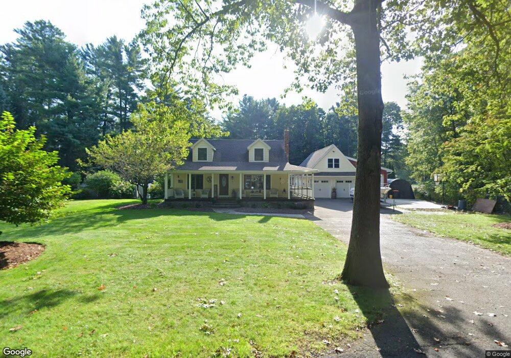
5 Henry Rd South Hadley, MA 01075
Estimated Value: $447,000 - $559,000
3
Beds
2
Baths
1,361
Sq Ft
$382/Sq Ft
Est. Value
About This Home
This home is located at 5 Henry Rd, South Hadley, MA 01075 and is currently estimated at $520,417, approximately $382 per square foot. 5 Henry Rd is a home located in Hampshire County with nearby schools including Plains Elementary School, Mosier Elementary School, and Michael E. Smith Middle School.
Ownership History
Date
Name
Owned For
Owner Type
Purchase Details
Closed on
Feb 9, 2016
Sold by
Nugent Jeffery P
Bought by
Nugent Jeffery P and Nugent Stephanie M
Current Estimated Value
Home Financials for this Owner
Home Financials are based on the most recent Mortgage that was taken out on this home.
Original Mortgage
$236,000
Outstanding Balance
$145,890
Interest Rate
3.98%
Mortgage Type
New Conventional
Estimated Equity
$374,527
Purchase Details
Closed on
Oct 26, 2006
Sold by
Sypek Craig J
Bought by
Nugent Jeffery P
Home Financials for this Owner
Home Financials are based on the most recent Mortgage that was taken out on this home.
Original Mortgage
$212,000
Interest Rate
6.48%
Mortgage Type
Purchase Money Mortgage
Purchase Details
Closed on
Oct 30, 2001
Sold by
Consolini Kelly Ann and Consolini Michael J
Bought by
Sypek Craig J
Create a Home Valuation Report for This Property
The Home Valuation Report is an in-depth analysis detailing your home's value as well as a comparison with similar homes in the area
Home Values in the Area
Average Home Value in this Area
Purchase History
| Date | Buyer | Sale Price | Title Company |
|---|---|---|---|
| Nugent Jeffery P | -- | -- | |
| Nugent Jeffery P | $265,000 | -- | |
| Sypek Craig J | $167,900 | -- |
Source: Public Records
Mortgage History
| Date | Status | Borrower | Loan Amount |
|---|---|---|---|
| Open | Nugent Jeffery P | $236,000 | |
| Previous Owner | Sypek Craig J | $259,868 | |
| Previous Owner | Nugent Jeffery P | $212,000 | |
| Previous Owner | Sypek Craig J | $233,000 | |
| Previous Owner | Sypek Craig J | $25,000 |
Source: Public Records
Tax History Compared to Growth
Tax History
| Year | Tax Paid | Tax Assessment Tax Assessment Total Assessment is a certain percentage of the fair market value that is determined by local assessors to be the total taxable value of land and additions on the property. | Land | Improvement |
|---|---|---|---|---|
| 2025 | $7,881 | $494,700 | $122,400 | $372,300 |
| 2024 | $7,609 | $457,000 | $114,200 | $342,800 |
| 2023 | $7,020 | $400,000 | $103,600 | $296,400 |
| 2022 | $6,425 | $347,700 | $103,600 | $244,100 |
| 2021 | $6,360 | $326,800 | $96,600 | $230,200 |
| 2020 | $5,840 | $292,900 | $96,600 | $196,300 |
| 2019 | $5,723 | $284,000 | $92,500 | $191,500 |
| 2018 | $5,517 | $276,800 | $89,700 | $187,100 |
| 2017 | $4,988 | $247,900 | $89,700 | $158,200 |
| 2016 | $4,895 | $246,600 | $89,700 | $156,900 |
| 2015 | $4,554 | $235,000 | $86,800 | $148,200 |
Source: Public Records
Map
Nearby Homes
- 25 Noel St
- 34 Hildreth Ave
- 63 Washington Ave
- 19 Hildreth Ave
- 30 Yale St
- 540 Granby Rd Unit 62
- 540 Granby Rd Unit 72A
- 540 Granby Rd Unit 109
- 30 Pine Grove Dr
- 0 Granby Rd
- 586 Granby Rd
- 73 Pine Grove Dr
- 200 East St
- 318 Newton St
- 133 Granby Rd
- 85 Fairview St
- 45 Pine St
- 50 Pine St
- 15 Stanton Ave
- 108 College St