M
Seller's Agent in 2021
Meg Bodnar
Tea Lane Associates


Estimated Value: $3,262,000 - $3,699,000
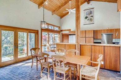
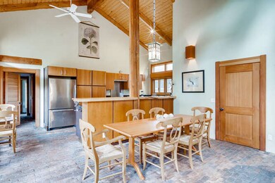
This architectural three-bedroom home is natural and soulful. Surrounded by Japanese landscape and pathways, the thoughtful design features many unique features indoors and out. The kitchen, dining and living rooms comprise a lovely greatroom which is bright and open with high ceilings and windows all around, creating a connection to the outdoor gardens. The wood ceilings in the two main floor bedrooms are intricate weavings of beams and fine craftsmanship. The master bathroom features a custom woodwork and soaking tub. The study provides separate space and is surrounded by beautiful built-in bookshelves and niches. This house must be experienced. ALSO, ownership in the beautiful and serene North Shore Fishing Association beach on the Vineyard Sound in Aquinnah is available with this purchase for $135,000.
Last Agent to Sell the Property
Meg Bodnar
Tea Lane Associates Listed on: 11/13/2020
Last Buyer's Agent
Ana Martins Jorge
Wallace & Co. Sotheby's
| Date | Buyer | Sale Price | Title Company |
|---|---|---|---|
| Mellin Reimer | $1,450,000 | None Available | |
| Norfleet Barbara P | $1,326,000 | -- |
| Date | Status | Borrower | Loan Amount |
|---|---|---|---|
| Previous Owner | Norfleet Barbara P | $100,000 | |
| Previous Owner | Norfleet Barbara P | $75,000 |
| Date | Event | Price | List to Sale | Price per Sq Ft |
|---|---|---|---|---|
| 01/11/2021 01/11/21 | Sold | $1,450,000 | 0.0% | $508 / Sq Ft |
| 11/16/2020 11/16/20 | Pending | -- | -- | -- |
| 11/13/2020 11/13/20 | For Sale | $1,450,000 | -- | $508 / Sq Ft |
| Year | Tax Paid | Tax Assessment Tax Assessment Total Assessment is a certain percentage of the fair market value that is determined by local assessors to be the total taxable value of land and additions on the property. | Land | Improvement |
|---|---|---|---|---|
| 2025 | $7,341 | $3,262,600 | $873,200 | $2,389,400 |
| 2024 | $6,469 | $3,051,300 | $759,300 | $2,292,000 |
| 2023 | $6,300 | $2,395,600 | $584,000 | $1,811,600 |
| 2022 | $6,004 | $2,129,000 | $584,000 | $1,545,000 |
| 2021 | $3,958 | $1,360,200 | $584,000 | $776,200 |
| 2020 | $3,842 | $1,343,500 | $572,600 | $770,900 |
| 2019 | $3,699 | $1,284,500 | $572,600 | $711,900 |
| 2018 | $3,532 | $1,284,500 | $572,600 | $711,900 |
| 2017 | $3,426 | $1,278,400 | $572,600 | $705,800 |
| 2016 | $3,450 | $1,273,200 | $572,600 | $700,600 |
| 2015 | $3,370 | $1,281,400 | $572,600 | $708,800 |
| 2014 | $3,669 | $1,479,400 | $602,000 | $877,400 |
M
Seller's Agent in 2021
Meg Bodnar
Tea Lane Associates
A
Buyer's Agent in 2021
Ana Martins Jorge
Wallace & Co. Sotheby's
Source: LINK (Vineyard)
MLS Number: 37512
APN: CHIL-000014-000000-000021