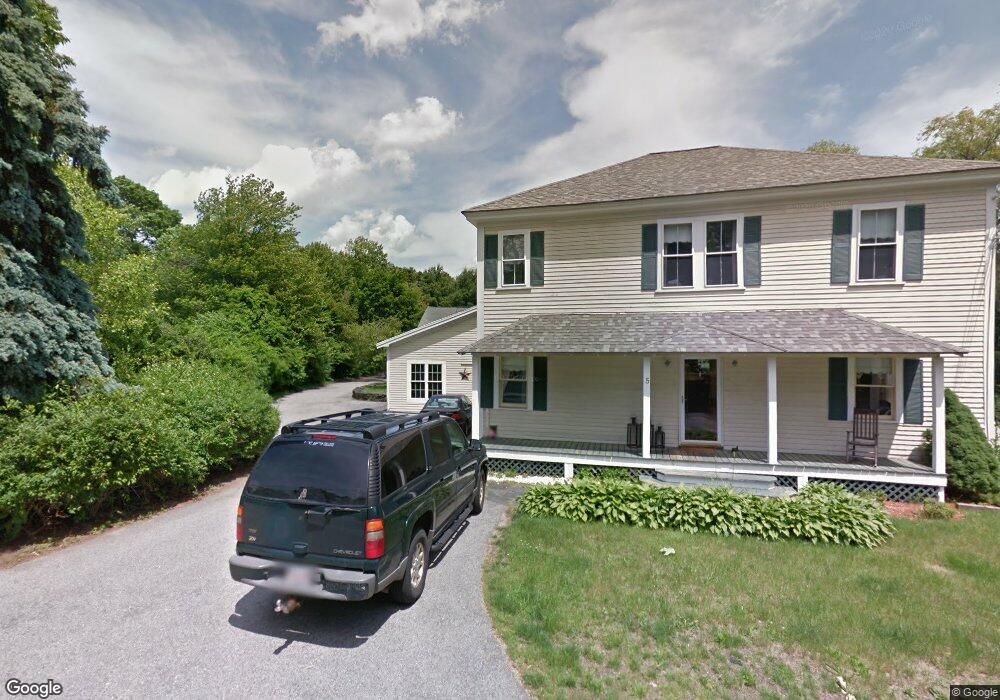
5 North St Andover, MA 01810
Shawsheen Heights NeighborhoodEstimated Value: $1,022,000 - $1,514,000
4
Beds
2
Baths
4,440
Sq Ft
$288/Sq Ft
Est. Value
About This Home
This home is located at 5 North St, Andover, MA 01810 and is currently estimated at $1,276,947, approximately $287 per square foot. 5 North St is a home located in Essex County with nearby schools including High Plain Elementary School, Wood Hill Middle School, and Andover High School.
Ownership History
Date
Name
Owned For
Owner Type
Purchase Details
Closed on
Dec 24, 1996
Sold by
Andover Bank
Bought by
Riendeau Steven R
Current Estimated Value
Home Financials for this Owner
Home Financials are based on the most recent Mortgage that was taken out on this home.
Original Mortgage
$152,000
Outstanding Balance
$16,311
Interest Rate
7.62%
Mortgage Type
Purchase Money Mortgage
Estimated Equity
$1,260,636
Purchase Details
Closed on
May 19, 1987
Sold by
Salyers Gaylord M
Bought by
Bedard Gary A
Create a Home Valuation Report for This Property
The Home Valuation Report is an in-depth analysis detailing your home's value as well as a comparison with similar homes in the area
Home Values in the Area
Average Home Value in this Area
Purchase History
| Date | Buyer | Sale Price | Title Company |
|---|---|---|---|
| Riendeau Steven R | $190,000 | -- | |
| Riendeau Steven R | $190,000 | -- | |
| Bedard Gary A | $210,000 | -- |
Source: Public Records
Mortgage History
| Date | Status | Borrower | Loan Amount |
|---|---|---|---|
| Open | Bedard Gary A | $100,000 | |
| Closed | Bedard Gary A | $15,000 | |
| Open | Bedard Gary A | $152,000 |
Source: Public Records
Tax History
| Year | Tax Paid | Tax Assessment Tax Assessment Total Assessment is a certain percentage of the fair market value that is determined by local assessors to be the total taxable value of land and additions on the property. | Land | Improvement |
|---|---|---|---|---|
| 2024 | $14,297 | $1,110,000 | $425,700 | $684,300 |
| 2023 | $13,808 | $1,010,800 | $394,400 | $616,400 |
| 2022 | $12,994 | $890,000 | $334,300 | $555,700 |
| 2021 | $12,441 | $813,700 | $303,800 | $509,900 |
| 2020 | $11,952 | $796,300 | $296,400 | $499,900 |
| 2019 | $11,524 | $754,700 | $266,800 | $487,900 |
| 2018 | $10,935 | $699,200 | $251,500 | $447,700 |
| 2017 | $10,502 | $691,800 | $246,700 | $445,100 |
| 2016 | $10,281 | $693,700 | $246,700 | $447,000 |
| 2015 | $9,853 | $658,200 | $237,100 | $421,100 |
Source: Public Records
Map
Nearby Homes
- 4 Weeping Willow Dr
- 5 Weeping Willow Dr
- 9 Oakland Rd
- 2 Weeping Willow Dr
- 58 Chandler Rd
- 5 Crestwood Cir
- 2 Boardwalk Dr
- 29 Westchester Dr
- 0
- 11 Swan Ln Unit 11
- 12 Robert Dr Unit 12
- 20 Robert Dr Unit 20
- 35 Adams St
- 25 Clubview Dr Unit 25
- 21 Clubview Dr Unit 21
- 750 Brookside Dr Unit G
- 1 Lancaster Place
- 31 Crenshaw Ln Unit 31
- 37 Crenshaw Ln Unit 37
- 40 Chandler Cir
- 1 North St
- 6 North St
- 81 Chandler Rd
- 9 North St
- 8 North St
- 7 North St
- 85 Chandler Rd
- 11 North St
- 213 Greenwood Rd
- 78 Chandler Rd
- 215 Greenwood Rd
- 217 Greenwood Rd
- 211 Greenwood Rd
- 72 Chandler Rd
- 550 Mount Vernon St
- 84 Chandler Rd
- 516 Mount Vernon St
- 87 Chandler Rd
- 209 Greenwood Rd
- 520 Mount Vernon St
Your Personal Tour Guide
Ask me questions while you tour the home.