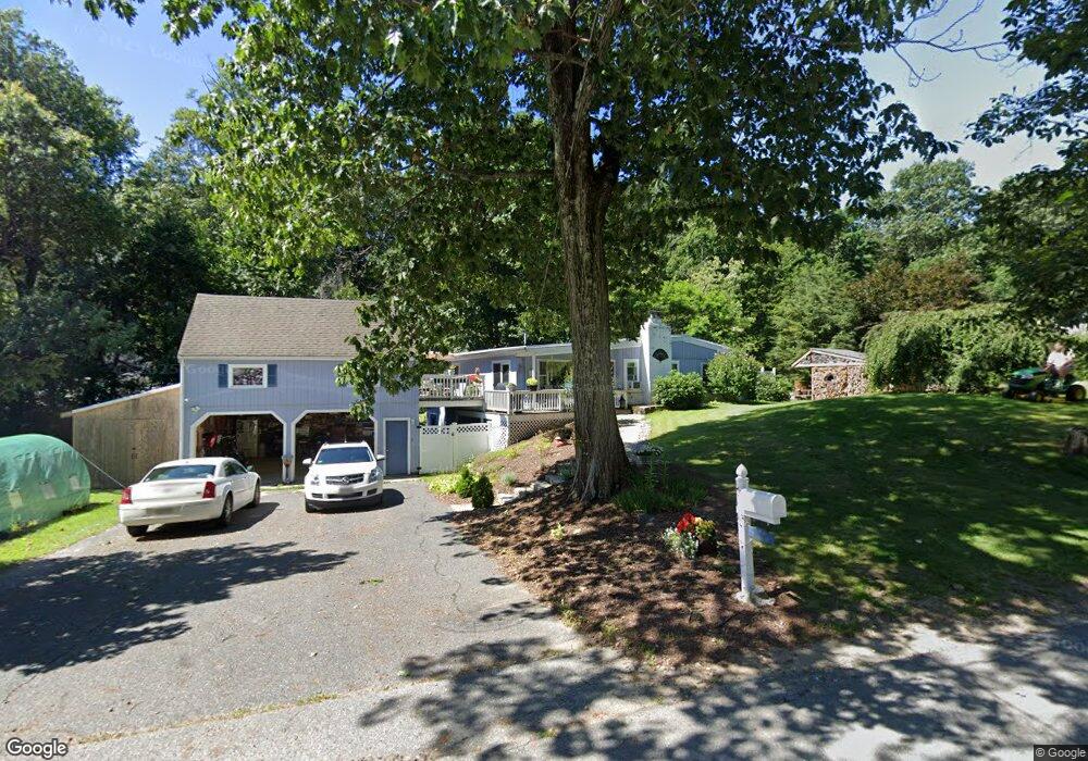
5 Osgood Ave West Boylston, MA 01583
Estimated Value: $434,863 - $500,000
3
Beds
1
Bath
1,174
Sq Ft
$401/Sq Ft
Est. Value
About This Home
This home is located at 5 Osgood Ave, West Boylston, MA 01583 and is currently estimated at $470,716, approximately $400 per square foot. 5 Osgood Ave is a home located in Worcester County with nearby schools including Major Edwards Elementary School, West Boylston Junior/Senior High School, and Abby Kelley Foster Charter Public School.
Ownership History
Date
Name
Owned For
Owner Type
Purchase Details
Closed on
Dec 13, 1996
Sold by
Bousquet Charles L and Bousquet Theresa
Bought by
Hopkins Dana and Vaudreuil Charlene
Current Estimated Value
Home Financials for this Owner
Home Financials are based on the most recent Mortgage that was taken out on this home.
Original Mortgage
$101,520
Interest Rate
7.75%
Mortgage Type
Purchase Money Mortgage
Create a Home Valuation Report for This Property
The Home Valuation Report is an in-depth analysis detailing your home's value as well as a comparison with similar homes in the area
Home Values in the Area
Average Home Value in this Area
Purchase History
| Date | Buyer | Sale Price | Title Company |
|---|---|---|---|
| Hopkins Dana | $112,800 | -- |
Source: Public Records
Mortgage History
| Date | Status | Borrower | Loan Amount |
|---|---|---|---|
| Open | Hopkins Dana | $107,000 | |
| Closed | Hopkins Dana | $30,000 | |
| Closed | Hopkins Dana | $100,000 | |
| Closed | Hopkins Dana | $101,520 |
Source: Public Records
Tax History Compared to Growth
Tax History
| Year | Tax Paid | Tax Assessment Tax Assessment Total Assessment is a certain percentage of the fair market value that is determined by local assessors to be the total taxable value of land and additions on the property. | Land | Improvement |
|---|---|---|---|---|
| 2025 | $58 | $416,600 | $105,100 | $311,500 |
| 2024 | $5,670 | $383,600 | $105,100 | $278,500 |
| 2023 | $5,486 | $352,100 | $104,200 | $247,900 |
| 2022 | $5,203 | $294,300 | $104,200 | $190,100 |
| 2021 | $5,062 | $274,200 | $100,400 | $173,800 |
| 2020 | $4,885 | $262,900 | $100,400 | $162,500 |
| 2019 | $4,599 | $244,000 | $100,400 | $143,600 |
| 2018 | $4,405 | $235,300 | $100,400 | $134,900 |
| 2017 | $3,950 | $210,100 | $100,400 | $109,700 |
| 2016 | $3,823 | $207,200 | $93,600 | $113,600 |
| 2015 | $3,747 | $204,300 | $92,600 | $111,700 |
Source: Public Records
Map
Nearby Homes
- 22 Danielles Way
- 26 Danielles Way
- 31 Danielles Way
- 9 Idalla Ave
- 535 Prospect St
- 23 Orono St
- 87 Malden St
- 93 Winfield Rd
- 15 Cumberland St
- 29 Isleboro St
- 12 Dixfield Rd
- 29 Glenwood St
- 33 Isleboro St
- 83 Stoneleigh Rd
- 1110 W Boylston St Unit A
- 10 Beale St
- 21 Wyoming Dr
- 1 Juneberry Ln Unit 82
- 12 Birchbrush Ln
- 740 Burncoat St Unit B