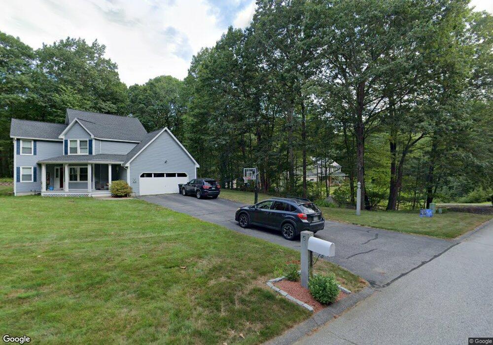
5 Parker Dr Merrimack, NH 03054
Estimated Value: $614,110 - $683,000
3
Beds
3
Baths
1,800
Sq Ft
$356/Sq Ft
Est. Value
About This Home
This home is located at 5 Parker Dr, Merrimack, NH 03054 and is currently estimated at $641,028, approximately $356 per square foot. 5 Parker Dr is a home located in Hillsborough County with nearby schools including James Mastricola Elementary School, Merrimack Middle School, and James Mastricola Upper Elementary School.
Ownership History
Date
Name
Owned For
Owner Type
Purchase Details
Closed on
Sep 26, 2011
Sold by
Desmarais Virginia I
Bought by
Burns Timothy R and Burns Audra M
Current Estimated Value
Home Financials for this Owner
Home Financials are based on the most recent Mortgage that was taken out on this home.
Original Mortgage
$233,700
Interest Rate
4.33%
Mortgage Type
Purchase Money Mortgage
Create a Home Valuation Report for This Property
The Home Valuation Report is an in-depth analysis detailing your home's value as well as a comparison with similar homes in the area
Home Values in the Area
Average Home Value in this Area
Purchase History
Date | Buyer | Sale Price | Title Company |
---|---|---|---|
Burns Timothy R | $246,000 | -- |
Source: Public Records
Mortgage History
Date | Status | Borrower | Loan Amount |
---|---|---|---|
Open | Burns Timothy R | $33,000 | |
Open | Burns Timothy R | $225,000 | |
Closed | Burns Timothy R | $233,700 |
Source: Public Records
Tax History Compared to Growth
Tax History
Year | Tax Paid | Tax Assessment Tax Assessment Total Assessment is a certain percentage of the fair market value that is determined by local assessors to be the total taxable value of land and additions on the property. | Land | Improvement |
---|---|---|---|---|
2024 | $8,859 | $428,200 | $248,200 | $180,000 |
2023 | $8,328 | $428,200 | $248,200 | $180,000 |
2022 | $7,442 | $428,200 | $248,200 | $180,000 |
2021 | $7,352 | $428,200 | $248,200 | $180,000 |
2020 | $7,569 | $314,600 | $176,200 | $138,400 |
2019 | $7,502 | $310,900 | $176,200 | $134,700 |
2018 | $7,499 | $310,900 | $176,200 | $134,700 |
2017 | $7,266 | $310,900 | $176,200 | $134,700 |
2016 | $7,085 | $310,900 | $176,200 | $134,700 |
2015 | $7,231 | $292,500 | $164,200 | $128,300 |
2014 | $7,046 | $292,500 | $164,200 | $128,300 |
2013 | $6,755 | $282,500 | $164,200 | $118,300 |
Source: Public Records
Map
Nearby Homes
- 24 Longa Rd
- 54-A Parkhurst Rd
- 11 Clark Island Rd
- 4 Norton St
- 70 Broadway
- 24 Profile Dr
- 14 Captain Bannon Cir
- 19 Captain Bannon Cir
- 8 Bowman Ct
- 9 Carriage Ln
- 32 Valleyview Dr
- 25 Fells Dr
- 13 Holly Hill Dr
- 3 Powderhouse Rd
- 20 Holly Hill Dr
- 19 Pinnacle Rd
- 19 Turkey Hill Rd
- 10 Greenbriar Ln
- 60 Colonel Daniels Dr
- 28 Old Manchester Rd
- 5 Parker Dr
- 3 Parker Dr
- 4 Parker Dr
- 256 Baboosic Lake Rd
- 1 Parker Dr
- 2 Parker Dr
- 248 Baboosic Lake Rd
- 6 Parker Dr
- 253 Baboosic Lake Rd
- 255 Baboosic Lake Rd
- 7 Parker Dr
- 7 Linden Way
- 21 Parker Dr
- 5 Linden Way
- 19 Parker Dr
- 15 Parker Dr
- 257 Baboosic Lake Rd
- 251 Baboosic Lake Rd
- 260 Baboosic Lake Rd
- 8 Parker Dr