
Seller's Agent in 2025
Susan Santoro
William Pitt
(203) 605-5297
10 in this area
287 Total Sales
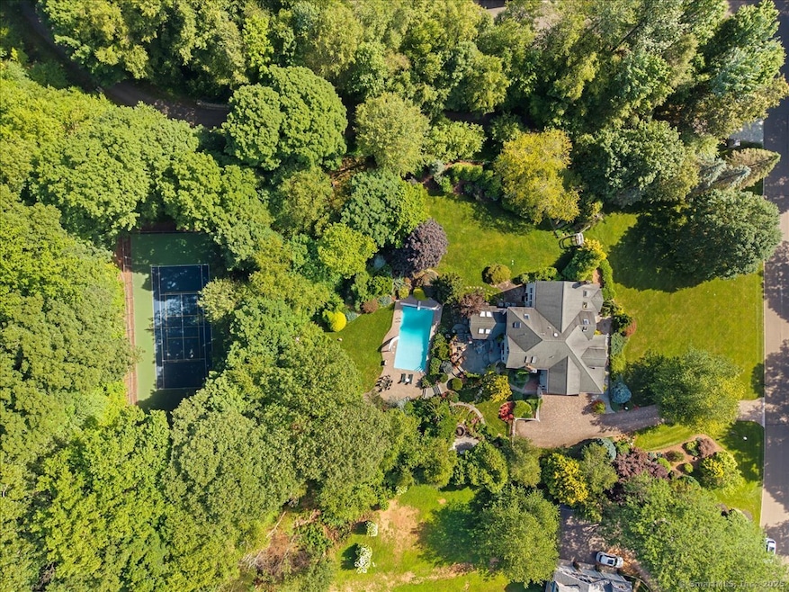
Welcome to a spectacular retreat in Southern Cheshire's coveted Mountaincrest neighborhood. This stunning 4-bedroom home is filled with natural light, thanks to oversized windows & skylights throughout. A dramatic two-story foyer leads into a spacious living room with cathedral ceilings and a cozy fireplace, setting the tone for a warm, inviting layout. The living room flows beautifully into a banquet size dining room wrapped in walls of glass that overlook lush, professionally landscaped gardens. The new kitchen is a chef's dream-designed with custom cabinetry, a large pantry, high-end appliances, & a huge center island. A spacious eating area opens right into the family room, where you'll find custom built-ins and a second fireplace. Just off the kitchen is a heated sunroom-an ideal flex space for a home office, den, or peaceful solarium. Upstairs are 4 large bedrooms and updated bathrooms, including a primary suite with incredible closet space and a spa-like bath. The newly refinished walk-out lower level offers a large playroom, gym & rec space. Step out onto the oversized deck and your very own private resort awaits-nearly 2 acres of manicured grounds with a heated swimming pool, fabulous cabana & a tennis court that's also lined for pickleball. 3 car garage opens to an enormous mud room/laundry. Lots of upgrades. Generator. This is a rare chance to live in a peaceful, luxury setting with top-tier amenities. A home like this doesn't come around often.
Last Agent to Sell the Property
William Pitt Sotheby's Int'l Brokerage Phone: (203) 605-5297 License #RES.0601790 Listed on: 08/12/2025
| Date | Type | Sale Price | Title Company |
|---|---|---|---|
| Warranty Deed | $1,500,000 | -- | |
| Warranty Deed | $575,000 | -- | |
| Warranty Deed | $575,000 | -- | |
| Deed | $612,000 | -- |
| Date | Status | Loan Amount | Loan Type |
|---|---|---|---|
| Previous Owner | $400,000 | No Value Available | |
| Previous Owner | $301,000 | No Value Available | |
| Previous Owner | $354,433 | No Value Available |
| Date | Event | Price | List to Sale | Price per Sq Ft |
|---|---|---|---|---|
| 10/23/2025 10/23/25 | Sold | $1,500,000 | 0.0% | $301 / Sq Ft |
| 10/08/2025 10/08/25 | Pending | -- | -- | -- |
| 08/12/2025 08/12/25 | For Sale | $1,500,000 | -- | $301 / Sq Ft |
| Year | Tax Paid | Tax Assessment Tax Assessment Total Assessment is a certain percentage of the fair market value that is determined by local assessors to be the total taxable value of land and additions on the property. | Land | Improvement |
|---|---|---|---|---|
| 2025 | $19,513 | $656,110 | $169,470 | $486,640 |
| 2024 | $18,017 | $656,110 | $169,470 | $486,640 |
| 2023 | $17,755 | $505,990 | $169,480 | $336,510 |
| 2022 | $17,366 | $505,990 | $169,480 | $336,510 |
| 2021 | $17,062 | $505,990 | $169,480 | $336,510 |
| 2020 | $16,809 | $505,990 | $169,480 | $336,510 |
| 2019 | $16,809 | $505,990 | $169,480 | $336,510 |
| 2018 | $17,482 | $535,930 | $189,090 | $346,840 |
| 2017 | $17,118 | $535,930 | $189,090 | $346,840 |
| 2016 | $16,448 | $535,930 | $189,090 | $346,840 |
| 2015 | $16,448 | $535,930 | $189,090 | $346,840 |
| 2014 | $16,212 | $535,930 | $189,090 | $346,840 |
Seller's Agent in 2025
Susan Santoro
William Pitt
(203) 605-5297
10 in this area
287 Total Sales
Buyer's Agent in 2025
Lauren Freedman
Coldwell Banker Realty
(203) 889-8336
14 in this area
705 Total Sales
Source: SmartMLS
MLS Number: 24117056
APN: CHES-000083-000072
Disclaimer: Certain information contained herein is derived from information provided by parties other than Homes.com. All information provided is deemed reliable, but is not guaranteed to be accurate and should be independently verified.
![]() IDX information is provided exclusively for personal, non-commercial use, and may not be used for any purpose other than to identify prospective properties consumers may be interested in purchasing. Information is deemed reliable but not guaranteed.
IDX information is provided exclusively for personal, non-commercial use, and may not be used for any purpose other than to identify prospective properties consumers may be interested in purchasing. Information is deemed reliable but not guaranteed.
Ask me questions while you tour the home.