Estimated Value: $565,000 - $639,000
3
Beds
4
Baths
2,486
Sq Ft
$244/Sq Ft
Est. Value
About This Home
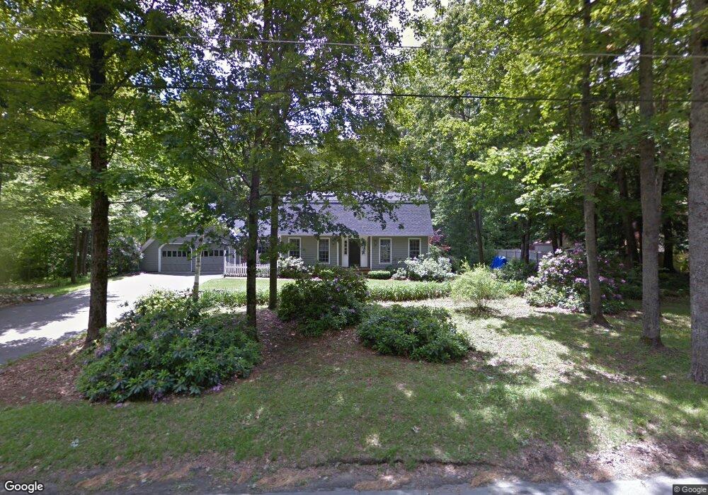
This home is located at 50 Blackberry Ln, Keene, NH 03431 and is currently estimated at $606,190, approximately $243 per square foot. 50 Blackberry Ln is a home with nearby schools including Mount Gilead Elementary School, Symonds Elementary School, and Keene Middle School.
Ownership History
Date
Name
Owned For
Owner Type
Purchase Details
Closed on
Sep 23, 1999
Sold by
Rebillard Raoul and Rebillard Priscilla K
Bought by
Landry David R and Landry Martha M
Current Estimated Value
Home Financials for this Owner
Home Financials are based on the most recent Mortgage that was taken out on this home.
Original Mortgage
$146,500
Outstanding Balance
$44,366
Interest Rate
8.1%
Estimated Equity
$561,824
Purchase Details
Closed on
Sep 16, 1997
Sold by
Metzgar James R and Metzgar Marie E
Bought by
Rebillard Raoul and Rebillard Priscilla
Home Financials for this Owner
Home Financials are based on the most recent Mortgage that was taken out on this home.
Original Mortgage
$90,000
Interest Rate
7.31%
Purchase Details
Closed on
Apr 30, 1996
Sold by
Finkel Peter W and Finkel Gail K
Bought by
Metzgar James R and Metzgar Marie E
Home Financials for this Owner
Home Financials are based on the most recent Mortgage that was taken out on this home.
Original Mortgage
$148,000
Interest Rate
7.81%
Create a Home Valuation Report for This Property
The Home Valuation Report is an in-depth analysis detailing your home's value as well as a comparison with similar homes in the area
Home Values in the Area
Average Home Value in this Area
Purchase History
| Date | Buyer | Sale Price | Title Company |
|---|---|---|---|
| Landry David R | $216,500 | -- | |
| Rebillard Raoul | $185,500 | -- | |
| Metzgar James R | $185,000 | -- |
Source: Public Records
Mortgage History
| Date | Status | Borrower | Loan Amount |
|---|---|---|---|
| Open | Metzgar James R | $146,500 | |
| Previous Owner | Metzgar James R | $90,000 | |
| Previous Owner | Metzgar James R | $148,000 |
Source: Public Records
Tax History Compared to Growth
Tax History
| Year | Tax Paid | Tax Assessment Tax Assessment Total Assessment is a certain percentage of the fair market value that is determined by local assessors to be the total taxable value of land and additions on the property. | Land | Improvement |
|---|---|---|---|---|
| 2024 | $12,954 | $391,700 | $60,600 | $331,100 |
| 2023 | $12,491 | $391,700 | $60,600 | $331,100 |
| 2022 | $12,154 | $391,700 | $60,600 | $331,100 |
| 2021 | $12,252 | $391,700 | $60,600 | $331,100 |
| 2020 | $419 | $329,700 | $70,500 | $259,200 |
| 2019 | $385 | $329,700 | $70,500 | $259,200 |
| 2018 | $467 | $329,700 | $70,500 | $259,200 |
| 2017 | $12,271 | $329,700 | $70,500 | $259,200 |
| 2016 | $438 | $329,700 | $70,500 | $259,200 |
| 2015 | $13,055 | $379,400 | $71,500 | $307,900 |
Source: Public Records
Map
Nearby Homes
- 110 Arch St Unit 27
- 110 Arch St Unit 42
- 15 Stearns Rd
- 38 Stonehouse Ln Unit A
- 28 Stonehouse Ln
- 18 Stanton Ct
- 8 Tanner Rd
- 23 Base Hill Rd
- 257 Park Ave
- 45 Blossom St
- 7 Newman St
- 106 Pako Ave
- 11 Nut Hatch Ln
- 17 Blue Jay Ct
- 25 Schult St
- 115 Liberty Ln
- 64 Old Walpole Rd
- 184 Kennedy Dr
- 792 Court St Unit A
- 798 Court St Unit G