Estimated Value: $736,000 - $997,000
4
Beds
3
Baths
2,453
Sq Ft
$336/Sq Ft
Est. Value
About This Home
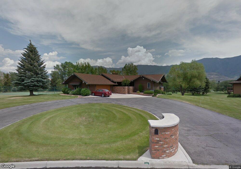
This home is located at 50 Burning Tree Ln, Butte, MT 59701 and is currently estimated at $823,289, approximately $335 per square foot. 50 Burning Tree Ln is a home located in Silver Bow County with nearby schools including Hillcrest Elementary School, East Middle School, and Butte High School.
Ownership History
Date
Name
Owned For
Owner Type
Purchase Details
Closed on
Apr 25, 2025
Sold by
Burke Partners Lp
Bought by
Bristol Trevor and Bristol Francis
Current Estimated Value
Purchase Details
Closed on
Apr 1, 2025
Sold by
Bristol Trevor and Bristol Francis
Bought by
Bristol Trevor and Bristol Francis
Purchase Details
Closed on
Aug 24, 2023
Sold by
Nancy M Burke Disclaimer Trust
Bought by
Bristol Trevor and Bristol Francis
Home Financials for this Owner
Home Financials are based on the most recent Mortgage that was taken out on this home.
Original Mortgage
$565,000
Interest Rate
6.96%
Mortgage Type
New Conventional
Create a Home Valuation Report for This Property
The Home Valuation Report is an in-depth analysis detailing your home's value as well as a comparison with similar homes in the area
Purchase History
| Date | Buyer | Sale Price | Title Company |
|---|---|---|---|
| Bristol Trevor | -- | None Listed On Document | |
| Bristol Trevor | -- | None Listed On Document | |
| Bristol Trevor | -- | None Listed On Document |
Source: Public Records
Mortgage History
| Date | Status | Borrower | Loan Amount |
|---|---|---|---|
| Previous Owner | Bristol Trevor | $565,000 |
Source: Public Records
Tax History
| Year | Tax Paid | Tax Assessment Tax Assessment Total Assessment is a certain percentage of the fair market value that is determined by local assessors to be the total taxable value of land and additions on the property. | Land | Improvement |
|---|---|---|---|---|
| 2025 | $5,939 | $783,600 | $0 | $0 |
| 2024 | $6,885 | $743,612 | $0 | $0 |
| 2023 | $7,519 | $795,402 | $0 | $0 |
| 2022 | $6,170 | $520,400 | $0 | $0 |
| 2021 | $5,794 | $520,400 | $0 | $0 |
| 2020 | $6,150 | $488,500 | $0 | $0 |
| 2019 | $6,160 | $488,500 | $0 | $0 |
| 2018 | $5,986 | $486,600 | $0 | $0 |
| 2017 | $4,937 | $486,600 | $0 | $0 |
| 2016 | $5,311 | $461,600 | $0 | $0 |
| 2015 | $4,900 | $461,600 | $0 | $0 |
| 2014 | $3,570 | $155,184 | $0 | $0 |
Source: Public Records
Map
Nearby Homes
- 3127 Keokuk St
- 3003 Meadowlark Ln
- 3002 Meadowlark Ln
- 3313 Monroe Ave
- 3300 Hannibal St
- 105 Country Club Ln
- 3320 Busch St
- 1830 Holmes Ave
- 3101 Phillips St
- 2821 Edwards St
- Tbd Harrison Ave
- 3440 Burlington St
- 3250 Paxson Ave
- 3127 Edwards St
- 2809 State St
- 3001 Busch St
- 3101 Paxson Ave
- 2925 Bayard St
- 4107 Trenton St
- 1839 Longfellow St
- 40 Burning Tree Ln
- 45 Burning Tree Ln
- 30 Burning Tree Ln
- 35 Burning Tree Ln
- 25 Burning Tree Ln
- 20 Burning Tree Ln
- 75 Burning Tree Ln
- 21 Burning Tree Ln
- 72 Burning Tree Ln
- 79 Burning Tree Ln
- 81 Burning Tree Ln
- 83 Burning Tree Ln
- 15 Burning Tree Ln
- 85 Burning Tree Ln
- 76 Burning Tree Ln
- 78 Burning Tree Ln
- TBD Burning Tree Ln
- 80 Burning Tree Ln
- 13 Burning Tree Ln
- 6 Burning Tree Ln