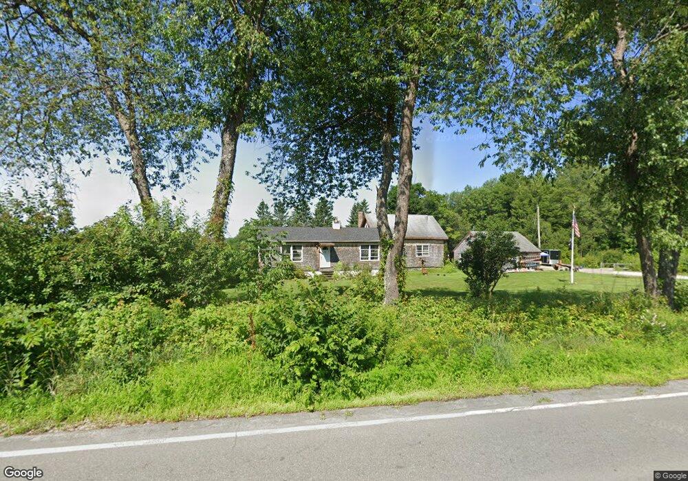
50 North Rd Jefferson, NH 03583
Estimated Value: $466,396 - $659,000
4
Beds
2
Baths
2,230
Sq Ft
$237/Sq Ft
Est. Value
About This Home
This home is located at 50 North Rd, Jefferson, NH 03583 and is currently estimated at $529,599, approximately $237 per square foot. 50 North Rd is a home located in Coos County with nearby schools including Jefferson Elementary School and White Mountains Regional High School.
Ownership History
Date
Name
Owned For
Owner Type
Purchase Details
Closed on
Dec 26, 2024
Sold by
Wasuta Gregory
Bought by
Wasuta William E and Wasuta Gregory
Current Estimated Value
Purchase Details
Closed on
Oct 19, 2023
Sold by
Marshall
Bought by
Wasuta William E and Wasuta Gregory R
Purchase Details
Closed on
Jun 10, 2022
Sold by
Matsubara Dale E
Bought by
Wasuta Gregory
Purchase Details
Closed on
Sep 15, 2015
Sold by
Wasuta William E and Wasuta Linda A
Bought by
Wasuta William E
Create a Home Valuation Report for This Property
The Home Valuation Report is an in-depth analysis detailing your home's value as well as a comparison with similar homes in the area
Home Values in the Area
Average Home Value in this Area
Purchase History
| Date | Buyer | Sale Price | Title Company |
|---|---|---|---|
| Wasuta William E | -- | None Available | |
| Wasuta William E | -- | None Available | |
| Wasuta William E | $110,000 | None Available | |
| Wasuta William E | $110,000 | None Available | |
| Wasuta Gregory | $42,000 | None Available | |
| Wasuta Gregory | $42,000 | None Available | |
| Wasuta William E | -- | -- | |
| Wasuta William E | -- | -- |
Source: Public Records
Mortgage History
| Date | Status | Borrower | Loan Amount |
|---|---|---|---|
| Previous Owner | Wasuta William E | $70,000 |
Source: Public Records
Tax History Compared to Growth
Tax History
| Year | Tax Paid | Tax Assessment Tax Assessment Total Assessment is a certain percentage of the fair market value that is determined by local assessors to be the total taxable value of land and additions on the property. | Land | Improvement |
|---|---|---|---|---|
| 2023 | $3,986 | $222,200 | $47,800 | $174,400 |
| 2022 | $4,124 | $222,200 | $47,800 | $174,400 |
| 2021 | $3,960 | $222,200 | $47,800 | $174,400 |
| 2020 | $4,091 | $181,400 | $33,100 | $148,300 |
| 2019 | $3,989 | $181,400 | $33,100 | $148,300 |
| 2018 | $3,820 | $181,400 | $33,100 | $148,300 |
| 2017 | $3,746 | $181,400 | $33,100 | $148,300 |
| 2016 | $3,699 | $181,400 | $33,100 | $148,300 |
| 2015 | $3,823 | $187,700 | $33,100 | $154,600 |
| 2014 | $3,864 | $189,700 | $33,100 | $156,600 |
| 2013 | $3,747 | $189,700 | $33,100 | $156,600 |
Source: Public Records
Map
Nearby Homes
- 85 Jason Ave
- 48 Jason Ave
- 97 Jason Ave
- 435 North Rd
- 22 Crystal Ave
- 729 Presidential Hwy
- 86 & 89 Garland Rd
- 0 Garland Rd Unit 38
- 0 Bray Hill Rd Unit 5044055
- 86 & 90 Garland Rd
- 218 Portland St
- Lot 82 Portland St
- Lot 2 Portland St
- 959 Presidential Hwy
- 19 Great Rock Rd
- 98 Rowell Rd
- 140 Middle St
- Lot 26 Hartco Ave
- Lot 21 Hartco Ave
- Lot 11 Hartco Ave