
Seller's Agent in 2025
Donald Exler
Southern Classic Realtors
(678) 702-2247
61 Total Sales
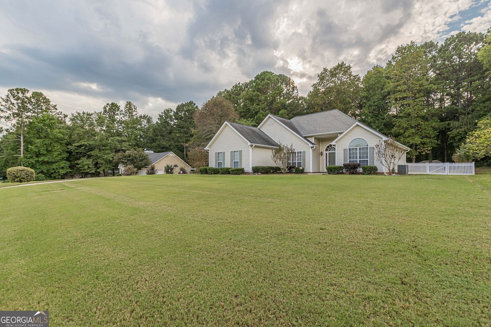
Welcome to 50 Riverside walk - a beautifully maintained home nestled in one of Sharpsburg's most desirable neighborhoods. This spacious residence offers the perfect blend of comfort, style, and convenience, featuring 3 bedrooms and 2 full baths. Step inside to discover a bright, open-concept living area with vaulted ceilings and abundant natural light. The family room flows seamlessly into a well-appointed kitchen boasting stainless steel appliances, ample cabinet space, and a cozy breakfast area. The split-bedroom floor plan offers privacy, with a spacious owner's suite that includes a walk-in closet and en-suite bath with a soaking tub and separate shower. Enjoy peaceful mornings or entertaining evenings on the large back deck overlooking a serene, private backyard. Additional highlights include a two-car garage, separate laundry room, and low-maintenance landscaping. Located just minutes from shopping, dining, top-rated schools, and easy access to I-85 - this home offers both tranquility and convenience. No HOA. Don't miss this opportunity to own a move-in ready gem in the heart of Sharpsburg!
Last Agent to Sell the Property
Southern Classic Realtors License #387530 Listed on: 09/17/2025
| Date | Type | Sale Price | Title Company |
|---|---|---|---|
| Deed | $135,900 | -- | |
| Deed | -- | -- | |
| Deed | -- | -- | |
| Deed | $27,300 | -- | |
| Deed | $1,156,200 | -- |
| Date | Status | Loan Amount | Loan Type |
|---|---|---|---|
| Open | $110,000 | New Conventional |
| Date | Event | Price | List to Sale | Price per Sq Ft |
|---|---|---|---|---|
| 10/17/2025 10/17/25 | Sold | $345,000 | -1.4% | $204 / Sq Ft |
| 10/03/2025 10/03/25 | Pending | -- | -- | -- |
| 09/17/2025 09/17/25 | For Sale | $349,900 | -- | $207 / Sq Ft |
| Year | Tax Paid | Tax Assessment Tax Assessment Total Assessment is a certain percentage of the fair market value that is determined by local assessors to be the total taxable value of land and additions on the property. | Land | Improvement |
|---|---|---|---|---|
| 2025 | $1,118 | $125,772 | $26,000 | $99,772 |
| 2024 | $949 | $120,498 | $26,000 | $94,498 |
| 2023 | $949 | $119,768 | $20,000 | $99,768 |
| 2022 | $787 | $100,890 | $20,000 | $80,890 |
| 2021 | $659 | $81,413 | $16,000 | $65,413 |
| 2020 | $659 | $81,413 | $16,000 | $65,413 |
| 2019 | $635 | $69,136 | $10,000 | $59,136 |
| 2018 | $639 | $69,136 | $10,000 | $59,136 |
| 2017 | $579 | $63,566 | $10,000 | $53,566 |
| 2016 | $626 | $63,566 | $10,000 | $53,566 |
| 2015 | $447 | $54,995 | $10,000 | $44,995 |
| 2014 | $432 | $54,995 | $10,000 | $44,995 |
Seller's Agent in 2025
Donald Exler
Southern Classic Realtors
(678) 702-2247
61 Total Sales
T
Buyer's Agent in 2025
Tyler Christiansen
Southern Classic Realtors
(678) 972-3382
46 Total Sales
Source: Georgia MLS
MLS Number: 10607124
APN: 123-6033-142
Disclaimer: Certain information contained herein is derived from information provided by parties other than Homes.com. All information provided is deemed reliable, but is not guaranteed to be accurate and should be independently verified.
![]() The data relating to real estate for sale on this web site comes in part from the Broker Reciprocity Program of Georgia MLS. Real estate listings held by brokerage firms other than Redfin are marked with the Broker Reciprocity logo and detailed information about them includes the name of the listing brokers. Information deemed reliable but not guaranteed. Copyright 2025 Georgia MLS. All rights reserved.
The data relating to real estate for sale on this web site comes in part from the Broker Reciprocity Program of Georgia MLS. Real estate listings held by brokerage firms other than Redfin are marked with the Broker Reciprocity logo and detailed information about them includes the name of the listing brokers. Information deemed reliable but not guaranteed. Copyright 2025 Georgia MLS. All rights reserved.