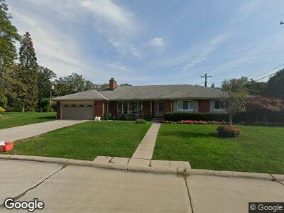
50 Shorecrest Cir Grosse Pointe Shores, MI 48236
Estimated Value: $570,000 - $657,000
--
Bed
--
Bath
2,484
Sq Ft
$243/Sq Ft
Est. Value
About This Home
This home is located at 50 Shorecrest Cir, Grosse Pointe Shores, MI 48236 and is currently estimated at $602,789, approximately $242 per square foot. 50 Shorecrest Cir is a home located in Macomb County with nearby schools including Ferry Elementary School, Parcells Middle School, and Grosse Pointe North High School.
Ownership History
Date
Name
Owned For
Owner Type
Purchase Details
Closed on
Jun 14, 2004
Sold by
Gusmano James J and Gusmano Catherine C
Bought by
James J Gusmano Trust
Current Estimated Value
Purchase Details
Closed on
Jun 9, 2004
Sold by
Hayden Frank K and Hayden Marlene M
Bought by
Gusmano James J and Gusmano Catherine C
Purchase Details
Closed on
Oct 30, 2003
Sold by
Comerica Bank
Bought by
Hayden Frank K and Bolles Nancy R
Purchase Details
Closed on
Jan 6, 1986
Sold by
Hayden Elizabeth M and Hayden Frank Paul
Bought by
Hayden Frank K and Bolles Nancy R
Create a Home Valuation Report for This Property
The Home Valuation Report is an in-depth analysis detailing your home's value as well as a comparison with similar homes in the area
Home Values in the Area
Average Home Value in this Area
Purchase History
| Date | Buyer | Sale Price | Title Company |
|---|---|---|---|
| James J Gusmano Trust | -- | Manzo Title Company | |
| Gusmano James J | $378,000 | First American Title Ins Co | |
| Hayden Frank K | -- | Multiple | |
| Hayden Frank K | -- | Manzo Title Company |
Source: Public Records
Mortgage History
| Date | Status | Borrower | Loan Amount |
|---|---|---|---|
| Open | Gusmano Catherine C | $250,000 |
Source: Public Records
Tax History Compared to Growth
Tax History
| Year | Tax Paid | Tax Assessment Tax Assessment Total Assessment is a certain percentage of the fair market value that is determined by local assessors to be the total taxable value of land and additions on the property. | Land | Improvement |
|---|---|---|---|---|
| 2024 | $6,245 | $314,800 | $0 | $0 |
| 2023 | $5,886 | $276,500 | $0 | $0 |
| 2022 | $5,886 | $266,100 | $0 | $0 |
| 2021 | $6,016 | $262,900 | $0 | $0 |
| 2020 | $0 | $255,800 | $0 | $0 |
| 2019 | $0 | $237,100 | $0 | $0 |
| 2018 | $0 | $216,300 | $0 | $0 |
| 2017 | $0 | $190,240 | $74,000 | $116,240 |
| 2016 | $5,481 | $190,240 | $0 | $0 |
| 2015 | -- | $124,450 | $0 | $0 |
| 2011 | -- | $124,170 | $0 | $0 |
Source: Public Records
Map
Nearby Homes
- 1001 Lake Shore Rd
- 45 Crestwood Dr
- 41 N Duval Rd
- 1010 Lake Shore Rd
- 576 Woods Ln
- 22865 Lakeshore Dr
- 655 Canterbury Rd
- 23165 Westbury St
- 22930 Allen Ct Unit 115
- 22919 Allen Ct Unit 177
- 22953 Allen Rd Unit 361
- 22958 Lee Ct
- 22920 Marter Rd
- 23145 Doremus St
- 23016 California St
- 935 S Brys Dr
- 23018 Englehardt St
- 23013 Lingemann St
- 585 Heritage Place
- 575 Heritage Place
- 50 Shorecrest Cir
- 50 Shorecrest Cir
- 40 Shorecrest Cir
- 999 Lake Shore Rd
- 56 Shorecrest Cir
- 56 Shorecrest Cir
- 1005 Lake Shore Rd
- 40 Shorecrest Cir
- 1005 Lake Shore Rd
- 1005 Lake Shore Rd
- 57 Shorecrest Cir
- 57 Shorecrest Cir
- 999 Lake Shore Rd
- 10 Shorecrest Cir
- 60 Shorecrest Cir
- 60 Shorecrest Cir
- 10 Shorecrest Cir
- 3 Shorecrest Cir
- 1017 Lake Shore Rd
- 1017 Lake Shore Rd