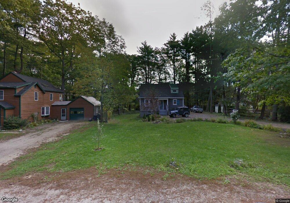
50 Wyman Ave Unit A Kittery, ME 03904
Estimated Value: $471,000 - $608,000
3
Beds
2
Baths
1,543
Sq Ft
$353/Sq Ft
Est. Value
About This Home
This home is located at 50 Wyman Ave Unit A, Kittery, ME 03904 and is currently estimated at $545,052, approximately $353 per square foot. 50 Wyman Ave Unit A is a home located in York County with nearby schools including Horace Mitchell Primary School, Shapleigh School, and Robert W Traip Academy.
Ownership History
Date
Name
Owned For
Owner Type
Purchase Details
Closed on
Jan 30, 2015
Sold by
Betancourt Jose A and Cifuentes Linda N
Bought by
Delaney Mitchell
Current Estimated Value
Home Financials for this Owner
Home Financials are based on the most recent Mortgage that was taken out on this home.
Original Mortgage
$235,554
Outstanding Balance
$179,697
Interest Rate
3.81%
Mortgage Type
FHA
Estimated Equity
$365,355
Purchase Details
Closed on
May 21, 2014
Sold by
Laflamme Richard P and Laflamme Danielle I
Bought by
Betancourt Jose A and Cifuentes Linda N
Create a Home Valuation Report for This Property
The Home Valuation Report is an in-depth analysis detailing your home's value as well as a comparison with similar homes in the area
Home Values in the Area
Average Home Value in this Area
Purchase History
| Date | Buyer | Sale Price | Title Company |
|---|---|---|---|
| Delaney Mitchell | -- | -- | |
| Betancourt Jose A | -- | -- |
Source: Public Records
Mortgage History
| Date | Status | Borrower | Loan Amount |
|---|---|---|---|
| Open | Delaney Mitchell | $235,554 |
Source: Public Records
Tax History Compared to Growth
Tax History
| Year | Tax Paid | Tax Assessment Tax Assessment Total Assessment is a certain percentage of the fair market value that is determined by local assessors to be the total taxable value of land and additions on the property. | Land | Improvement |
|---|---|---|---|---|
| 2024 | $3,943 | $277,700 | $75,000 | $202,700 |
| 2023 | $3,779 | $277,700 | $75,000 | $202,700 |
| 2022 | $3,743 | $277,700 | $75,000 | $202,700 |
| 2021 | $3,610 | $277,700 | $75,000 | $202,700 |
| 2020 | $3,582 | $277,700 | $75,000 | $202,700 |
| 2019 | $4,188 | $240,700 | $68,100 | $172,600 |
| 2018 | $3,867 | $240,700 | $68,100 | $172,600 |
| 2017 | $3,935 | $240,700 | $68,100 | $172,600 |
| 2016 | $3,863 | $240,700 | $68,100 | $172,600 |
| 2015 | $3,778 | $241,100 | $68,100 | $173,000 |
| 2014 | $3,742 | $241,100 | $68,100 | $173,000 |
| 2013 | $3,670 | $241,100 | $68,100 | $173,000 |
Source: Public Records
Map
Nearby Homes
- 12 Gillis Dr Unit 3
- 116 Whipple Rd
- 205 Whipple Rd
- 10-12 Pine St
- 165 Rogers Rd
- 8 Spruce Point Rd
- 299 Haley Rd
- 100 Shepards Cove Rd Unit F204
- 100 Shepards Cove Rd Unit G204
- 8 Water St Unit 2
- 8 Water St Unit 1
- 72 Pepperrell Rd
- 197 State Rd
- 17 Elm Ct
- 15 Atkinson St
- 14 Colonial Ln
- 20 Mendum Ave
- 35 Badgers Island W Unit 203
- 35 Badgers Island W Unit 301
- 35 Badgers Island W Unit 204