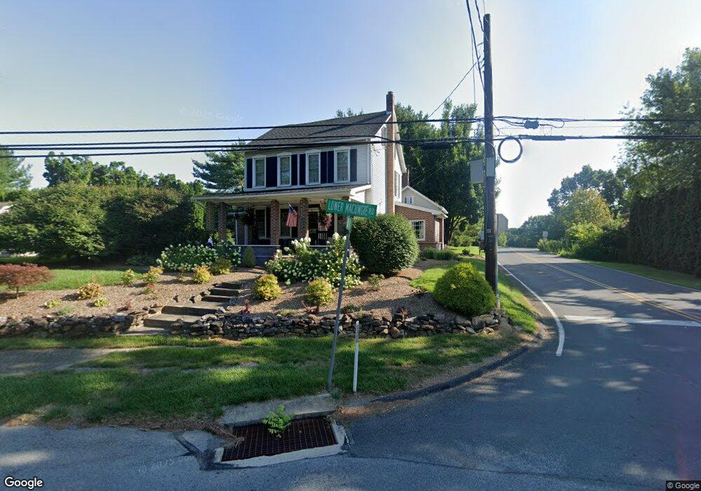
5001 Lower MacUngie Rd Macungie, PA 18062
Estimated Value: $491,841 - $595,000
3
Beds
2
Baths
2,636
Sq Ft
$202/Sq Ft
Est. Value
About This Home
This home is located at 5001 Lower MacUngie Rd, Macungie, PA 18062 and is currently estimated at $533,710, approximately $202 per square foot. 5001 Lower MacUngie Rd is a home located in Lehigh County with nearby schools including Wescosville Elementary School, Lower Macungie Middle School, and Emmaus High School.
Ownership History
Date
Name
Owned For
Owner Type
Purchase Details
Closed on
Jun 19, 2015
Sold by
Davies Clifford and Davies Robin F
Bought by
Bertsch Rodger L and Bertsch Susan L
Current Estimated Value
Home Financials for this Owner
Home Financials are based on the most recent Mortgage that was taken out on this home.
Original Mortgage
$260,000
Outstanding Balance
$201,592
Interest Rate
3.78%
Mortgage Type
New Conventional
Estimated Equity
$332,118
Purchase Details
Closed on
Sep 6, 2006
Sold by
Davies Robin F and Fry Robin A
Bought by
Davies Robin F and Davies Clifford
Purchase Details
Closed on
Sep 20, 1993
Sold by
Fry Robin A
Bought by
Daviesd Robin F
Purchase Details
Closed on
Jul 21, 1986
Bought by
Fry Robin A
Purchase Details
Closed on
Dec 31, 1985
Bought by
Fry Robin A
Create a Home Valuation Report for This Property
The Home Valuation Report is an in-depth analysis detailing your home's value as well as a comparison with similar homes in the area
Home Values in the Area
Average Home Value in this Area
Purchase History
| Date | Buyer | Sale Price | Title Company |
|---|---|---|---|
| Bertsch Rodger L | $325,000 | Penn Title Co | |
| Davies Robin F | -- | None Available | |
| Daviesd Robin F | -- | -- | |
| Fry Robin A | $46,500 | -- | |
| Fry Robin A | $43,000 | -- |
Source: Public Records
Mortgage History
| Date | Status | Borrower | Loan Amount |
|---|---|---|---|
| Open | Bertsch Rodger L | $260,000 |
Source: Public Records
Tax History
| Year | Tax Paid | Tax Assessment Tax Assessment Total Assessment is a certain percentage of the fair market value that is determined by local assessors to be the total taxable value of land and additions on the property. | Land | Improvement |
|---|---|---|---|---|
| 2025 | $5,647 | $221,200 | $57,700 | $163,500 |
| 2024 | $5,464 | $221,200 | $57,700 | $163,500 |
| 2023 | $5,355 | $221,200 | $57,700 | $163,500 |
| 2022 | $5,228 | $221,200 | $163,500 | $57,700 |
| 2021 | $5,117 | $221,200 | $57,700 | $163,500 |
| 2020 | $5,068 | $221,200 | $57,700 | $163,500 |
| 2019 | $4,982 | $221,200 | $57,700 | $163,500 |
| 2018 | $4,916 | $221,200 | $57,700 | $163,500 |
| 2017 | $4,830 | $221,200 | $57,700 | $163,500 |
| 2016 | -- | $221,200 | $57,700 | $163,500 |
| 2015 | -- | $221,200 | $57,700 | $163,500 |
| 2014 | -- | $221,200 | $57,700 | $163,500 |
Source: Public Records
Map
Nearby Homes
- 2621 Saddle Ln Unit 21C
- 4698 Berwyn Ln
- 2173 Brookside Rd
- 2475 Houghton Lean Unit 2
- 2041 Gregory Dr
- 5398 Princeton Rd
- 2153 Isabel Ln
- 2096 Gregory Dr
- 2518 Stanford Cir
- 2560 Gracie Lone
- 5238 Dartmouth Dr
- 5200 Spring Ridge Dr E
- 1385 Brookside Rd
- 5770 Fresh Meadow Dr
- 1850 Briarcliff Terrace
- 1800 Minesite Rd
- 2362 Cross Creek Rd
- 5041 Cypress St
- 2509 Ludwig Ct
- 3045 Sheffield Dr
- 5005 Lower MacUngie Rd
- 2060 Dougherty Cir
- 4915 Lower MacUngie Rd
- 2050 Dougherty Cir
- 4970 Lower MacUngie Rd
- 4913 Lower MacUngie Rd
- 5025 Lower MacUngie Rd
- 4901 Waterford Dr
- 4903 Waterford Dr
- 1975 Fallow Ct
- 1985 Fallow Ct
- 4911 Lower MacUngie Rd
- 4897 Waterford Dr
- 2045 Dougherty Cir
- 2025 Dougherty Cir
- 4902 Waterford Dr
- 1980 Fallow Ct
- 4893 Waterford Dr
- 4978 Bridlepath Dr
Your Personal Tour Guide
Ask me questions while you tour the home.