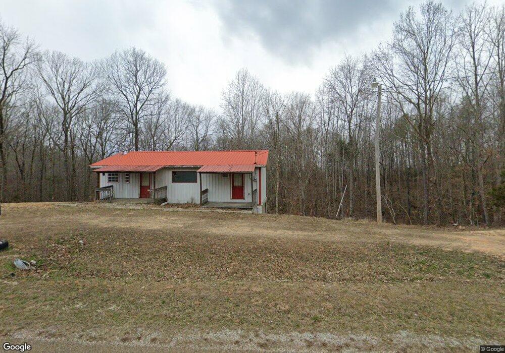
5004 Highway 13 S Linden, TN 37096
Estimated Value: $36,000 - $87,000
1
Bed
2
Baths
1,920
Sq Ft
$32/Sq Ft
Est. Value
About This Home
This home is located at 5004 Highway 13 S, Linden, TN 37096 and is currently estimated at $60,607, approximately $31 per square foot. 5004 Highway 13 S is a home located in Perry County.
Ownership History
Date
Name
Owned For
Owner Type
Purchase Details
Closed on
Oct 8, 2024
Sold by
Patton Jonathon Lee
Bought by
Magnolia Property Holdings Llc
Current Estimated Value
Purchase Details
Closed on
Apr 13, 2023
Sold by
Hanks Edward C
Bought by
Patton Jonathan
Purchase Details
Closed on
Jun 8, 1990
Bought by
Hanks Edward C
Purchase Details
Closed on
Aug 28, 1989
Bought by
Miller Tim J
Create a Home Valuation Report for This Property
The Home Valuation Report is an in-depth analysis detailing your home's value as well as a comparison with similar homes in the area
Home Values in the Area
Average Home Value in this Area
Purchase History
| Date | Buyer | Sale Price | Title Company |
|---|---|---|---|
| Magnolia Property Holdings Llc | $40,000 | None Listed On Document | |
| Patton Jonathan | -- | None Listed On Document | |
| Hanks Edward C | $2,500 | -- | |
| Miller Tim J | $1,800 | -- |
Source: Public Records
Tax History Compared to Growth
Tax History
| Year | Tax Paid | Tax Assessment Tax Assessment Total Assessment is a certain percentage of the fair market value that is determined by local assessors to be the total taxable value of land and additions on the property. | Land | Improvement |
|---|---|---|---|---|
| 2025 | $290 | $12,625 | $0 | $0 |
| 2024 | $290 | $12,625 | $2,450 | $10,175 |
| 2023 | $0 | $12,625 | $2,450 | $10,175 |
| 2022 | $290 | $12,625 | $2,450 | $10,175 |
| 2021 | $290 | $12,625 | $2,450 | $10,175 |
| 2020 | $290 | $12,625 | $2,450 | $10,175 |
| 2019 | $309 | $12,475 | $2,450 | $10,025 |
| 2018 | $309 | $12,475 | $2,450 | $10,025 |
| 2017 | $306 | $12,475 | $2,450 | $10,025 |
| 2016 | $306 | $12,475 | $2,450 | $10,025 |
| 2015 | $300 | $12,475 | $2,450 | $10,025 |
| 2014 | $300 | $12,475 | $2,450 | $10,025 |
| 2013 | $379 | $15,771 | $0 | $0 |
Source: Public Records
Map
Nearby Homes
- 505 Big Buffalo Estates Cir
- 1591 Marsh Creek Rd
- 145 Big Buffalo Estates Cir
- 7468 Old Hohenwald Rd
- 8072 Old Hohenwald Rd
- 5681 Old Hohenwald Rd
- 4439 Old Hohenwald Rd
- 7696 Old Hohenwald Rd
- 6004 Old Hohenwald Rd
- 5608 Old Hohenwald Rd
- 2172 Airport Ridge Rd
- 146 Wyatt Ln
- 2082 Airport Ridge Rd
- 117 Wyatt Ln
- 0 Linda Ln Unit RTC3046693
- 2017 Airport Ridge Rd
- 289 Center Ridge Dr
- 218 Cedar Ave
- 2383 Airport Ridge Rd
- 149 Highland Dr
- 5018 Highway 13 S
- 4921 Highway 13 S
- 5094 Highway 13 S
- 5122 Highway 13 S
- 5195 Highway 13 S
- 4386 Old Highway 13 S
- 189 Kimble Rd
- 4630 Highway 13 S
- 4546 Highway 13 S
- 4546 Highway 13 S
- 1345 Highway 128
- 1345 Highway 128
- 187 Kimble Rd
- 4448 Highway 13 S
- 188 Kimble Rd
- 41 Kimble Rd
- 106 Kimble Rd
- 607 Kimble Rd
- 35 Kimble Rd
- 4223 Old Highway 13 S