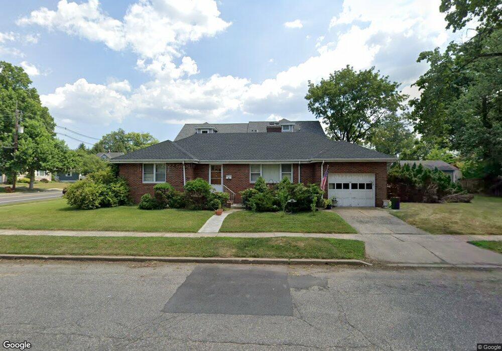
501 2nd St Dunellen, NJ 08812
Estimated Value: $457,000 - $497,000
2
Beds
2
Baths
1,320
Sq Ft
$359/Sq Ft
Est. Value
About This Home
This home is located at 501 2nd St, Dunellen, NJ 08812 and is currently estimated at $473,380, approximately $358 per square foot. 501 2nd St is a home located in Middlesex County with nearby schools including John P. Faber Elementary School, Lincoln Middle School, and Dunellen High School.
Ownership History
Date
Name
Owned For
Owner Type
Purchase Details
Closed on
Aug 4, 2006
Sold by
Pagano Gary
Bought by
Burke John and Burke Kimberly
Current Estimated Value
Home Financials for this Owner
Home Financials are based on the most recent Mortgage that was taken out on this home.
Original Mortgage
$269,910
Outstanding Balance
$158,157
Interest Rate
6.8%
Estimated Equity
$315,223
Purchase Details
Closed on
Sep 28, 2001
Sold by
Simko Kathleen
Bought by
Pagano Gary and Pagano Catherin
Home Financials for this Owner
Home Financials are based on the most recent Mortgage that was taken out on this home.
Original Mortgage
$175,100
Interest Rate
6.7%
Mortgage Type
VA
Purchase Details
Closed on
Aug 25, 1993
Sold by
Capraro Frances
Bought by
Simko John and Simko Kathleen
Create a Home Valuation Report for This Property
The Home Valuation Report is an in-depth analysis detailing your home's value as well as a comparison with similar homes in the area
Home Values in the Area
Average Home Value in this Area
Purchase History
| Date | Buyer | Sale Price | Title Company |
|---|---|---|---|
| Burke John | $299,900 | -- | |
| Pagano Gary | $170,000 | -- | |
| Simko John | $139,500 | -- |
Source: Public Records
Mortgage History
| Date | Status | Borrower | Loan Amount |
|---|---|---|---|
| Open | Burke John | $269,910 | |
| Previous Owner | Pagano Gary | $175,100 |
Source: Public Records
Tax History
| Year | Tax Paid | Tax Assessment Tax Assessment Total Assessment is a certain percentage of the fair market value that is determined by local assessors to be the total taxable value of land and additions on the property. | Land | Improvement |
|---|---|---|---|---|
| 2025 | $9,877 | $415,700 | $106,800 | $308,900 |
| 2024 | $11,225 | $393,800 | $106,800 | $287,000 |
| 2023 | $11,225 | $414,500 | $106,800 | $307,700 |
| 2022 | $11,444 | $414,500 | $106,800 | $307,700 |
| 2021 | $9,368 | $330,600 | $106,800 | $223,800 |
| 2020 | $9,806 | $301,900 | $118,500 | $183,400 |
| 2019 | $9,368 | $301,900 | $118,500 | $183,400 |
| 2018 | $10,737 | $79,500 | $23,800 | $55,700 |
| 2017 | $10,303 | $79,500 | $23,800 | $55,700 |
| 2016 | $9,927 | $79,500 | $23,800 | $55,700 |
| 2015 | $9,680 | $79,500 | $23,800 | $55,700 |
| 2014 | $9,475 | $79,500 | $23,800 | $55,700 |
Source: Public Records
Map
Nearby Homes
- 500 2nd St
- 417 2nd St
- 310 Sanford Ave
- 713 1st St
- 529 Dunellen Ave
- 419 Dunellen Ave
- 820 2nd St
- 314 3rd St
- 820 Front St
- 821 Front St
- 577 S South Ave S
- 220 1st St
- 122 Greenbrook Rd
- 219 Gertrude Terrace
- 2 Gold St
- 8 Andrew St
- 309-311 Pulaski St
- 47B Gramercy Gardens Unit B
- 47 Gramercy Gardens Unit B
- 250 Whittier Ave
- 419 Madison Ave
- 419 Madison Ave Unit A
- 419 Madison Ave Unit B
- 415 Madison Ave
- 513 2nd St
- 0 Madison Ave Unit 2408209R
- 0 Madison Ave Unit n/a 917534
- 0 Madison Ave Unit n/a
- 409 Madison Ave
- 517 2nd St Unit 517
- 515-517 2nd St
- 515 2nd St Unit 517
- 505 Madison Ave
- 416 Madison Ave
- 512 2nd St
- 453 2nd St
- 519 2nd St Unit 521
- 509 Madison Ave
- 509 Madison Ave Unit n/a
- 514 1st St
Your Personal Tour Guide
Ask me questions while you tour the home.