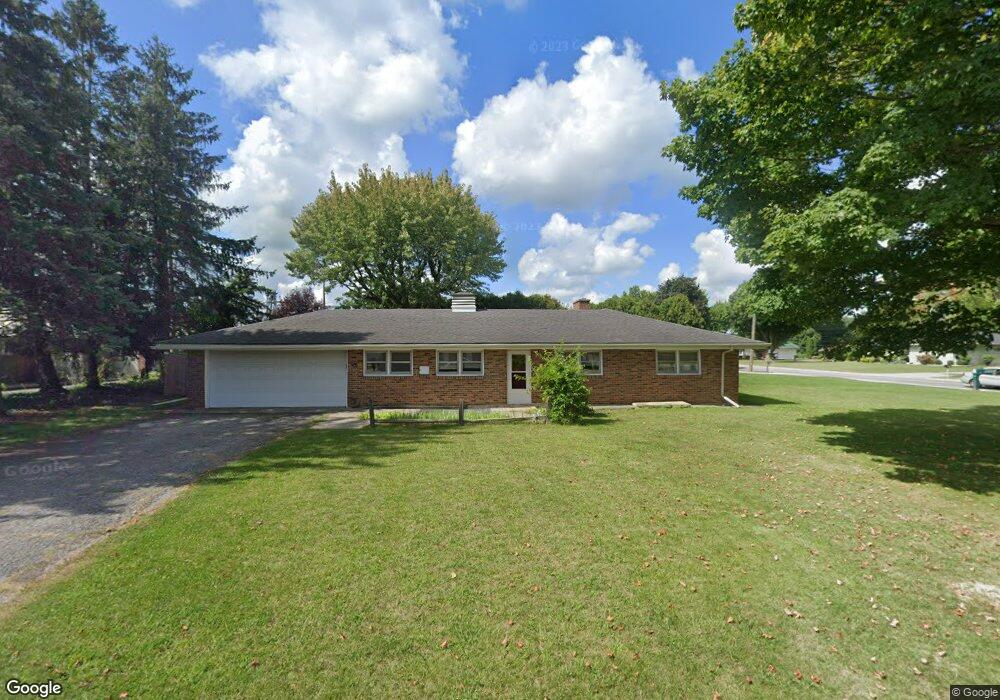
501 W Church St Upper Sandusky, OH 43351
Estimated Value: $239,449 - $303,000
3
Beds
2
Baths
1,900
Sq Ft
$137/Sq Ft
Est. Value
About This Home
This home is located at 501 W Church St, Upper Sandusky, OH 43351 and is currently estimated at $261,112, approximately $137 per square foot. 501 W Church St is a home located in Wyandot County with nearby schools including Upper Sandusky High School and St. Peter Elementary School.
Ownership History
Date
Name
Owned For
Owner Type
Purchase Details
Closed on
Nov 2, 2020
Sold by
Gottfried Lynne A and Mcguire Charlene L
Bought by
Zhao Linda and Ren Yi Biao
Current Estimated Value
Purchase Details
Closed on
Nov 14, 2018
Sold by
Gottfried Dorothy C
Bought by
Mcgurie Charlene L and Gottfried Lynn A
Create a Home Valuation Report for This Property
The Home Valuation Report is an in-depth analysis detailing your home's value as well as a comparison with similar homes in the area
Home Values in the Area
Average Home Value in this Area
Purchase History
| Date | Buyer | Sale Price | Title Company |
|---|---|---|---|
| Zhao Linda | $164,000 | None Available | |
| Mcgurie Charlene L | -- | None Available |
Source: Public Records
Tax History Compared to Growth
Tax History
| Year | Tax Paid | Tax Assessment Tax Assessment Total Assessment is a certain percentage of the fair market value that is determined by local assessors to be the total taxable value of land and additions on the property. | Land | Improvement |
|---|---|---|---|---|
| 2024 | $1,878 | $59,040 | $5,890 | $53,150 |
| 2023 | $1,878 | $59,040 | $5,890 | $53,150 |
| 2022 | $1,879 | $51,180 | $5,360 | $45,820 |
| 2021 | $1,705 | $51,180 | $5,360 | $45,820 |
| 2020 | $1,413 | $51,180 | $5,360 | $45,820 |
| 2019 | $1,411 | $51,180 | $5,360 | $45,820 |
| 2018 | $1,375 | $50,890 | $4,480 | $46,410 |
| 2017 | $1,397 | $50,890 | $4,480 | $46,410 |
| 2016 | -- | $50,890 | $4,480 | $46,410 |
| 2015 | -- | $46,400 | $4,480 | $41,920 |
| 2014 | -- | $46,400 | $4,480 | $41,920 |
| 2013 | -- | $46,400 | $4,480 | $41,920 |
Source: Public Records
Map
Nearby Homes
- 606 Polaris Dr
- 324 Keller Ct
- 453 N 7th St
- 386 W Finley St
- 620 Mission Dr
- 137 N 8th St
- 230 E Bigelow St
- 334 N 4th St
- 314 N 4th St
- 116 E Walker St
- 225 S Hazel St
- 9768 Township Road 111
- 346 W Hicks St
- 435 Front St
- 213 E Johnson St
- 326 S 8th St
- 305 S 5th St
- 430 S Sandusky Ave
- 105 River St
- 0 State Route 53 & 67 Unit 11165687
- 502 W Church St
- 505 W Church St
- 510 W Church St
- 518 W Church St
- 420 W Church St
- 527 W Church St
- 414 W Church St
- 429 W Church St
- 533 W Church St
- 503 Greenview St
- 511 Greenview St
- 421 Greenview St
- 408 W Church St
- 535 N Hazel St
- 537 W Church St
- 519 Greenview St
- 415 Greenview St
- 500 Dolly Ave
- 409 Greenview St
- 402 W Church St