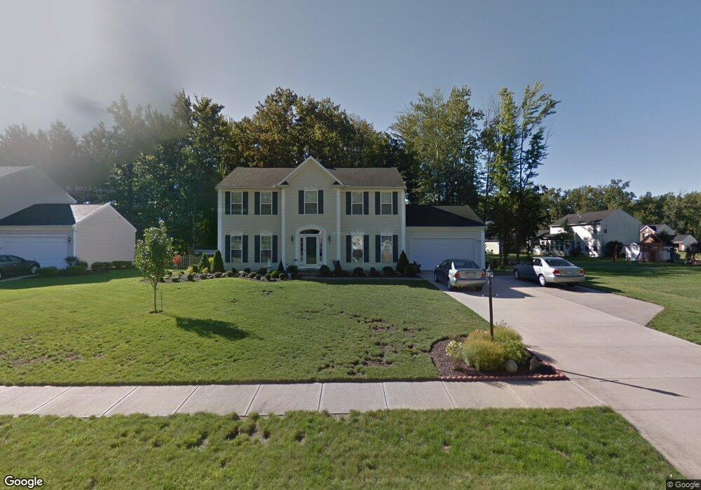
5010 Burrell Dr Sheffield Village, OH 44054
Estimated Value: $438,000 - $512,000
4
Beds
3
Baths
2,832
Sq Ft
$166/Sq Ft
Est. Value
About This Home
This home is located at 5010 Burrell Dr, Sheffield Village, OH 44054 and is currently estimated at $470,710, approximately $166 per square foot. 5010 Burrell Dr is a home located in Lorain County with nearby schools including Knollwood Elementary School, Brookside Intermediate School, and Brookside Middle School.
Ownership History
Date
Name
Owned For
Owner Type
Purchase Details
Closed on
Feb 19, 2018
Sold by
Boldgett Robert W and Boldgett Linda J
Bought by
Boldgett Linda J and Blodgett Trust
Current Estimated Value
Purchase Details
Closed on
Feb 24, 2003
Sold by
Nvr Inc
Bought by
Blodgett Robert and Blodgett Linda J
Home Financials for this Owner
Home Financials are based on the most recent Mortgage that was taken out on this home.
Original Mortgage
$93,000
Interest Rate
5.95%
Purchase Details
Closed on
Dec 12, 2002
Sold by
Abbe Industrial Park Ltd
Bought by
Nvr Inc and Ryan Homes
Create a Home Valuation Report for This Property
The Home Valuation Report is an in-depth analysis detailing your home's value as well as a comparison with similar homes in the area
Home Values in the Area
Average Home Value in this Area
Purchase History
| Date | Buyer | Sale Price | Title Company |
|---|---|---|---|
| Boldgett Linda J | -- | -- | |
| Blodgett Robert | $234,400 | Nvr Title Agency Llc | |
| Nvr Inc | $43,600 | Lorain County Title Co Inc |
Source: Public Records
Mortgage History
| Date | Status | Borrower | Loan Amount |
|---|---|---|---|
| Previous Owner | Blodgett Robert | $93,000 |
Source: Public Records
Tax History Compared to Growth
Tax History
| Year | Tax Paid | Tax Assessment Tax Assessment Total Assessment is a certain percentage of the fair market value that is determined by local assessors to be the total taxable value of land and additions on the property. | Land | Improvement |
|---|---|---|---|---|
| 2024 | $6,523 | $134,099 | $22,295 | $111,804 |
| 2023 | $5,097 | $93,450 | $19,789 | $73,661 |
| 2022 | $5,043 | $93,450 | $19,789 | $73,661 |
| 2021 | $5,076 | $93,450 | $19,790 | $73,660 |
| 2020 | $5,118 | $86,770 | $18,380 | $68,390 |
| 2019 | $5,087 | $86,770 | $18,380 | $68,390 |
| 2018 | $4,920 | $86,770 | $18,380 | $68,390 |
| 2017 | $4,730 | $73,270 | $14,700 | $58,570 |
| 2016 | $4,779 | $73,270 | $14,700 | $58,570 |
| 2015 | $4,766 | $73,270 | $14,700 | $58,570 |
| 2014 | $4,288 | $73,270 | $14,700 | $58,570 |
| 2013 | $4,267 | $73,270 | $14,700 | $58,570 |
Source: Public Records
Map
Nearby Homes
- 3006 Abbe Rd N
- 4757 Colorado Ave
- 5401 Hawks Nest Cir
- 39356 Lorreto Ct
- 0 Springfield Dr
- 38777 Country Club Dr
- 38756 Renwood Ave
- 39247 Hawthorne Dr
- 3019 Clearbrook Dr
- 4213 Berkeley Dr
- 5178 Berkeley Dr
- VL Maplewood Ave
- 39111 Princeton Cir
- 4286 Holl Ave
- 4283 Holl Ave
- 3473 Moon Rd
- 2409 Quail Hollow
- 4272 Brockley Ave
- 4260 Brockley Ave
- 699 Irving Park Blvd