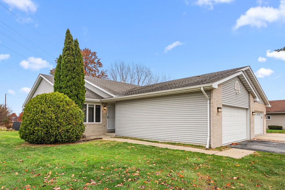
5012 W 92nd Ave Crown Point, IN 46307
Estimated payment $1,753/month
Highlights
- Vaulted Ceiling
- No HOA
- Covered Patio or Porch
- Hal E Clark Middle School Rated A-
- Neighborhood Views
- Country Kitchen
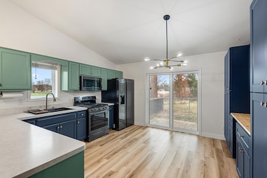
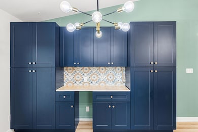
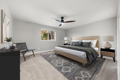
About This Home
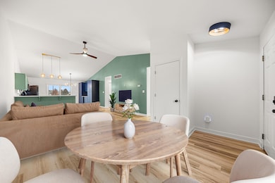
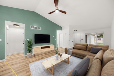
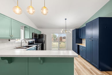
Better than new, this beautifully refreshed ranch half-duplex on a full unfinished basement features a terrific split floor plan designed to suit a wide range of lifestyles. The open layout boasts vaulted ceilings, abundant natural light, and spacious living areas enhanced by fresh paint, updated vinyl flooring, beautiful tile accents in the kitchen, a stylish farmer sink, and more. The primary suite includes a generously sized bedroom, an oversized bath, and a large walk-in closet (with a custom closet organizer), while the second bedroom is bright, spacious, and inviting. An oversized main-floor laundry room adds convenience and extra storage. Additional highlights include a 2.5-car attached garage, a private patio off the kitchen, and a basement already roughed in for a bathroom. Located right next to a new park and close to everything in an established neighborhood, this home is ready for you to make it your own!
Open House Schedule
-
Sunday, November 23, 20252:00 to 4:00 pm11/23/2025 2:00:00 PM +00:0011/23/2025 4:00:00 PM +00:00Add to Calendar
Townhouse Details
Home Type
- Townhome
Est. Annual Taxes
- $2,062
Year Built
- Built in 2000
Lot Details
- Back Yard Fenced
- Landscaped
Parking
- 2.5 Car Attached Garage
- Garage Door Opener
- Off-Street Parking
Home Design
- Half Duplex
Interior Spaces
- 1,370 Sq Ft Home
- 1-Story Property
- Vaulted Ceiling
- Living Room
- Neighborhood Views
- Basement
Kitchen
- Country Kitchen
- Gas Range
- Range Hood
- Microwave
- Dishwasher
Flooring
- Carpet
- Vinyl
Bedrooms and Bathrooms
- 2 Bedrooms
Laundry
- Laundry Room
- Laundry on main level
- Dryer
- Washer
Outdoor Features
- Covered Patio or Porch
Utilities
- Forced Air Heating and Cooling System
- Heating System Uses Natural Gas
Community Details
- No Home Owners Association
- Schererville Trace Subdivision
Listing and Financial Details
- Assessor Parcel Number 451125477003000036
- Seller Considering Concessions
Map
Home Values in the Area
Average Home Value in this Area
Tax History
| Year | Tax Paid | Tax Assessment Tax Assessment Total Assessment is a certain percentage of the fair market value that is determined by local assessors to be the total taxable value of land and additions on the property. | Land | Improvement |
|---|---|---|---|---|
| 2024 | $4,928 | $244,300 | $39,400 | $204,900 |
| 2023 | $4,109 | $242,000 | $39,400 | $202,600 |
| 2022 | $4,109 | $222,800 | $36,600 | $186,200 |
| 2020 | $3,670 | $192,900 | $36,600 | $156,300 |
| 2019 | -- | $179,500 | $32,400 | $147,100 |
| 2018 | -- | $179,900 | $32,400 | $147,500 |
| 2017 | -- | $184,900 | $32,400 | $152,500 |
| 2016 | -- | $165,400 | $32,400 | $133,000 |
| 2014 | -- | $159,100 | $32,400 | $126,700 |
| 2013 | -- | $157,000 | $32,400 | $124,600 |
Property History
| Date | Event | Price | List to Sale | Price per Sq Ft |
|---|---|---|---|---|
| 11/20/2025 11/20/25 | For Sale | $299,900 | -- | $219 / Sq Ft |
Purchase History
| Date | Type | Sale Price | Title Company |
|---|---|---|---|
| Warranty Deed | $253,000 | Community Title Company | |
| Warranty Deed | -- | Community Title Company |
Mortgage History
| Date | Status | Loan Amount | Loan Type |
|---|---|---|---|
| Open | $216,727 | FHA | |
| Previous Owner | $159,000 | Unknown |
Source: Northwest Indiana Association of REALTORS®
MLS Number: 831051
APN: 45-11-25-477-003.000-036
Disclaimer: Certain information contained herein is derived from information provided by parties other than Homes.com. All information provided is deemed reliable, but is not guaranteed to be accurate and should be independently verified.
![]() Copyright 2025 MuItiple Listing Service of the Northwest Indiana Realtors Association Multiple Listing Service (NIRA MLS). All rights reserved. IDX information is provided exclusively for personal, non-commercial use, and may not be used for any purpose other than to identify prospective properties consumers may be interested in purchasing. Information is deemed reliable but not guaranteed.
Copyright 2025 MuItiple Listing Service of the Northwest Indiana Realtors Association Multiple Listing Service (NIRA MLS). All rights reserved. IDX information is provided exclusively for personal, non-commercial use, and may not be used for any purpose other than to identify prospective properties consumers may be interested in purchasing. Information is deemed reliable but not guaranteed.
- 4862 W 92nd Ave
- 9195 Williams St
- 4944 W 89th Terrace
- 9017 Mathews St
- 5063 W 89th Ct
- 4229 W 92nd Place
- 9204 Wright St
- 8748 Durbin Ln
- 4974 W 87th Place
- 8849 Calhoun Place
- 1010 Freedom Cir N
- 1667 Chalone Ct
- 6308 W 91st Ave
- 4930 W 84th Terrace
- 6501 W 89th Ave
- 6076 Wexford Way
- 841 Veterans Ln
- 6440 W 89th Ave
- 6915 W 93rd Ave
- 5547 Maggie Mae Ct
- 801 Veterans Ln
- 8413 Jennings Place
- 8162 Westwood Ct
- 8118 International Dr
- 3119 W 82nd Place Unit 53b
- 3117 W 82nd Place Unit 53a
- 3103 W 82nd Place Unit 52b
- 6939 W 85th Ave
- 7989 Morton St
- 2100 N Main St
- 2701 Morningside Dr Unit 1
- 351 Maple St
- 3944 W 77th Place
- 9123 Cleveland St
- 1445 Grandview Ct
- 7654 Whitcomb St Unit D
- 3755 W 75th Ct Unit ID1285097P
- 9614 Dona Ct
- 8201 Polo Club Dr
- 8400 Grant Cir
