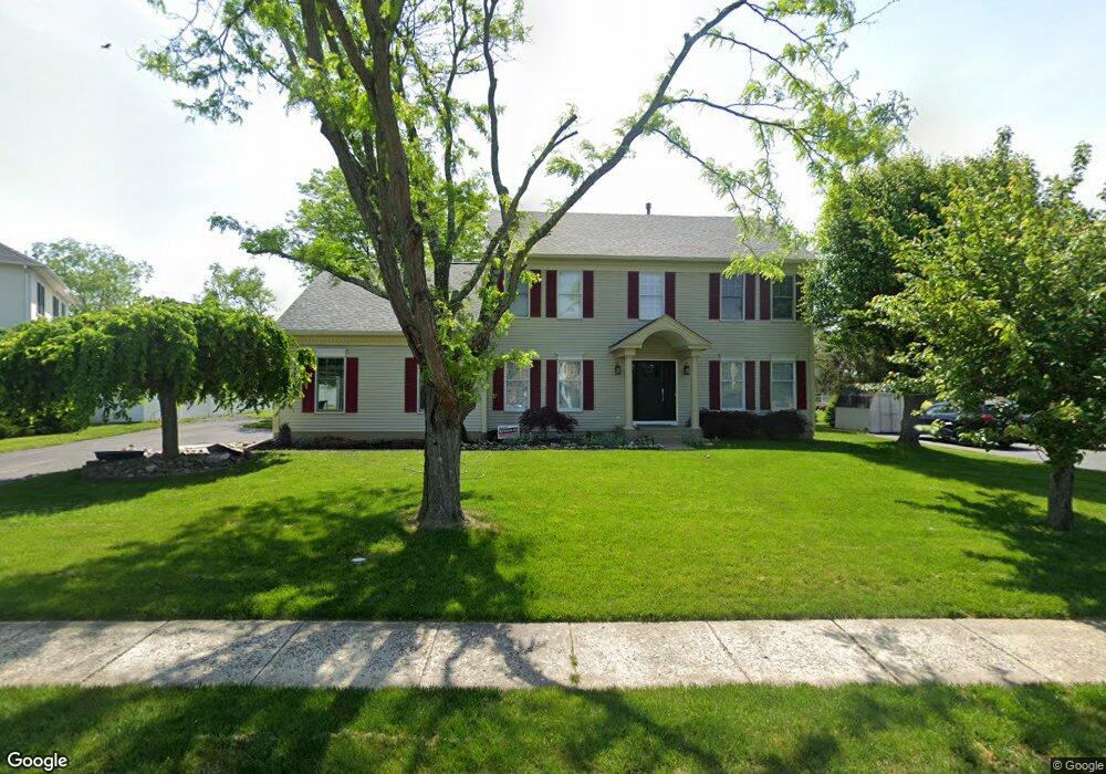
5015 Cookes Ln Doylestown, PA 18902
Estimated Value: $810,849 - $854,000
4
Beds
3
Baths
2,704
Sq Ft
$310/Sq Ft
Est. Value
About This Home
This home is located at 5015 Cookes Ln, Doylestown, PA 18902 and is currently estimated at $839,462, approximately $310 per square foot. 5015 Cookes Ln is a home located in Bucks County with nearby schools including Cold Spring Elementary School, Holicong Middle School, and Central Bucks High School - East.
Ownership History
Date
Name
Owned For
Owner Type
Purchase Details
Closed on
Aug 7, 1996
Sold by
Howe Timothy V and Howe Patricia R
Bought by
Milici Kevin T and Milici Helen D
Current Estimated Value
Home Financials for this Owner
Home Financials are based on the most recent Mortgage that was taken out on this home.
Original Mortgage
$197,500
Interest Rate
7.82%
Purchase Details
Closed on
Jun 29, 1995
Sold by
Cold Spring Hunt Lp
Bought by
Howe Timothy and Howe Patricia R
Home Financials for this Owner
Home Financials are based on the most recent Mortgage that was taken out on this home.
Original Mortgage
$211,000
Interest Rate
6.87%
Create a Home Valuation Report for This Property
The Home Valuation Report is an in-depth analysis detailing your home's value as well as a comparison with similar homes in the area
Home Values in the Area
Average Home Value in this Area
Purchase History
| Date | Buyer | Sale Price | Title Company |
|---|---|---|---|
| Milici Kevin T | $246,900 | -- | |
| Howe Timothy | $263,787 | -- |
Source: Public Records
Mortgage History
| Date | Status | Borrower | Loan Amount |
|---|---|---|---|
| Previous Owner | Milici Kevin T | $197,500 | |
| Previous Owner | Howe Timothy | $211,000 |
Source: Public Records
Tax History
| Year | Tax Paid | Tax Assessment Tax Assessment Total Assessment is a certain percentage of the fair market value that is determined by local assessors to be the total taxable value of land and additions on the property. | Land | Improvement |
|---|---|---|---|---|
| 2025 | $8,642 | $53,080 | $10,360 | $42,720 |
| 2024 | $8,642 | $53,080 | $10,360 | $42,720 |
| 2023 | $8,349 | $53,080 | $10,360 | $42,720 |
| 2022 | $8,249 | $53,080 | $10,360 | $42,720 |
| 2021 | $8,150 | $53,080 | $10,360 | $42,720 |
| 2020 | $8,150 | $53,080 | $10,360 | $42,720 |
| 2019 | $8,097 | $53,080 | $10,360 | $42,720 |
| 2018 | $8,097 | $53,080 | $10,360 | $42,720 |
| 2017 | $8,031 | $53,080 | $10,360 | $42,720 |
| 2016 | $8,111 | $53,080 | $10,360 | $42,720 |
| 2015 | -- | $53,080 | $10,360 | $42,720 |
| 2014 | -- | $53,080 | $10,360 | $42,720 |
Source: Public Records
Map
Nearby Homes
- 5087 Raintree Ct
- 3960 S Mallard Ln
- 4783 Landisville Rd
- 4533 Deep Creek Way
- 4179 Miladies Ln
- 3689 Hancock Ln
- 5491 Long Ln
- 3468 Holicong Rd
- 4745 Nottingham Way
- 4990 Point Pleasant Pike
- 5182 Point Pleasant Pike
- 6680 Point Pleasant Pike
- 5380 Point Pleasant Pike
- 5829 Ridgeview Dr
- 5805 Ridgeview Dr
- 6185 Mechanicsville Rd
- 3039 Durham Rd
- 30 John Dyer Way
- 4215 Ferguson Dr
- 2916 White Tail Ct
Your Personal Tour Guide
Ask me questions while you tour the home.