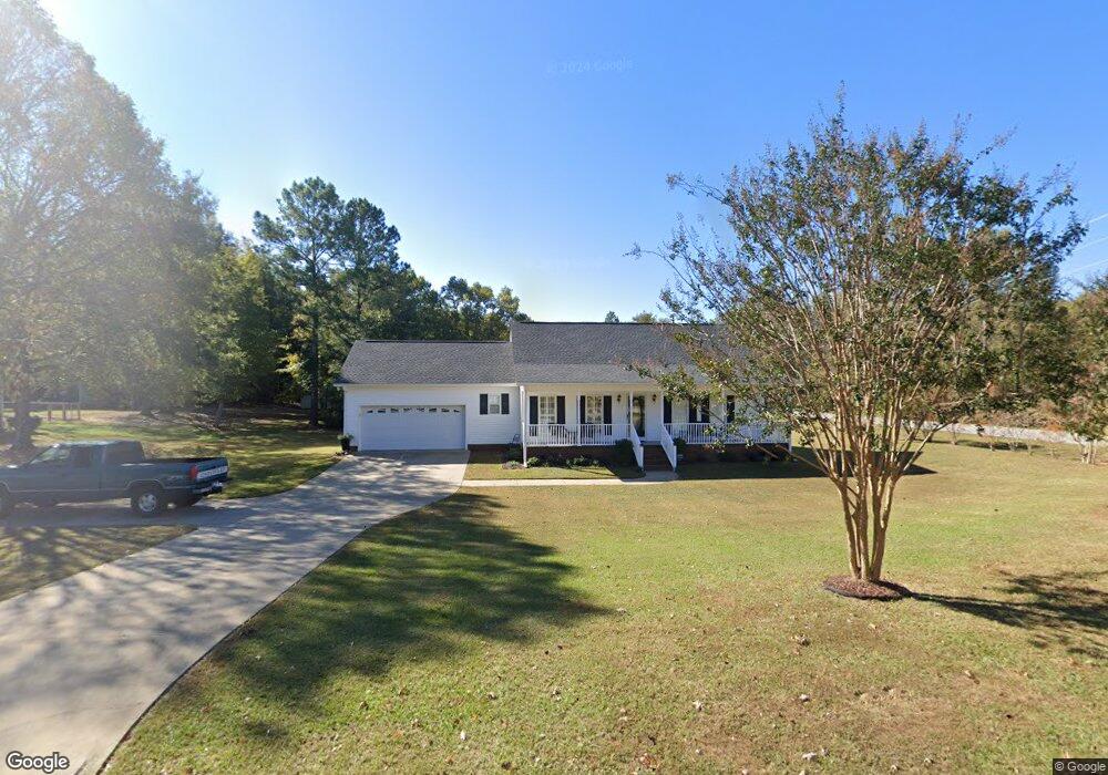
502 Station East Ln Roebuck, SC 29376
Estimated Value: $247,254 - $269,000
3
Beds
2
Baths
1,370
Sq Ft
$187/Sq Ft
Est. Value
About This Home
This home is located at 502 Station East Ln, Roebuck, SC 29376 and is currently estimated at $256,064, approximately $186 per square foot. 502 Station East Ln is a home located in Spartanburg County with nearby schools including Dorman High School Freshman Campus and Dorman High School.
Ownership History
Date
Name
Owned For
Owner Type
Purchase Details
Closed on
Jul 29, 2019
Sold by
Thomas Dorothy K
Bought by
Craddock Otho Jimmy and Weise Deborah Adell
Current Estimated Value
Home Financials for this Owner
Home Financials are based on the most recent Mortgage that was taken out on this home.
Original Mortgage
$141,750
Outstanding Balance
$123,955
Interest Rate
3.73%
Mortgage Type
New Conventional
Estimated Equity
$132,109
Purchase Details
Closed on
Oct 14, 2003
Sold by
Terry Judy G
Bought by
Thomas Dorothy K
Purchase Details
Closed on
Feb 28, 2003
Sold by
Greene George W
Bought by
Terry Judy G
Purchase Details
Closed on
Aug 21, 2002
Sold by
Smith & Lowe Development Inc
Bought by
Greene George W
Create a Home Valuation Report for This Property
The Home Valuation Report is an in-depth analysis detailing your home's value as well as a comparison with similar homes in the area
Home Values in the Area
Average Home Value in this Area
Purchase History
| Date | Buyer | Sale Price | Title Company |
|---|---|---|---|
| Craddock Otho Jimmy | $157,500 | None Available | |
| Thomas Dorothy K | $130,000 | -- | |
| Terry Judy G | $124,500 | -- | |
| Greene George W | $12,500 | -- |
Source: Public Records
Mortgage History
| Date | Status | Borrower | Loan Amount |
|---|---|---|---|
| Open | Craddock Otho Jimmy | $141,750 | |
| Closed | Craddock Otho Jimmy | $141,750 |
Source: Public Records
Tax History Compared to Growth
Tax History
| Year | Tax Paid | Tax Assessment Tax Assessment Total Assessment is a certain percentage of the fair market value that is determined by local assessors to be the total taxable value of land and additions on the property. | Land | Improvement |
|---|---|---|---|---|
| 2025 | $976 | $7,245 | $781 | $6,464 |
| 2024 | $976 | $7,245 | $781 | $6,464 |
| 2023 | $976 | $7,245 | $781 | $6,464 |
| 2022 | $832 | $6,300 | $800 | $5,500 |
| 2021 | $822 | $6,300 | $800 | $5,500 |
| 2020 | $1,146 | $6,300 | $800 | $5,500 |
| 2019 | $727 | $5,994 | $691 | $5,303 |
| 2018 | $729 | $5,994 | $691 | $5,303 |
| 2017 | $589 | $5,212 | $720 | $4,492 |
| 2016 | $602 | $5,212 | $720 | $4,492 |
| 2015 | $592 | $5,212 | $720 | $4,492 |
| 2014 | $571 | $5,212 | $720 | $4,492 |
Source: Public Records
Map
Nearby Homes
- 95 State Road S-42-9964
- 95 Stone Station Farm
- 310 Templeton Dr
- 0 Stone Station Rd
- Harrison Rd
- 340 Harrison Rd
- 315 Sabrewood Ln
- 1523 Old Canaan Rd
- 379 Lawtonwood Ln
- 120 State Road S-42-9962
- 0 Cavalier Conection Dr Unit 298383
- 660 Hunters Rd
- 0 Freedom Trail
- 409 Balfour Rd
- 100 Caroline Dr
- 1350 Old Canaan Rd
- 0 Independence Ct
- 161 Caroline Dr
- 365 Guernsey Ln
- 228 Muirfield Dr
- 508 Station East Ln
- 508 Station Ln E
- 285 Walnut Grove Rd
- 503 Station East Ln
- 503 Station Ln E
- 605 Station West Ln
- 514 Station East Ln
- 295 Walnut Grove Rd
- 606 Station West Ln
- 509 Station East Ln
- 255 Walnut Grove Rd
- 254 Walnut Grove Rd
- 319 Walnut Grove Rd
- 520 Station East Ln
- 521 Station East Ln
- 611 Station West Ln
- 612 Station West Ln
- 515 Station East Ln
- 617 Station West Ln
- 618 Station West Ln