


5025 Highway 72 Killen, AL 35645
Estimated Value: $70,095 - $325,000
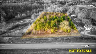
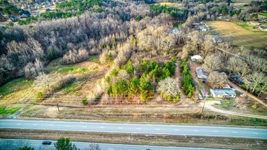
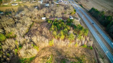
2.49
Acres
$79,337
Price per Acre
108,464
Sq Ft Lot
Highlights
- No HOA
- Brooks Elementary School Rated A-
- Rectangular Lot
About This Lot
As of January 2022A chance to develop an income producing property, begin your commercial endeavor, or build a home for yourself! This 2.49 acre property features 259 feet of road frontage on Highway 72 in Killen just one mile east of Brooks High School.
Last Agent to Sell the Property
CODY MCCOY
ag Real Estate License #113260 Listed on: 12/22/2021
Property Details
Property Type
- Land
Est. Annual Taxes
- $160
Lot Details
- 2.49 Acre Lot
- Lot Dimensions are 259x420
- Property fronts a highway
- Property fronts an easement
- Rectangular Lot
- Level Lot
Schools
- City/County Elementary And Middle School
- City/County High School
Community Details
- No Home Owners Association
- Killen Community
- Killen Subdivision
Listing and Financial Details
- Assessor Parcel Number 17-05-21-0-000-046.000
Ownership History
Date
Name
Owned For
Owner Type
Purchase Details
Closed on
Jan 24, 2025
Sold by
H B Holdings Llc
Bought by
Perkins Cristopher L
Current Estimated Value
Purchase Details
Closed on
Sep 17, 2024
Sold by
Ames David
Bought by
H B Holdings Llc
Purchase Details
Closed on
Apr 18, 2016
Sold by
Kelley Carnell
Bought by
Kelley Eric A and Kelley Alan Keith
Similar Properties in Killen, AL
Create a Home Valuation Report for This Property
The Home Valuation Report is an in-depth analysis detailing your home's value as well as a comparison with similar homes in the area
Home Values in the Area
Average Home Value in this Area
Purchase History
| Date | Buyer | Sale Price | Title Company |
|---|---|---|---|
| Perkins Cristopher L | $55,000 | Attorney Only | |
| H B Holdings Llc | $70,000 | Attorney Only | |
| Kelley Eric A | $21,200 | -- |
Source: Public Records
Mortgage History
| Date | Status | Borrower | Loan Amount |
|---|---|---|---|
| Previous Owner | Spalding Michael | $19,125 |
Source: Public Records
Property History
| Date | Event | Price | Change | Sq Ft Price |
|---|---|---|---|---|
| 01/13/2022 01/13/22 | Sold | $65,000 | 0.0% | -- |
| 01/02/2022 01/02/22 | Pending | -- | -- | -- |
| 12/22/2021 12/22/21 | For Sale | $65,000 | -- | -- |
Source: Strategic MLS Alliance (Cullman / Shoals Area)
Tax History Compared to Growth
Tax History
| Year | Tax Paid | Tax Assessment Tax Assessment Total Assessment is a certain percentage of the fair market value that is determined by local assessors to be the total taxable value of land and additions on the property. | Land | Improvement |
|---|---|---|---|---|
| 2024 | $272 | $7,760 | $7,760 | $0 |
| 2023 | $272 | $7,120 | $7,120 | $0 |
| 2022 | $199 | $5,680 | $0 | $0 |
| 2021 | $174 | $4,960 | $0 | $0 |
| 2020 | $160 | $4,580 | $0 | $0 |
| 2019 | $160 | $4,580 | $0 | $0 |
| 2018 | $163 | $4,660 | $0 | $0 |
| 2017 | $148 | $4,240 | $0 | $0 |
| 2016 | $148 | $4,240 | $0 | $0 |
| 2015 | $148 | $4,240 | $0 | $0 |
| 2014 | $144 | $4,120 | $0 | $0 |
Source: Public Records
Agents Affiliated with this Home
-
Seller's Agent in 2022
CODY MCCOY
ag Real Estate
(256) 710-8021
52 Total Sales
-
Debbie Elmore
D
Buyer's Agent in 2022
Debbie Elmore
RE Max Legacy
(256) 434-7510
10 Total Sales
Map
Source: Strategic MLS Alliance (Cullman / Shoals Area)
MLS Number: 502847
APN: 17-05-21-0-000-046.000
Disclaimer: Certain information contained herein is derived from information provided by parties other than Homes.com. All information provided is deemed reliable, but is not guaranteed to be accurate and should be independently verified.
![]() IDX information is provided exclusively for personal, non-commercial use, and may not be used for any purpose other than to identify prospective properties consumers may be interested in purchasing. Information is deemed reliable but not guaranteed.
IDX information is provided exclusively for personal, non-commercial use, and may not be used for any purpose other than to identify prospective properties consumers may be interested in purchasing. Information is deemed reliable but not guaranteed.
Nearby Homes
- 833 J C Mauldin Hwy
- 0 Simpson St
- 222 Bridge Rd
- 00 County Road 25
- 0 Cooper Rd Unit 522317
- 741 Preakness Dr
- 0 Cooper Rd Unit 521948
- 0 Stone Run Unit RTC2812075
- 0 Stone Run Unit 521702
- Lot 2 Cox Rd
- 107 Wallace Cir
- 233 Chasebrook Dr
- 617 Alabama St
- 000 Alabama St
- 0 County Road 465
- 951 Turtle Cove
- 330 Oak St
- 0 Heron CV Rd Unit 521608
- 538 Heron Cove Rd
- 000 County Road 71
- 3015 Highway 72
- 0.69 Acres Highway 72
- 5025 Highway 72
- 8780 Highway 72
- 000 Highway 72
- 331 Highway 72
- 102 McPeters Dr
- 106 McPeters Dr
- .40 Tract 2 McPeters Dr
- 2400 Highway 72
- 125 Mc Peters Dr
- 00 Mc Peters Dr
- .40 Tract 1 McPeters Dr
- 2411 Highway 72
- 211 Shoreline Dr
- 905 Joan Ln
- 215 Shoreline Dr
- 201 Shoreline Dr
- 2560 U S 72
- 185 Shoreline Dr