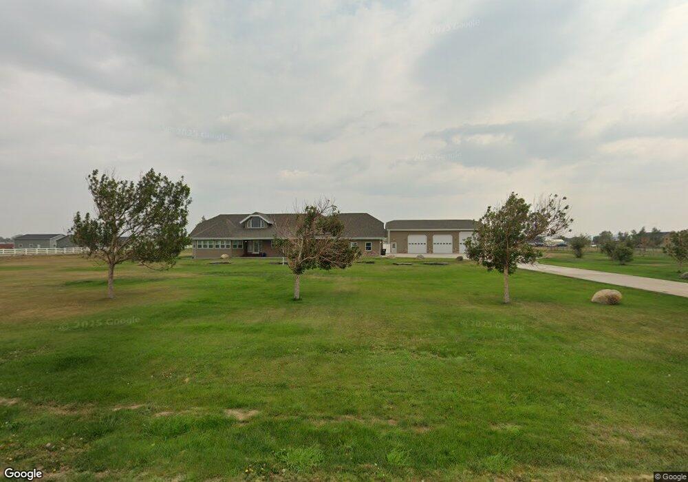
5030 Maribrooke Rd Shepherd, MT 59079
Estimated Value: $673,000 - $809,199
3
Beds
3
Baths
3,091
Sq Ft
$235/Sq Ft
Est. Value
About This Home
This home is located at 5030 Maribrooke Rd, Shepherd, MT 59079 and is currently estimated at $727,066, approximately $235 per square foot. 5030 Maribrooke Rd is a home located in Yellowstone County with nearby schools including Shepherd Elementary School, Shepherd Middle School, and Shepherd High School.
Ownership History
Date
Name
Owned For
Owner Type
Purchase Details
Closed on
Sep 22, 2024
Sold by
Fick Richard Edward
Bought by
Stark Kymmberly S
Current Estimated Value
Home Financials for this Owner
Home Financials are based on the most recent Mortgage that was taken out on this home.
Original Mortgage
$450,000
Outstanding Balance
$439,797
Interest Rate
2.5%
Mortgage Type
New Conventional
Estimated Equity
$287,269
Purchase Details
Closed on
Aug 29, 2019
Sold by
Walborn J Barbara Est
Bought by
Nickel Dennis D
Purchase Details
Closed on
Mar 23, 2016
Sold by
Nickel Dennis D
Bought by
Walborn Barbara J
Home Financials for this Owner
Home Financials are based on the most recent Mortgage that was taken out on this home.
Interest Rate
3.73%
Purchase Details
Closed on
Oct 24, 2013
Sold by
Norriss W Michael and Norriss Sheryl L
Bought by
Walborn Barbara J and Nickel Dennis D
Home Financials for this Owner
Home Financials are based on the most recent Mortgage that was taken out on this home.
Original Mortgage
$380,000
Interest Rate
4.46%
Mortgage Type
New Conventional
Purchase Details
Closed on
Aug 13, 2008
Sold by
Rost Homes Inc
Bought by
Norriss W Michael W and Norriss Sheryl L
Purchase Details
Closed on
Nov 30, 2005
Sold by
Norriss W Michael
Bought by
Norriss W Michael and Norriss Sheryl L
Home Financials for this Owner
Home Financials are based on the most recent Mortgage that was taken out on this home.
Original Mortgage
$344,000
Interest Rate
5.97%
Mortgage Type
New Conventional
Purchase Details
Closed on
Nov 21, 2005
Sold by
Norriss W Michael
Bought by
Norriss Sheryl L
Home Financials for this Owner
Home Financials are based on the most recent Mortgage that was taken out on this home.
Original Mortgage
$344,000
Interest Rate
5.97%
Mortgage Type
New Conventional
Purchase Details
Closed on
Nov 9, 2005
Sold by
Norriss Sheryl L
Bought by
Norriss W Michael and Norriss Sheryl L
Home Financials for this Owner
Home Financials are based on the most recent Mortgage that was taken out on this home.
Original Mortgage
$344,000
Interest Rate
5.97%
Mortgage Type
New Conventional
Purchase Details
Closed on
Nov 8, 2005
Sold by
Norriss Sheryl L
Bought by
Norriss W Michael
Home Financials for this Owner
Home Financials are based on the most recent Mortgage that was taken out on this home.
Original Mortgage
$344,000
Interest Rate
5.97%
Mortgage Type
New Conventional
Create a Home Valuation Report for This Property
The Home Valuation Report is an in-depth analysis detailing your home's value as well as a comparison with similar homes in the area
Home Values in the Area
Average Home Value in this Area
Purchase History
| Date | Buyer | Sale Price | Title Company |
|---|---|---|---|
| Stark Kymmberly S | -- | None Listed On Document | |
| Nickel Dennis D | $450,000,000 | -- | |
| Walborn Barbara J | -- | -- | |
| Walborn Barbara J | -- | Chicago Title | |
| Norriss W Michael W | -- | None Available | |
| Norriss W Michael | -- | First Montana Title | |
| Norriss Sheryl L | -- | None Available | |
| Norriss W Michael | -- | None Available | |
| Norriss W Michael | -- | None Available |
Source: Public Records
Mortgage History
| Date | Status | Borrower | Loan Amount |
|---|---|---|---|
| Open | Stark Kymmberly S | $450,000 | |
| Previous Owner | Walborn Barbara J | -- | |
| Previous Owner | Walborn Barbara J | $380,000 | |
| Previous Owner | Norriss W Michael | $344,000 |
Source: Public Records
Tax History Compared to Growth
Tax History
| Year | Tax Paid | Tax Assessment Tax Assessment Total Assessment is a certain percentage of the fair market value that is determined by local assessors to be the total taxable value of land and additions on the property. | Land | Improvement |
|---|---|---|---|---|
| 2025 | $6,221 | $741,600 | $107,129 | $634,471 |
| 2024 | $6,221 | $720,100 | $79,817 | $640,283 |
| 2023 | $6,328 | $720,100 | $79,817 | $640,283 |
| 2022 | $5,366 | $570,700 | $0 | $0 |
| 2021 | $5,640 | $570,700 | $0 | $0 |
| 2020 | $5,460 | $532,700 | $0 | $0 |
| 2019 | $4,535 | $532,700 | $0 | $0 |
| 2018 | $4,620 | $511,000 | $0 | $0 |
| 2017 | $4,091 | $511,000 | $0 | $0 |
| 2016 | $4,068 | $481,900 | $0 | $0 |
| 2015 | $4,039 | $520,900 | $0 | $0 |
| 2014 | $3,599 | $228,271 | $0 | $0 |
Source: Public Records
Map
Nearby Homes
- 4935 Lewies Way
- 4820 Maribrooke Rd
- 7133 Mustang Rd
- 5358 Yeoman Rd
- 6447 US Highway 312
- 7306 Kendra Lynn Dr
- L5B4 Trumbo Cir
- 5840,5850,5904 Lunder Ln
- L3B4 Trumbo Cir
- 6634 Killdeer Ln
- L4B4 Trumbo Cir
- L11B3 High Noon Dr
- L13B2 High Noon Dr
- L12B3 Molly Dr
- L2B4 True Grit St
- 5510 Powmer Rd
- L1B4 True Grit St
- L13B3 Molly Dr
- L11B2 Rio Lobo Cir
- L12B2 High Noon Dr
- 0 John Hogan Trail
- 5010 John Hogan Trail
- 4925 John Hogan Trail
- 5035 Maribrooke Rd
- 5005 John Hogan Trail
- 4915 John Hogan Trail
- 5025 Lewies Way
- 5015 Maribrooke Rd
- 0 Lewies Way
- 5015 John Hogan Trail
- 4910 Maribrooke Rd
- 5125 Lewies Way
- 4945 Maribrooke Rd
- 5010 Lewies Way
- 4820 John Hogan Trail
- 5055 Lewies Way
- 6727 Hofferber Rd
- 4815 John Hogan Trail
- 5030 Lewies Way
- 5035 John Hogan Trail