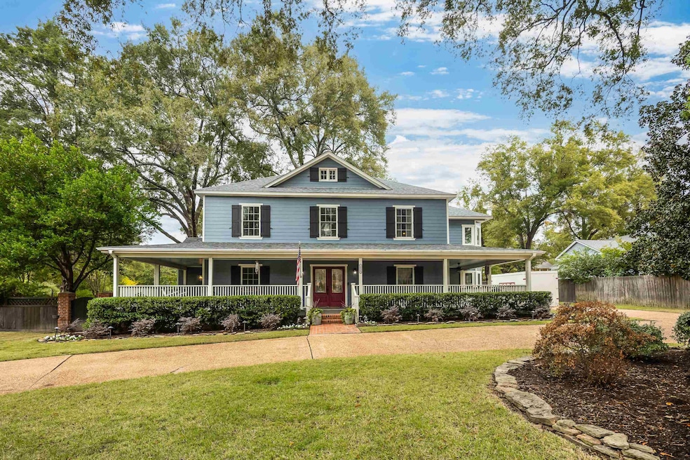
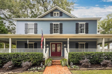
5030 Shady Grove Rd Memphis, TN 38117
Audubon Park NeighborhoodEstimated payment $3,265/month
Highlights
- Sitting Area In Primary Bedroom
- Updated Kitchen
- Deck
- White Station High Rated A
- Landscaped Professionally
- Traditional Architecture
About This Home
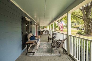
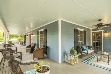
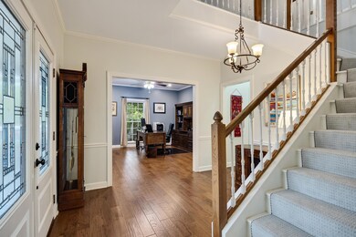
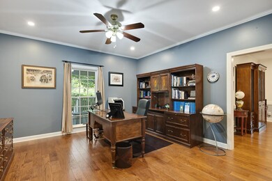
Don't miss this beautiful 4 bed, 3 bath, 3,400 sq ft home conveniently located near all that East Memphis has to offer! From the circular drive to the wrap-around porch, you'll be charmed the moment you arrive. Picture yourself cozying up by the wood-burning fireplace in the inviting den, entertaining on the gorgeous patio around the outdoor fireplace this fall, or cooking for family gatherings in the spacious kitchen during the holidays. The sellers have meticulously maintained and improved this home over the years: new mini split in the sunroom for year-round comfort, partial kitchen update two years ago (new range, dishwasher, luxury vinyl tile flooring, quartz countertops, farmhouse sink, butcher block island top), new roof 2024, Hardie plank siding, noise-reducing double-pane windows, tankless water heater 2018, AC units replaced within past 3 years, fresh exterior paint, updated flooring – the list goes on! Come see it!!
Home Details
Home Type
- Single Family
Est. Annual Taxes
- $3,475
Year Built
- Built in 1986
Lot Details
- 0.36 Acre Lot
- Lot Dimensions are 130x140
- Wood Fence
- Landscaped Professionally
- Corner Lot
- Few Trees
Home Design
- Traditional Architecture
- Slab Foundation
- Composition Shingle Roof
Interior Spaces
- 3,406 Sq Ft Home
- 2-Story Property
- Built-in Bookshelves
- Smooth Ceilings
- Ceiling Fan
- Fireplace Features Masonry
- Some Wood Windows
- Double Pane Windows
- Window Treatments
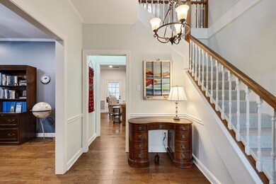
- Two Story Entrance Foyer
- Separate Formal Living Room
- Dining Room
- Den with Fireplace
- Sun or Florida Room
- Storage Room
- Pull Down Stairs to Attic
Kitchen
- Updated Kitchen
- Eat-In Kitchen
- Breakfast Bar
- Oven or Range
- Microwave
- Dishwasher
- Kitchen Island
- Farmhouse Sink
- Disposal
Flooring
- Wood
- Tile
Bedrooms and Bathrooms
- 4 Bedrooms | 1 Main Level Bedroom
- Sitting Area In Primary Bedroom
- Primary bedroom located on second floor
- En-Suite Bathroom
- Walk-In Closet
- 3 Full Bathrooms
- Dual Vanity Sinks in Primary Bathroom
- Whirlpool Bathtub
- Bathtub With Separate Shower Stall
Laundry
- Laundry Room
- Washer and Dryer Hookup
Home Security
- Monitored
- Fire and Smoke Detector
- Termite Clearance
Parking
- 2 Car Garage
- Side Facing Garage
- Circular Driveway
Outdoor Features
- Deck
- Patio
- Porch
Utilities
- Central Heating and Cooling System
- Heating System Uses Gas
- Gas Water Heater
- Cable TV Available
Community Details
- Mendenhall Grove Subdivision
Listing and Financial Details
- Assessor Parcel Number 056025 00023
Map
Home Values in the Area
Average Home Value in this Area
Tax History
| Year | Tax Paid | Tax Assessment Tax Assessment Total Assessment is a certain percentage of the fair market value that is determined by local assessors to be the total taxable value of land and additions on the property. | Land | Improvement |
|---|---|---|---|---|
| 2025 | $3,475 | $133,075 | $38,450 | $94,625 |
| 2024 | $3,475 | $102,500 | $34,425 | $68,075 |
| 2023 | $6,244 | $102,500 | $34,425 | $68,075 |
| 2022 | $6,244 | $102,500 | $34,425 | $68,075 |
| 2021 | $6,317 | $102,500 | $34,425 | $68,075 |
| 2020 | $6,415 | $88,525 | $34,425 | $54,100 |
| 2019 | $6,415 | $88,525 | $34,425 | $54,100 |
| 2018 | $6,415 | $88,525 | $34,425 | $54,100 |
| 2017 | $3,638 | $88,525 | $34,425 | $54,100 |
| 2016 | $4,276 | $97,850 | $0 | $0 |
| 2014 | $4,276 | $97,850 | $0 | $0 |
Property History
| Date | Event | Price | List to Sale | Price per Sq Ft |
|---|---|---|---|---|
| 11/10/2025 11/10/25 | Pending | -- | -- | -- |
| 10/29/2025 10/29/25 | For Sale | $565,000 | -- | $166 / Sq Ft |
Purchase History
| Date | Type | Sale Price | Title Company |
|---|---|---|---|
| Warranty Deed | $308,000 | Realty Title & Escrow Co Inc | |
| Warranty Deed | $299,000 | -- | |
| Warranty Deed | $299,000 | -- | |
| Deed | $225,000 | -- |
Mortgage History
| Date | Status | Loan Amount | Loan Type |
|---|---|---|---|
| Open | $292,600 | Purchase Money Mortgage | |
| Previous Owner | $307,970 | No Value Available |
Source: Memphis Area Association of REALTORS®
MLS Number: 10208674
APN: 05-6025-0-0023
Disclaimer: Certain information contained herein is derived from information provided by parties other than Homes.com. All information provided is deemed reliable, but is not guaranteed to be accurate and should be independently verified.
![]() Listing content and images Copyright 2025 Memphis Area Association of REALTORS®. Information provided is for the consumer’s personal, non-commercial use and may not be used for any purpose other than to identify prospective properties consumers may be interested in purchasing. Do not rely upon listing data without independently verifying it.
Listing content and images Copyright 2025 Memphis Area Association of REALTORS®. Information provided is for the consumer’s personal, non-commercial use and may not be used for any purpose other than to identify prospective properties consumers may be interested in purchasing. Do not rely upon listing data without independently verifying it.
Some or all of the listings displayed may not belong to the firm whose website is being visited.
- 267 Barry Rd
- 5094 Cole Rd
- 5055 Greenway Rd
- 264 Barry Rd
- 5157 S Angela Rd
- 344 Greenway Place
- 4915 Lake Dr
- 65 Laverne Ln
- 50 Grove Creek Place
- 5170 Meadowcrest Cir
- 5068 Walnut Grove Rd
- 254 S White Station Rd
- 5188 Gwynne Rd
- 5256 Collingwood Rd
- 4975 Brookwood Cove
- 371 Saint Nick Dr
- 4841 Fleetgrove Ave
- 5264 S Angela Rd
- 364 Clawson Cove
- 4772 Gwynne Rd
