


5031 Appalachain Dr Goodlettsville, TN 37072
Highlights
- No HOA
- Central Heating and Cooling System
- Carpet
- 2 Car Attached Garage
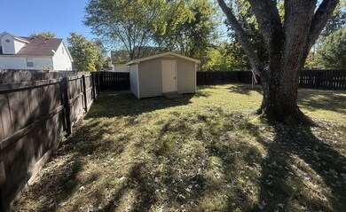
- Privacy Fence
About This Home
SAT. NOV. 22 @ 10AM
ESTATE AUCTION!
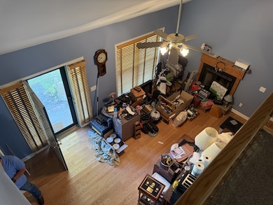
This two story house contains 1492 +/- sq. ft. consisting of 3BR, 2.5BA, LV, DR with attached 2 car garage It features a deck and fenced back yard with storage building. The main bedroom is on ground floor with two upstairs. Hardwood floors in living room/Dining Room and new carpet upstairs! Fireplace insert in LV. Corner lot and paved drive to side facing attached garage makes this place have great curb appeal. Very nicely located – this is a great place you can call home. Don’t miss it!
Listing Agent
Cope Associates Realty & Auction, LLC Brokerage Phone: 6155339234 License #321688 Listed on: 10/21/2025
Home Details
Home Type
- Single Family
Est. Annual Taxes
- $2,049
Year Built
- Built in 1998
Lot Details
- 0.26 Acre Lot
- Privacy Fence
Parking
- 2 Car Attached Garage
Home Design
- Shingle Roof
- Vinyl Siding
Interior Spaces
- 1,852 Sq Ft Home
- Property has 2 Levels
- Living Room with Fireplace
- Carpet
- Crawl Space
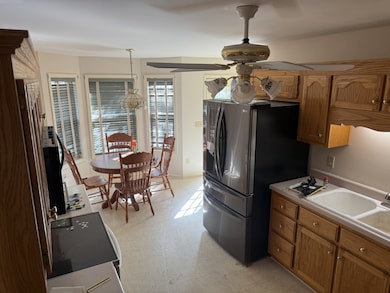
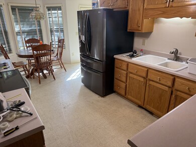
Kitchen
- Oven or Range
- Dishwasher
Bedrooms and Bathrooms
- 3 Main Level Bedrooms
- 2 Full Bathrooms
Schools
- Robert F. Woodall Elementary School
- White House Heritage Elementary Middle School
- White House Heritage High School
Utilities
- Central Heating and Cooling System
Community Details
- No Home Owners Association
- Shenandoah Sec II Replat Subdivision
Listing and Financial Details
- Assessor Parcel Number 126O A 02600 000
Map
Home Values in the Area
Average Home Value in this Area
Tax History
| Year | Tax Paid | Tax Assessment Tax Assessment Total Assessment is a certain percentage of the fair market value that is determined by local assessors to be the total taxable value of land and additions on the property. | Land | Improvement |
|---|---|---|---|---|
| 2025 | -- | $82,975 | $0 | $0 |
| 2024 | -- | $82,975 | $25,000 | $57,975 |
| 2023 | $2,199 | $82,975 | $25,000 | $57,975 |
| 2022 | $1,842 | $51,500 | $7,025 | $44,475 |
| 2021 | $1,842 | $51,500 | $7,025 | $44,475 |
| 2020 | $1,842 | $51,500 | $7,025 | $44,475 |
| 2019 | $1,842 | $51,500 | $7,025 | $44,475 |
| 2018 | $1,842 | $51,500 | $7,025 | $44,475 |
| 2017 | $1,467 | $35,900 | $5,500 | $30,400 |
| 2016 | $1,411 | $35,900 | $5,500 | $30,400 |
| 2015 | $1,366 | $35,900 | $5,500 | $30,400 |
| 2014 | $1,366 | $35,900 | $5,500 | $30,400 |
Property History
| Date | Event | Price | List to Sale | Price per Sq Ft |
|---|---|---|---|---|
| 11/22/2025 11/22/25 | Pending | -- | -- | -- |
| 10/21/2025 10/21/25 | For Sale | -- | -- | -- |
Purchase History
| Date | Type | Sale Price | Title Company |
|---|---|---|---|
| Deed | $116,900 | -- | |
| Warranty Deed | $321,000 | -- |
Mortgage History
| Date | Status | Loan Amount | Loan Type |
|---|---|---|---|
| Open | $93,500 | No Value Available |
Source: Realtracs
MLS Number: 3031722
APN: 126O-A-026.00
Disclaimer: Certain information contained herein is derived from information provided by parties other than Homes.com. All information provided is deemed reliable, but is not guaranteed to be accurate and should be independently verified.
![]() Based on information submitted to the MLS GRID. All data is obtained from various sources and may not have been verified by broker or MLS GRID. Supplied Open House Information is subject to change without notice. All information should be independently reviewed and verified for accuracy. Properties may or may not be listed by the office/agent presenting the information. Some IDX listings have been excluded from this website.
Based on information submitted to the MLS GRID. All data is obtained from various sources and may not have been verified by broker or MLS GRID. Supplied Open House Information is subject to change without notice. All information should be independently reviewed and verified for accuracy. Properties may or may not be listed by the office/agent presenting the information. Some IDX listings have been excluded from this website.
The Digital Millennium Copyright Act of 1998, 17 U.S.C. § 512 (the “DMCA”) provides recourse for copyright owners who believe that material appearing on the Internet infringes their rights under U.S. copyright law. If you believe in good faith that any content or material made available in connection with our website or services infringes your copyright, you (or your agent) may send us a notice requesting that the content or material be removed, or access to it blocked.
Notices must be sent in writing by email to DMCAnotice@MLSGrid.com.
The DMCA requires that your notice of alleged copyright infringement include the following information:
(1) description of the copyrighted work that is the subject of claimed infringement;
(2) description of the alleged infringing content and information sufficient to permit us to locate the content;
(3) contact information for you, including your address, telephone number and email address;
(4) a statement by you that you have a good faith belief that the content in the manner complained of is not authorized by the copyright owner, or its agent, or by the operation of any law;
(5) a statement by you, signed under penalty of perjury, that the information in the notification is accurate and that you have the authority to enforce the copyrights that are claimed to be infringed; and
(6) a physical or electronic signature of the copyright owner or a person authorized to act on the copyright owner’s behalf. Failure to include all of the above information may result in the delay of the processing of your complaint.
- 7753 Bethel Rd
- 1501 31 Hwy W
- 1016 Chelsea Dr
- 7535 Darby Rd
- 7508 Bethel Rd
- 1506 Bethel Ridge Dr
- 1473 Bethel Ridge Dr
- 1464 Bethel Ridge Dr
- 1452 Bethel Ridge Dr
- 7689 S Swift Rd
- 1413 Bethel Ridge Dr
- 2055 Sweet Maple Way
- 4127 Wildflower Way
- 4185 Wildflower Way
- 4129 Wildflower Way
- 4135 Wildflower Way
- Poplar Plan at Bethel Ridge - Townhomes
- 140 Crawford Hill Rd
- Hazel Plan at Bethel Ridge - Single-Family Homes
- Elder Plan at Bethel Ridge - Single-Family Homes
