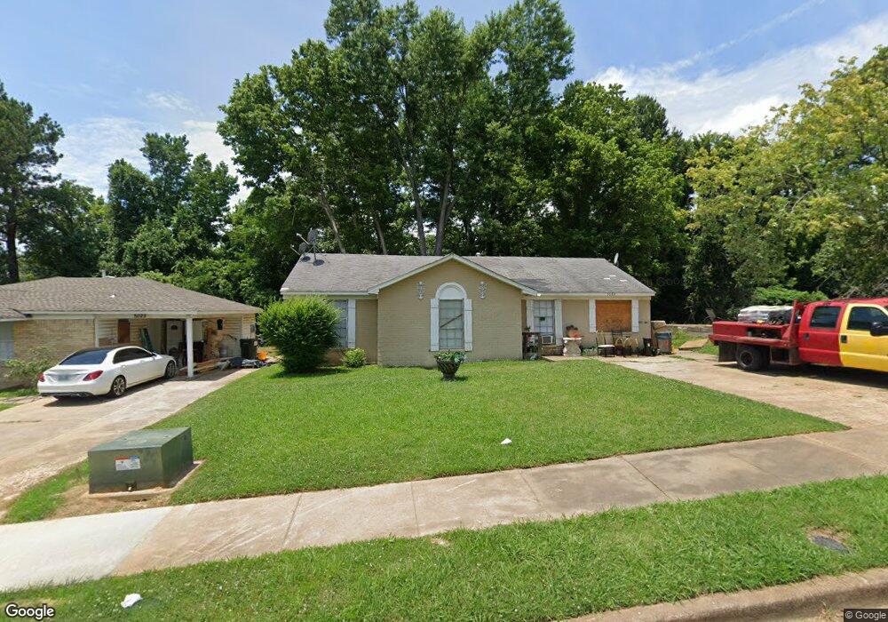
5033 Belfast Dr Memphis, TN 38127
Estimated Value: $85,000 - $100,000
4
Beds
2
Baths
1,248
Sq Ft
$73/Sq Ft
Est. Value
About This Home
This home is located at 5033 Belfast Dr, Memphis, TN 38127 and is currently estimated at $91,441, approximately $73 per square foot. 5033 Belfast Dr is a home located in Shelby County with nearby schools including Northaven Elementary School, Woodstock Middle School, and Trezevant High School.
Ownership History
Date
Name
Owned For
Owner Type
Purchase Details
Closed on
Jul 9, 2009
Sold by
Bishop Joseph
Bought by
Bailey Lois
Current Estimated Value
Purchase Details
Closed on
Jun 26, 2008
Sold by
Novastar Mortgage Inc
Bought by
Bishop Joseph
Purchase Details
Closed on
Apr 24, 2008
Sold by
Williamson Mary A
Bought by
Novastar Mortgage Inc
Purchase Details
Closed on
Oct 6, 1999
Sold by
Fearnley Michael A and Fearnley Miriam H
Bought by
Carter Winston Timothy and Carter Nancy G
Home Financials for this Owner
Home Financials are based on the most recent Mortgage that was taken out on this home.
Original Mortgage
$46,550
Interest Rate
7.91%
Create a Home Valuation Report for This Property
The Home Valuation Report is an in-depth analysis detailing your home's value as well as a comparison with similar homes in the area
Home Values in the Area
Average Home Value in this Area
Purchase History
| Date | Buyer | Sale Price | Title Company |
|---|---|---|---|
| Bailey Lois | -- | None Available | |
| Bishop Joseph | $11,000 | None Available | |
| Novastar Mortgage Inc | $34,000 | None Available | |
| Carter Winston Timothy | -- | -- | |
| Williamson Mary A | $48,000 | -- |
Source: Public Records
Mortgage History
| Date | Status | Borrower | Loan Amount |
|---|---|---|---|
| Previous Owner | Williamson Mary A | $46,550 |
Source: Public Records
Tax History Compared to Growth
Tax History
| Year | Tax Paid | Tax Assessment Tax Assessment Total Assessment is a certain percentage of the fair market value that is determined by local assessors to be the total taxable value of land and additions on the property. | Land | Improvement |
|---|---|---|---|---|
| 2025 | $439 | $22,150 | $2,000 | $20,150 |
| 2024 | $439 | $12,950 | $1,475 | $11,475 |
| 2023 | $439 | $12,950 | $1,475 | $11,475 |
| 2022 | $439 | $12,950 | $1,475 | $11,475 |
| 2021 | $447 | $12,950 | $1,475 | $11,475 |
| 2020 | $352 | $8,700 | $1,475 | $7,225 |
| 2019 | $352 | $8,700 | $1,475 | $7,225 |
| 2018 | $352 | $8,700 | $1,475 | $7,225 |
| 2017 | $358 | $8,700 | $1,475 | $7,225 |
| 2016 | $427 | $9,775 | $0 | $0 |
| 2014 | $427 | $9,775 | $0 | $0 |
Source: Public Records
Map
Nearby Homes
- 901 Chesterton Dr
- 5090 Belfast Dr
- 5096 Belfast Dr
- 850 Carol Ann Cove
- 5072 Blacksmith Dr
- 936 Chesterton Dr
- 5088 Breckenwood Dr
- 810 Northaven Dr
- 980 N Circle Rd
- 5030 Breckenwood Dr
- 5046 Breckenwood Dr
- 881 Northaven Dr
- 5140 Blacksmith Dr
- 706 Northaven Dr
- 759 Brandywine Blvd
- 823 Bitter Creek Cove
- 645 Mcwhirter Ave
- 635 Mcwhirter Ave
- 5315 Braden Dr
- 4710 E Circle Rd
- 5039 Belfast Dr
- 5025 Belfast Dr
- 5043 Belfast Dr
- 5032 Belfast Dr
- 5038 Belfast Dr
- 5049 Belfast Dr
- 5024 Belfast Dr
- 5042 Belfast Dr
- 5055 Belfast Dr
- 5048 Belfast Dr
- 5054 Belfast Dr
- 5061 Belfast Dr
- 883 Chesterton Dr
- 5047 Carterville Place
- 5060 Belfast Dr
- 5053 Carterville Place
- 5059 Carterville Place
- 5066 Belfast Dr
- 5034 Bowdoin Dr
- 889 Chesterton Dr