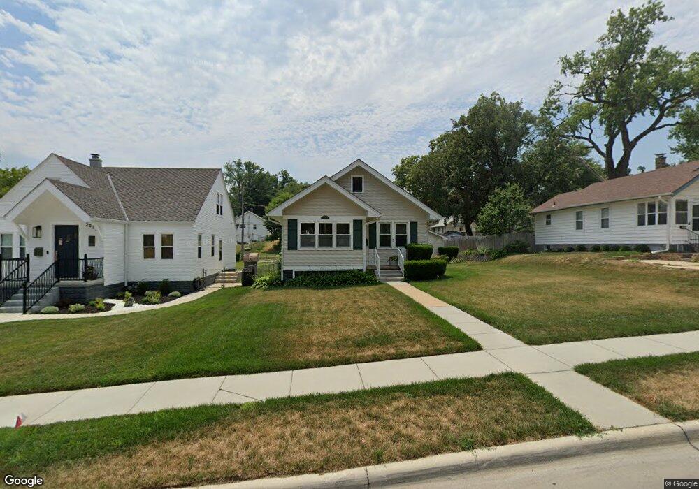
5039 Maple St Omaha, NE 68104
North Omaha NeighborhoodEstimated Value: $175,000 - $261,000
2
Beds
2
Baths
952
Sq Ft
$221/Sq Ft
Est. Value
About This Home
This home is located at 5039 Maple St, Omaha, NE 68104 and is currently estimated at $210,112, approximately $220 per square foot. 5039 Maple St is a home located in Douglas County with nearby schools including Rose Hill Elementary School, Monroe Middle School, and Benson Magnet High School.
Ownership History
Date
Name
Owned For
Owner Type
Purchase Details
Closed on
Jun 21, 2024
Sold by
Callender John Craig and Terasa Suvonne
Bought by
John Craig Callender Revocable Trust and Terasa Callender Revocable Trust
Current Estimated Value
Home Financials for this Owner
Home Financials are based on the most recent Mortgage that was taken out on this home.
Original Mortgage
$166,870
Interest Rate
6.73%
Mortgage Type
FHA
Purchase Details
Closed on
May 9, 2024
Sold by
Callender John C and Callender Terasa S
Bought by
John Callender Revocable Trust and Terasa Callender Revocable Trust
Home Financials for this Owner
Home Financials are based on the most recent Mortgage that was taken out on this home.
Original Mortgage
$166,870
Interest Rate
6.73%
Mortgage Type
FHA
Create a Home Valuation Report for This Property
The Home Valuation Report is an in-depth analysis detailing your home's value as well as a comparison with similar homes in the area
Home Values in the Area
Average Home Value in this Area
Purchase History
| Date | Buyer | Sale Price | Title Company |
|---|---|---|---|
| John Craig Callender Revocable Trust | $1,777 | None Listed On Document | |
| Callender John Craig | $2,222 | None Listed On Document | |
| John Callender Revocable Trust | -- | None Listed On Document |
Source: Public Records
Mortgage History
| Date | Status | Borrower | Loan Amount |
|---|---|---|---|
| Previous Owner | Callender John Craig | $166,870 |
Source: Public Records
Tax History
| Year | Tax Paid | Tax Assessment Tax Assessment Total Assessment is a certain percentage of the fair market value that is determined by local assessors to be the total taxable value of land and additions on the property. | Land | Improvement |
|---|---|---|---|---|
| 2025 | $1,222 | $183,600 | $20,900 | $162,700 |
| 2024 | $2,196 | $152,100 | $20,900 | $131,200 |
| 2023 | $2,196 | $152,100 | $20,900 | $131,200 |
| 2022 | $427 | $124,900 | $20,900 | $104,000 |
| 2021 | $2,088 | $124,900 | $20,900 | $104,000 |
| 2020 | $2,289 | $106,900 | $20,900 | $86,000 |
| 2019 | $2,201 | $102,500 | $900 | $101,600 |
| 2018 | $1,830 | $85,100 | $900 | $84,200 |
| 2017 | $1,478 | $68,400 | $7,000 | $61,400 |
| 2016 | $1,468 | $68,400 | $7,000 | $61,400 |
Source: Public Records
Map
Nearby Homes
- 5044 Corby St
- 2812 N 51st St
- 2611 N 51st Ave
- 2510 N 51st St
- 5322 Corby St Unit 11
- 4955 Bedford Ave
- 2533 N 49th St
- 2701 Country Club Ave
- 5006 Bedford Ave
- 2717 N 48th Ave
- 2760 N 48th St
- 2408 N 49th St
- 2724 N 47th Ave
- 3408 N 49th St
- 5519 NW Radial Hwy
- 2728 Fontenelle Blvd
- 2916 Fontenelle Blvd
- 2019 N 50th Ave
- 2944 N 56th St
- 2520 N 56th St
Your Personal Tour Guide
Ask me questions while you tour the home.