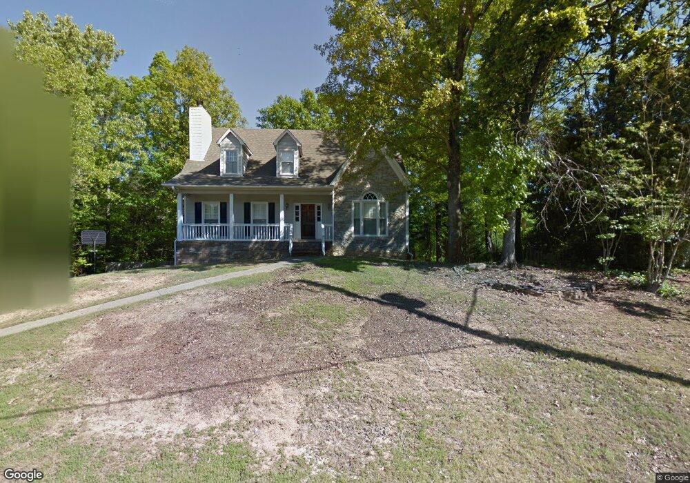
505 S Fork Ln Birmingham, AL 35244
Estimated Value: $395,710 - $440,000
3
Beds
2
Baths
2,974
Sq Ft
$138/Sq Ft
Est. Value
About This Home
This home is located at 505 S Fork Ln, Birmingham, AL 35244 and is currently estimated at $411,678, approximately $138 per square foot. 505 S Fork Ln is a home located in Jefferson County with nearby schools including South Shades Crest Elementary School, Brock's Gap Intermediate School, and Robert F. Bumpus Middle School.
Ownership History
Date
Name
Owned For
Owner Type
Purchase Details
Closed on
Aug 31, 2001
Sold by
Battle Frank K and Battle Janice J
Bought by
White William S and White Chris H
Current Estimated Value
Home Financials for this Owner
Home Financials are based on the most recent Mortgage that was taken out on this home.
Original Mortgage
$163,200
Interest Rate
6.87%
Create a Home Valuation Report for This Property
The Home Valuation Report is an in-depth analysis detailing your home's value as well as a comparison with similar homes in the area
Home Values in the Area
Average Home Value in this Area
Purchase History
| Date | Buyer | Sale Price | Title Company |
|---|---|---|---|
| White William S | $204,000 | -- |
Source: Public Records
Mortgage History
| Date | Status | Borrower | Loan Amount |
|---|---|---|---|
| Previous Owner | White William S | $163,200 | |
| Closed | White William S | $20,400 |
Source: Public Records
Tax History Compared to Growth
Tax History
| Year | Tax Paid | Tax Assessment Tax Assessment Total Assessment is a certain percentage of the fair market value that is determined by local assessors to be the total taxable value of land and additions on the property. | Land | Improvement |
|---|---|---|---|---|
| 2024 | $2,624 | $36,880 | -- | -- |
| 2022 | $2,293 | $32,310 | $8,000 | $24,310 |
| 2021 | $1,977 | $27,960 | $8,000 | $19,960 |
| 2020 | $1,798 | $25,350 | $8,000 | $17,350 |
| 2019 | $1,788 | $25,360 | $0 | $0 |
| 2018 | $1,671 | $23,740 | $0 | $0 |
| 2017 | $1,671 | $23,740 | $0 | $0 |
| 2016 | $1,657 | $23,560 | $0 | $0 |
| 2015 | $1,657 | $23,560 | $0 | $0 |
| 2014 | $1,685 | $23,220 | $0 | $0 |
| 2013 | $1,685 | $23,220 | $0 | $0 |
Source: Public Records
Map
Nearby Homes
- 600 Southdale Ln
- 1521 Cypress Cove Cir
- 5911 Peachwood Cir
- 205 Russet Woods Dr
- 230 Russet Woods Dr
- 404 Russet Hollow Rd
- 127 Top O Tree Ln
- 413 Russet Hill Rd
- 5524 Lake Cyrus Ln
- 5527 Lake Cyrus Ln
- 1916 Strawberry Ln
- 1912 High Ridge Cir
- 1860 Russet Hill Cir
- 3965 S Shades Crest Rd
- 5960 Waterscape Pass
- 5808 Willow Lake Dr
- 6200 Shades Pointe Ln
- 5569 Park Side Cir
- 5536 Park Side Cir
- 600 Crest View Cir
- 509 S Fork Ln
- 5985 S Fork Dr
- 506 S Fork Ln
- 704 Southdale Cir
- 708 Southdale Cir
- 513 S Fork Ln
- 5993 S Fork Dr
- 510 S Fork Ln
- 700 Southdale Cir
- 714 Southdale Cir
- 517 S Fork Ln
- 514 S Fork Ln
- 5988 S Fork Dr
- 5984 S Fork Dr
- 718 Southdale Cir
- 5999 S Fork Dr
- 413 S Fork Cir
- 608 Southdale Ln
- 5992 S Fork Dr
- 705 Southdale Cir