Estimated Value: $73,000 - $110,000
--
Bed
1
Bath
616
Sq Ft
$146/Sq Ft
Est. Value
About This Home
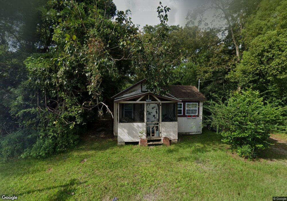
This home is located at 505 W Poplar St, Jesup, GA 31545 and is currently estimated at $90,033, approximately $146 per square foot. 505 W Poplar St is a home located in Wayne County with nearby schools including Martha Rawls Smith Elementary School, Martha Puckett Middle School, and Wayne County High School.
Ownership History
Date
Name
Owned For
Owner Type
Purchase Details
Closed on
Jan 3, 2012
Sold by
Hayes Emma Richardson
Bought by
Harris Michael J
Current Estimated Value
Purchase Details
Closed on
Aug 10, 2008
Sold by
Hopkins Bernie
Bought by
Hayes Emma Jean
Purchase Details
Closed on
Feb 1, 2001
Purchase Details
Closed on
Oct 1, 1999
Purchase Details
Closed on
Jul 1, 1995
Purchase Details
Closed on
Apr 1, 1992
Purchase Details
Closed on
Mar 1, 1992
Purchase Details
Closed on
Jan 1, 1982
Purchase Details
Closed on
Jun 1, 1981
Purchase Details
Closed on
Jul 1, 1957
Create a Home Valuation Report for This Property
The Home Valuation Report is an in-depth analysis detailing your home's value as well as a comparison with similar homes in the area
Home Values in the Area
Average Home Value in this Area
Purchase History
| Date | Buyer | Sale Price | Title Company |
|---|---|---|---|
| Harris Michael J | -- | -- | |
| Harris Michael J | -- | -- | |
| Hayes Emma Jean | -- | -- | |
| -- | -- | -- | |
| -- | $14,000 | -- | |
| -- | -- | -- | |
| -- | $6,000 | -- | |
| -- | $42,000 | -- | |
| -- | -- | -- | |
| -- | -- | -- | |
| -- | -- | -- |
Source: Public Records
Tax History Compared to Growth
Tax History
| Year | Tax Paid | Tax Assessment Tax Assessment Total Assessment is a certain percentage of the fair market value that is determined by local assessors to be the total taxable value of land and additions on the property. | Land | Improvement |
|---|---|---|---|---|
| 2024 | $425 | $13,894 | $2,500 | $11,394 |
| 2023 | $260 | $8,845 | $2,460 | $6,385 |
| 2022 | $278 | $8,845 | $2,460 | $6,385 |
| 2021 | $298 | $8,845 | $2,460 | $6,385 |
| 2020 | $309 | $8,845 | $2,460 | $6,385 |
| 2019 | $318 | $8,845 | $2,460 | $6,385 |
| 2018 | $318 | $8,845 | $2,460 | $6,385 |
| 2017 | $274 | $8,845 | $2,460 | $6,385 |
| 2016 | $265 | $8,845 | $2,460 | $6,385 |
| 2014 | $265 | $8,845 | $2,460 | $6,385 |
| 2013 | -- | $8,844 | $2,460 | $6,384 |
Source: Public Records
Map
Nearby Homes
- 0000 N Fourth St
- 0 N Fourth St Unit 159403
- 0 N Fourth St Unit 1652040
- 0 N 3rd Ln
- 356 N 4th St
- 356 N Fourth St
- 0 N 4th St
- 0 N 4th St Unit 10414401
- 344 N Fourth St
- 0 U S 84
- 447 NE Broad St
- 196 Pine Ridge Dr
- 197 NW Broad St
- 498 NE Broad St
- 436-441 Brunswick St
- 9474 Us Hwy 301
- 106 Mangrove Ct
- 113 Mangrove Ct
- 00 84 Hwy
- 207 E Pine St