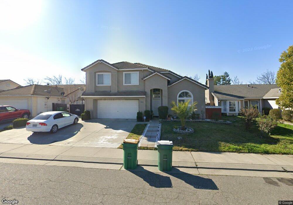
5062 Kimball Hill Cir Stockton, CA 95210
Estimated Value: $288,000 - $577,000
4
Beds
4
Baths
2,622
Sq Ft
$177/Sq Ft
Est. Value
About This Home
This home is located at 5062 Kimball Hill Cir, Stockton, CA 95210 and is currently estimated at $464,799, approximately $177 per square foot. 5062 Kimball Hill Cir is a home located in San Joaquin County with nearby schools including Rio Calaveras Elementary School, George W. Bush Elementary School, and Valentine Peyton Elementary School.
Ownership History
Date
Name
Owned For
Owner Type
Purchase Details
Closed on
Dec 18, 2018
Sold by
Kaur Balvir
Bought by
Kaur Balvir and Balvir Kaur Declaration Of Tru
Current Estimated Value
Purchase Details
Closed on
Jan 6, 1999
Sold by
Kimball Hill Homes California Inc
Bought by
Mann Jagatjit S and Kaur Balvir
Home Financials for this Owner
Home Financials are based on the most recent Mortgage that was taken out on this home.
Original Mortgage
$117,600
Interest Rate
6.73%
Create a Home Valuation Report for This Property
The Home Valuation Report is an in-depth analysis detailing your home's value as well as a comparison with similar homes in the area
Home Values in the Area
Average Home Value in this Area
Purchase History
| Date | Buyer | Sale Price | Title Company |
|---|---|---|---|
| Kaur Balvir | -- | None Available | |
| Mann Jagatjit S | $147,500 | Chicago Title Co |
Source: Public Records
Mortgage History
| Date | Status | Borrower | Loan Amount |
|---|---|---|---|
| Closed | Mann Jagatjit S | $117,600 |
Source: Public Records
Tax History Compared to Growth
Tax History
| Year | Tax Paid | Tax Assessment Tax Assessment Total Assessment is a certain percentage of the fair market value that is determined by local assessors to be the total taxable value of land and additions on the property. | Land | Improvement |
|---|---|---|---|---|
| 2025 | $2,830 | $230,447 | $54,863 | $175,584 |
| 2024 | $2,784 | $225,930 | $53,788 | $172,142 |
| 2023 | $2,721 | $221,501 | $52,734 | $168,767 |
| 2022 | $2,672 | $217,158 | $51,700 | $165,458 |
| 2021 | $2,567 | $212,901 | $50,687 | $162,214 |
| 2020 | $2,616 | $210,719 | $50,168 | $160,551 |
| 2019 | $2,604 | $206,588 | $49,185 | $157,403 |
| 2018 | $2,555 | $202,538 | $48,221 | $154,317 |
| 2017 | $2,421 | $198,568 | $47,276 | $151,292 |
| 2016 | $2,463 | $194,675 | $46,349 | $148,326 |
| 2014 | $2,342 | $187,996 | $44,759 | $143,237 |
Source: Public Records
Map
Nearby Homes
- 1750 Bonaire Cir
- 1608 Bonaire Cir
- 2321 Bartram Run Way
- 4705 Cayman Ct
- 5271 Barbados Cir
- 4503 White Forge Dr
- 4437 Harmony Hill Way
- 2330 Pinetown St
- 5431 Strawberry Way
- 2709 Etcheverry Dr
- 4450 Oakfield Dr
- 4720 Greensboro Way
- 5250 Foxglove Ct
- 4028 Trieste Cir
- 5816 Caribbean Cir
- 5813 Fred Russo Dr
- 5718 Krissi Ct
- 4718 Hillsboro Way
- 5831 Caribbean Cir
- 4463 Townehome Dr
- 5056 Kimball Hill Cir
- 5070 Kimball Hill Cir
- 5078 Kimball Hill Cir
- 5050 Kimball Hill Cir
- 5067 Kimball Hill Cir
- 5059 Kimball Hill Cir
- 5084 Kimball Hill Cir
- 5044 Kimball Hill Cir
- 5073 Kimball Hill Cir
- 5055 Kimball Hill Cir
- 2003 Tennalinde Ln
- 5049 Kimball Hill Cir
- 5038 Kimball Hill Cir
- 2106 Greenan Ct
- 2015 Tennalinde Ln
- 2107 Greenan Ct
- 5013 Kimball Hill Cir
- 2027 Tennalinde Ln
- 5032 Kimball Hill Cir
- 5009 Kimball Hill Cir