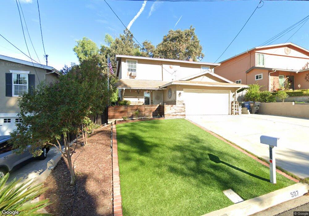
507 Benson Way Thousand Oaks, CA 91360
Estimated Value: $856,788 - $1,036,000
4
Beds
3
Baths
1,685
Sq Ft
$570/Sq Ft
Est. Value
About This Home
This home is located at 507 Benson Way, Thousand Oaks, CA 91360 and is currently estimated at $960,447, approximately $569 per square foot. 507 Benson Way is a home located in Ventura County with nearby schools including Glenwood Elementary School, Colina Middle School, and Westlake High School.
Ownership History
Date
Name
Owned For
Owner Type
Purchase Details
Closed on
Feb 9, 2004
Sold by
Davis Shaun Robert
Bought by
Davis Shaun Robert and Davis Lauren E
Current Estimated Value
Home Financials for this Owner
Home Financials are based on the most recent Mortgage that was taken out on this home.
Original Mortgage
$150,000
Interest Rate
5.85%
Mortgage Type
New Conventional
Purchase Details
Closed on
Jul 25, 1998
Sold by
Parthum Wayne E
Bought by
Davis Shaun Robert
Home Financials for this Owner
Home Financials are based on the most recent Mortgage that was taken out on this home.
Original Mortgage
$127,500
Interest Rate
6.89%
Purchase Details
Closed on
Dec 4, 1996
Sold by
Harvey Family and James C
Bought by
Zita Dennis
Home Financials for this Owner
Home Financials are based on the most recent Mortgage that was taken out on this home.
Original Mortgage
$110,000
Interest Rate
6.65%
Create a Home Valuation Report for This Property
The Home Valuation Report is an in-depth analysis detailing your home's value as well as a comparison with similar homes in the area
Purchase History
| Date | Buyer | Sale Price | Title Company |
|---|---|---|---|
| Davis Shaun Robert | -- | Fidelity National Title Co | |
| Davis Shaun Robert | $170,000 | Stewart Title | |
| Zita Dennis | $140,000 | United Title Company |
Source: Public Records
Mortgage History
| Date | Status | Borrower | Loan Amount |
|---|---|---|---|
| Closed | Davis Shaun Robert | $150,000 | |
| Previous Owner | Davis Shaun Robert | $127,500 | |
| Previous Owner | Zita Dennis | $110,000 |
Source: Public Records
Tax History Compared to Growth
Tax History
| Year | Tax Paid | Tax Assessment Tax Assessment Total Assessment is a certain percentage of the fair market value that is determined by local assessors to be the total taxable value of land and additions on the property. | Land | Improvement |
|---|---|---|---|---|
| 2025 | $3,252 | $266,482 | $195,951 | $70,531 |
| 2024 | $3,252 | $261,257 | $192,108 | $69,149 |
| 2023 | $3,140 | $256,135 | $188,341 | $67,794 |
| 2022 | $3,083 | $251,113 | $184,648 | $66,465 |
| 2021 | $3,028 | $246,190 | $181,028 | $65,162 |
| 2020 | $2,635 | $243,668 | $179,173 | $64,495 |
| 2019 | $2,566 | $238,891 | $175,660 | $63,231 |
| 2018 | $2,515 | $234,208 | $172,216 | $61,992 |
| 2017 | $2,467 | $229,617 | $168,840 | $60,777 |
| 2016 | $2,444 | $225,116 | $165,530 | $59,586 |
| 2015 | $2,402 | $221,737 | $163,045 | $58,692 |
| 2014 | $2,368 | $217,396 | $159,852 | $57,544 |
Source: Public Records
Map
Nearby Homes
- 714 Brossard Dr
- 628 Paige Ln
- 764 Brossard Dr
- 515 Houston Dr
- 1113 Buckingham Dr
- 123 Mayflower St
- 1346 E Hillcrest Dr Unit 49
- 0 Rimrock Unit SR25274785
- 21 Westbury St
- 146 Maegan Place Unit 9
- 1324 La Granada Dr
- 68 Maegan Place Unit 7
- 224 Oakleaf Dr Unit 105
- 224 Oakleaf Dr Unit 102
- 231 Green Lea Place
- 245 Oakleaf Dr Unit 205
- 201 Green Heath Place
- 248 Oakleaf Dr Unit 107
- 282 Green Moor Place
- 291 Sequoia Ct Unit 31
- 529 Benson Way
- 505 Benson Way
- 440 Wilbur Ct
- 390 Flittner Cir
- 543 Benson Way
- 460 Wilbur Ct
- 401 Flittner Cir
- 540 Benson Way
- 378 Flittner Cir
- 555 Benson Way
- 0 Hodencamp Rd
- 387 Flittner Cir
- 546 Benson Way
- 322 Hodencamp Rd
- 550 Benson Way
- 366 Flittner Cir
- 567 Benson Way
- 373 Flittner Cir
- 455 Wilbur Ct
- 468 Wilbur Ct