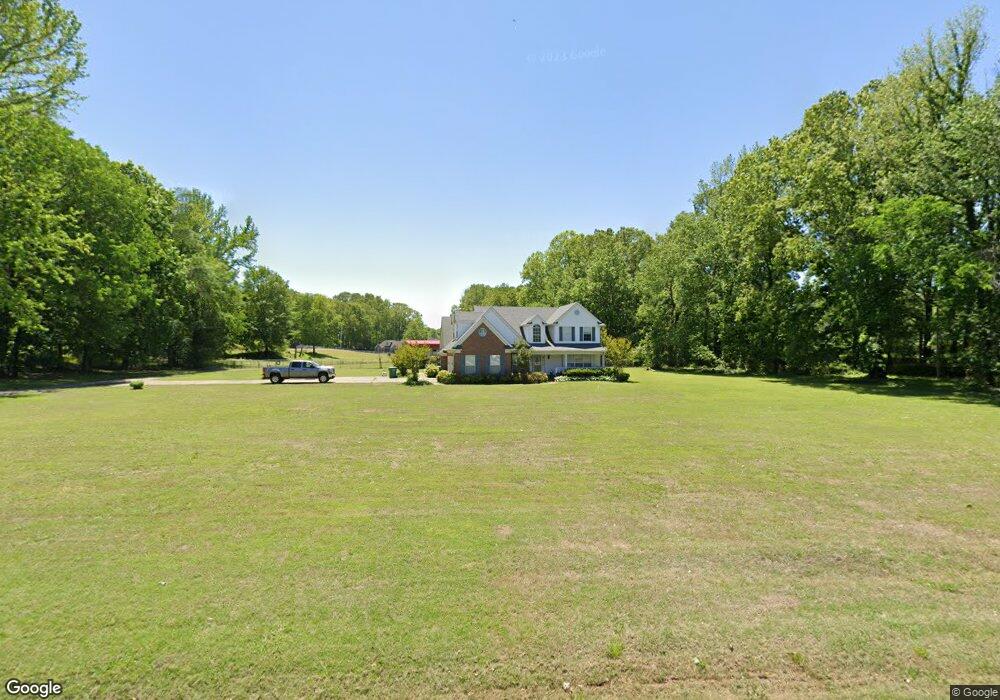
5075 Allen Rd Hernando, MS 38632
Lewisburg NeighborhoodEstimated Value: $491,000 - $642,000
4
Beds
4
Baths
3,200
Sq Ft
$172/Sq Ft
Est. Value
About This Home
This home is located at 5075 Allen Rd, Hernando, MS 38632 and is currently estimated at $551,498, approximately $172 per square foot. 5075 Allen Rd is a home located in DeSoto County with nearby schools including Lewisburg Primary School, Lewisburg Elementary School, and Lewisburg Middle School.
Ownership History
Date
Name
Owned For
Owner Type
Purchase Details
Closed on
Aug 29, 2014
Sold by
Hall William L and Hall Lisa W
Bought by
Candy Jack H and Candy Melissa A
Current Estimated Value
Home Financials for this Owner
Home Financials are based on the most recent Mortgage that was taken out on this home.
Original Mortgage
$265,525
Outstanding Balance
$201,888
Interest Rate
4.19%
Mortgage Type
New Conventional
Estimated Equity
$349,610
Purchase Details
Closed on
Aug 15, 2013
Sold by
Brentway Investments
Bought by
Hall William L and Hall Lisa W
Create a Home Valuation Report for This Property
The Home Valuation Report is an in-depth analysis detailing your home's value as well as a comparison with similar homes in the area
Home Values in the Area
Average Home Value in this Area
Purchase History
| Date | Buyer | Sale Price | Title Company |
|---|---|---|---|
| Candy Jack H | -- | None Available | |
| Hall William L | -- | None Available |
Source: Public Records
Mortgage History
| Date | Status | Borrower | Loan Amount |
|---|---|---|---|
| Open | Candy Jack H | $265,525 |
Source: Public Records
Tax History
| Year | Tax Paid | Tax Assessment Tax Assessment Total Assessment is a certain percentage of the fair market value that is determined by local assessors to be the total taxable value of land and additions on the property. | Land | Improvement |
|---|---|---|---|---|
| 2025 | $2,437 | $33,185 | $3,000 | $30,185 |
| 2024 | $2,057 | $23,570 | $3,000 | $20,570 |
| 2023 | $2,057 | $23,570 | $0 | $0 |
| 2022 | $2,057 | $23,570 | $3,000 | $20,570 |
| 2021 | $2,057 | $23,570 | $3,000 | $20,570 |
| 2020 | $1,889 | $21,897 | $3,000 | $18,897 |
| 2019 | $1,889 | $21,897 | $3,000 | $18,897 |
| 2017 | $1,854 | $39,774 | $21,387 | $18,387 |
| 2016 | $1,854 | $21,387 | $3,000 | $18,387 |
| 2015 | $2,154 | $39,774 | $21,387 | $18,387 |
| 2014 | $2,154 | $21,387 | $0 | $0 |
| 2013 | $1,507 | $21,387 | $0 | $0 |
Source: Public Records
Map
Nearby Homes
- 5000 Allen Rd
- 10756 Honey Ridge Dr
- 0 Hunters Walk Unit 4124365
- 5905 Allen Rd
- 4348 Mississippi 305
- 10094 Sunset Creek Dr
- 9338 Hudson Rd
- 4644 Taylor Trail
- 4677 Taylor Trail
- 9092 Bennett Trail
- 9069 Bennett Trail
- 9072 Treadway Creek
- 9065 Bennett Trail
- 9002 Lot 3 Hudson Rd
- 9002 Lot 2 Hudson Rd
- 4121 Jenny Ln
- 5641 Rock Creek
- 8600 County Line Rd
- 667 Red Banks Rd
- 707 Pigeon Roost Rd
- 5078 Dixie Creek Dr
- 10856 Brentway Cove
- 3 Brentway Cove
- 10802 Brentway Cove
- 10867 Brentway Cove
- 5071 Dixie Creek Dr
- 10821 Brentway Cove
- 5123 Dixie Creek Dr
- 10735 Fox Glen Dr
- 5170 Dixie Creek Dr
- 10799 Brentway Cove
- 5009 Allen Rd
- 5217 Allen Rd
- 5060 Allen Rd
- 5008 Allen Rd
- 1 Dixie Creek Dr
- 10730 Fox Glen Dr
- 5171 Dixie Creek Dr
- 5006 Allen Rd
- 5007 Allen Rd
Your Personal Tour Guide
Ask me questions while you tour the home.