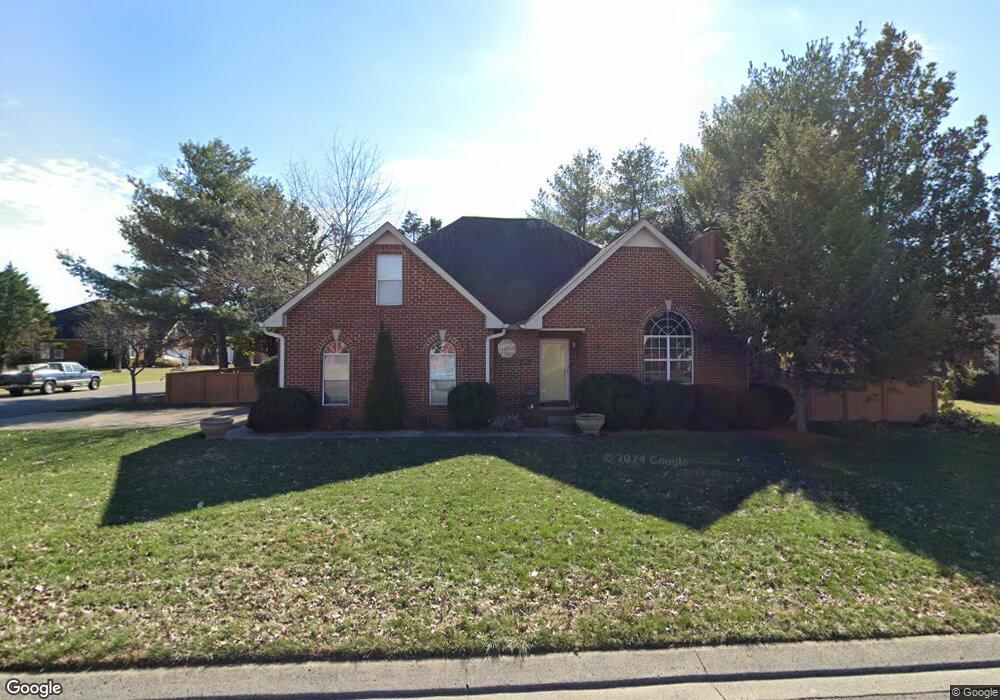
508 Forrest Pointe Dr Murfreesboro, TN 37130
Estimated Value: $380,351 - $458,000
Studio
3
Baths
2,034
Sq Ft
$213/Sq Ft
Est. Value
About This Home
This home is located at 508 Forrest Pointe Dr, Murfreesboro, TN 37130 and is currently estimated at $432,588, approximately $212 per square foot. 508 Forrest Pointe Dr is a home located in Rutherford County with nearby schools including Black Fox Elementary School, Christiana Middle School, and Riverdale High School.
Ownership History
Date
Name
Owned For
Owner Type
Purchase Details
Closed on
Oct 25, 2006
Sold by
Mifflin Robert B
Bought by
Crass and Kristi
Current Estimated Value
Home Financials for this Owner
Home Financials are based on the most recent Mortgage that was taken out on this home.
Original Mortgage
$151,920
Outstanding Balance
$90,164
Interest Rate
6.27%
Estimated Equity
$342,424
Purchase Details
Closed on
Aug 18, 1994
Sold by
Landmark Homes Of Tenn
Bought by
Mifflin Robert B
Purchase Details
Closed on
Apr 5, 1994
Sold by
Forrest Partnership
Bought by
Landmark Homes Of Tn Inc
Create a Home Valuation Report for This Property
The Home Valuation Report is an in-depth analysis detailing your home's value as well as a comparison with similar homes in the area
Home Values in the Area
Average Home Value in this Area
Purchase History
| Date | Buyer | Sale Price | Title Company |
|---|---|---|---|
| Crass | $189,900 | -- | |
| Mifflin Robert B | -- | -- | |
| Landmark Homes Of Tn Inc | $16,900 | -- |
Source: Public Records
Mortgage History
| Date | Status | Borrower | Loan Amount |
|---|---|---|---|
| Open | Landmark Homes Of Tn Inc | $151,920 |
Source: Public Records
Tax History
| Year | Tax Paid | Tax Assessment Tax Assessment Total Assessment is a certain percentage of the fair market value that is determined by local assessors to be the total taxable value of land and additions on the property. | Land | Improvement |
|---|---|---|---|---|
| 2025 | -- | $84,200 | $13,750 | $70,450 |
| 2024 | $2,382 | $84,200 | $13,750 | $70,450 |
| 2023 | $1,580 | $84,200 | $13,750 | $70,450 |
| 2022 | $1,361 | $84,200 | $13,750 | $70,450 |
| 2021 | $1,266 | $57,025 | $10,625 | $46,400 |
| 2020 | $1,266 | $57,025 | $10,625 | $46,400 |
| 2019 | $1,266 | $57,025 | $10,625 | $46,400 |
| 2018 | $1,738 | $57,025 | $0 | $0 |
| 2017 | $1,816 | $46,725 | $0 | $0 |
| 2016 | $1,816 | $46,725 | $0 | $0 |
| 2015 | $1,816 | $46,725 | $0 | $0 |
| 2014 | $1,162 | $46,725 | $0 | $0 |
| 2013 | -- | $44,275 | $0 | $0 |
Source: Public Records
Map
Nearby Homes
- 1545 Nathan Ct
- 1330 Shearron Ct
- 1341 Shearron Ct
- 1119 Walton Dr
- 1280 Middle Tennessee Blvd Unit B5
- 1280 Middle Tennessee Blvd Unit B14
- 1103 Virginia Ave
- 1010 Silver Point Dr
- 1120 Toddington Dr Unit 1122
- 1002 Walton Dr
- 923 SE Broad St Unit 5
- 906 Kirkwood Ave
- 1023 Tyler Ct
- 1406 Bradyville Pike Unit 1408
- 1315 Bradyville Pike Unit 1
- 1315 Bradyville Pike Unit 2
- 1508 Laurel Ct
- 1307 Atlas St
- 609 S Highland Ave
- 1510 Foxdale Dr
- 1508 Boone Ct
- 502 Forrest Pointe Dr
- 514 Forrest Pointe Dr
- 1509 Nathan Ct
- 515 Forrest Pointe Dr
- 509 Forrest Pointe Dr
- 521 Forrest Pointe Dr
- 1514 Boone Ct
- 503 Forrest Pointe Dr
- 1509 Boone Ct
- 1515 Nathan Ct
- 520 Forrest Pointe Dr
- 527 Forrest Pointe Dr
- 432 Forrest Pointe Dr
- 1520 Boone Ct
- 433 Forrest Pointe Dr
- 1515 Boone Ct
- 533 Forrest Pointe Dr
- 1521 Nathan Ct
- 526 Forrest Pointe Dr
Your Personal Tour Guide
Ask me questions while you tour the home.