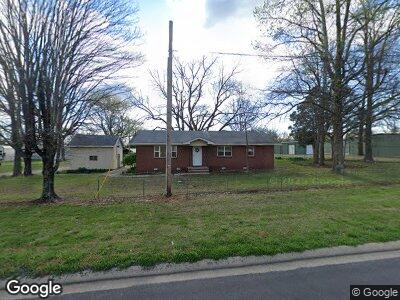
508 Highway 62 N Avoca, AR 72711
Avoca NeighborhoodEstimated Value: $204,960 - $239,000
--
Bed
1
Bath
2,420
Sq Ft
$92/Sq Ft
Est. Value
About This Home
This home is located at 508 Highway 62 N, Avoca, AR 72711 and is currently estimated at $222,653, approximately $92 per square foot. 508 Highway 62 N is a home located in Benton County with nearby schools including Grace Hill Elementary School, Oakdale Middle School, and Rogers Heritage High School.
Ownership History
Date
Name
Owned For
Owner Type
Purchase Details
Closed on
Sep 26, 2012
Sold by
Jump Robert Lee and Jump Eldon Ray
Bought by
Beaver Storage Llc
Current Estimated Value
Purchase Details
Closed on
Dec 13, 2011
Bought by
Dod 12 and Dod 13
Purchase Details
Closed on
Sep 1, 2005
Sold by
Jump Geraldine
Bought by
Bartell Fred and Bartell Margaret
Purchase Details
Closed on
Nov 1, 2001
Bought by
Ar St Hwy Comm
Purchase Details
Closed on
Dec 27, 1996
Bought by
Jump Tr
Purchase Details
Closed on
Nov 15, 1996
Bought by
Jump Living Trust
Purchase Details
Closed on
Sep 30, 1966
Bought by
Ash
Create a Home Valuation Report for This Property
The Home Valuation Report is an in-depth analysis detailing your home's value as well as a comparison with similar homes in the area
Home Values in the Area
Average Home Value in this Area
Purchase History
| Date | Buyer | Sale Price | Title Company |
|---|---|---|---|
| Beaver Storage Llc | $45,000 | Lenders Title Company | |
| Dod 12 | -- | -- | |
| Bartell Fred | $80,000 | Bartell Lenders Title Co | |
| Ar St Hwy Comm | -- | -- | |
| Jump Tr | -- | -- | |
| Jump Living Trust | -- | -- | |
| Ash | -- | -- |
Source: Public Records
Tax History Compared to Growth
Tax History
| Year | Tax Paid | Tax Assessment Tax Assessment Total Assessment is a certain percentage of the fair market value that is determined by local assessors to be the total taxable value of land and additions on the property. | Land | Improvement |
|---|---|---|---|---|
| 2024 | $1,060 | $32,779 | $10,000 | $22,779 |
| 2023 | $964 | $21,210 | $3,800 | $17,410 |
| 2022 | $1,100 | $21,210 | $3,800 | $17,410 |
| 2021 | $1,018 | $21,210 | $3,800 | $17,410 |
| 2020 | $940 | $13,950 | $1,500 | $12,450 |
| 2019 | $940 | $13,950 | $1,500 | $12,450 |
| 2018 | $940 | $13,950 | $1,500 | $12,450 |
| 2017 | $891 | $13,950 | $1,500 | $12,450 |
| 2016 | $891 | $13,950 | $1,500 | $12,450 |
| 2015 | $726 | $13,680 | $3,200 | $10,480 |
| 2014 | $876 | $13,680 | $3,200 | $10,480 |
Source: Public Records
Map
Nearby Homes
- 366 Sheppard Rd
- 469 Sheppard Rd
- 0 N Hwy 62 Unit 1148836
- 0 Rader Rd Unit 1290308
- Lot 26 Red Cedar Place
- Lot 25 Red Cedar Place
- 969 Rader Rd
- 948 Red Cedar Place
- 924 Red Cedar Place
- 917 Red Cedar Place
- 925 Red Cedar Place
- 933 Red Cedar Place
- 940 Red Cedar Place
- 949 Red Cedar Place
- 941 Red Cedar Place
- Lot 11 Red Cedar Place
- 959 Nadine Dr
- 988 Red Cedar Place
- 981 Red Cedar Place
- 973 Red Cedar Place
- 508 Highway 62 N
- 483 N Hwy 62
- 487 S Hwy 62
- 489 S Hwy 62
- 459 N Highway 62
- 230 Blevins Ln
- 230 Blevins Ln
- 525 N Highway 62
- 525 N Hwy 62
- 500 Russell Rd
- 0 Highway 62 Unit 7 1242266
- 0 Highway 62 Unit 9 1242264
- 0 Highway 62 Unit 10 1242242
- 0 Highway 62 Unit 1242273
- 0 Highway 62 Unit 1242264
- 0 Highway 62 Unit 1242266
- 0 Highway 62 Unit 1242270
- 0 Highway 62 Unit 1242272
- 0 Highway 62 Unit 1242242
- 0 Highway 62 Unit 1031285