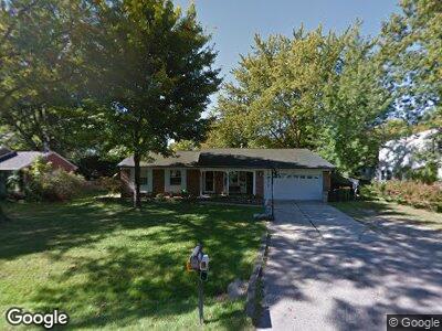
50831 Miner St New Baltimore, MI 48047
Estimated Value: $231,905 - $323,000
--
Bed
2
Baths
1,383
Sq Ft
$198/Sq Ft
Est. Value
About This Home
This home is located at 50831 Miner St, New Baltimore, MI 48047 and is currently estimated at $274,226, approximately $198 per square foot. 50831 Miner St is a home located in Macomb County with nearby schools including Lighthouse Elementary School, Anchor Bay Middle School North, and Anchor Bay High School.
Ownership History
Date
Name
Owned For
Owner Type
Purchase Details
Closed on
Oct 13, 2020
Sold by
Mann Scott and Mann Serena
Bought by
Mann Scott and Mann Serena
Current Estimated Value
Home Financials for this Owner
Home Financials are based on the most recent Mortgage that was taken out on this home.
Original Mortgage
$107,500
Outstanding Balance
$79,203
Interest Rate
2.4%
Mortgage Type
New Conventional
Estimated Equity
$190,568
Purchase Details
Closed on
Oct 11, 2000
Sold by
Figlan Kenneth E
Bought by
Mann Scott
Create a Home Valuation Report for This Property
The Home Valuation Report is an in-depth analysis detailing your home's value as well as a comparison with similar homes in the area
Home Values in the Area
Average Home Value in this Area
Purchase History
| Date | Buyer | Sale Price | Title Company |
|---|---|---|---|
| Mann Scott | -- | None Available | |
| Mann Scott | -- | None Listed On Document | |
| Mann Scott | $147,900 | -- |
Source: Public Records
Mortgage History
| Date | Status | Borrower | Loan Amount |
|---|---|---|---|
| Open | Mann Scott | $107,500 | |
| Closed | Mann Scott | $107,500 | |
| Previous Owner | Adamski Serena M | $129,669 |
Source: Public Records
Tax History Compared to Growth
Tax History
| Year | Tax Paid | Tax Assessment Tax Assessment Total Assessment is a certain percentage of the fair market value that is determined by local assessors to be the total taxable value of land and additions on the property. | Land | Improvement |
|---|---|---|---|---|
| 2024 | $1,952 | $94,500 | $0 | $0 |
| 2023 | $1,853 | $85,300 | $0 | $0 |
| 2022 | $2,115 | $78,500 | $0 | $0 |
| 2021 | $2,036 | $75,800 | $0 | $0 |
| 2020 | $1,714 | $72,300 | $0 | $0 |
| 2019 | $1,940 | $69,800 | $0 | $0 |
| 2018 | $1,908 | $66,100 | $0 | $0 |
| 2017 | $1,898 | $64,400 | $23,600 | $40,800 |
| 2016 | $1,883 | $64,400 | $0 | $0 |
| 2015 | -- | $61,600 | $0 | $0 |
| 2014 | -- | $43,900 | $0 | $0 |
Source: Public Records
Map
Nearby Homes
- 50720 Lenox St
- 50591 Walpole St
- 50848 Ashley St
- 38141 Murdick Dr
- 38199 Murdick Dr
- 38204 Main St
- 00 Green St
- 36712 Hathaway St
- 36542 Marquardt Ct
- 36465 Main St
- 37064 Willow Creek Ln
- 10371 Riveria Ct
- 53501 Mary Ann Ln
- 53234 Fox Pointe Dr
- 50716 Taylor St
- 51249 Clay St
- 51126 Rose St
- 7006 Brides Bay Ct
- 51466 Promenade Ln
- 10270 Dixie Hwy
- 50831 Miner St
- 50851 Miner St
- 50811 Miner St
- 50820 Lenox St
- 50806 Lenox St
- 50834 Lenox St
- 50820 Miner St
- 50840 Miner St
- 50861 Miner St
- 50782 Lenox St
- 50797 Miner St
- 50810 Miner St
- 50868 Miner St
- 50844 Lenox St
- 50780 Miner St
- 50762 Lenox St
- 50807 Lenox St
- 50755 Reginald St
- 50827 Lenox St
- 50735 Reginald St