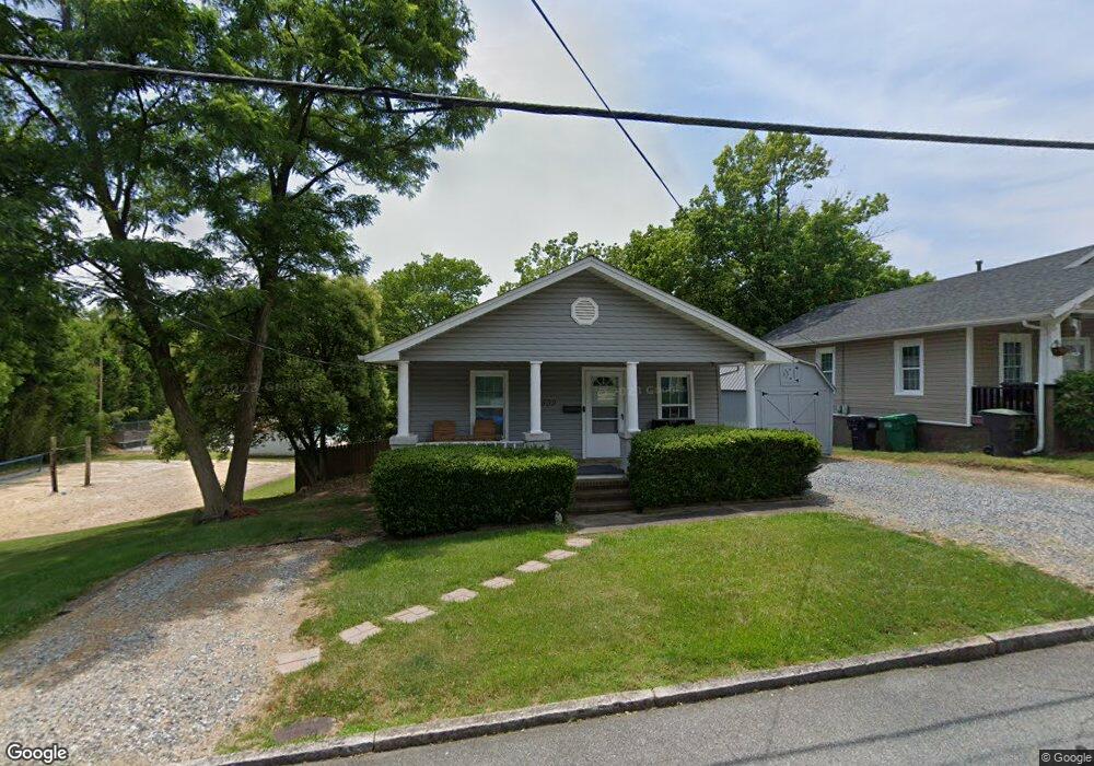
509 W Ray Ave High Point, NC 27262
Downtown High Point NeighborhoodEstimated Value: $102,000 - $229,000
3
Beds
1
Bath
924
Sq Ft
$167/Sq Ft
Est. Value
About This Home
This home is located at 509 W Ray Ave, High Point, NC 27262 and is currently estimated at $154,121, approximately $166 per square foot. 509 W Ray Ave is a home located in Guilford County with nearby schools including Northwood Elementary School, Ferndale Middle School, and High Point Central High School.
Ownership History
Date
Name
Owned For
Owner Type
Purchase Details
Closed on
Jul 18, 2022
Sold by
Zito Investments Llc
Bought by
Zito Nicholas Gerard
Current Estimated Value
Purchase Details
Closed on
Jun 6, 2012
Sold by
Luther Stephen Greg and Luther Cheryl
Bought by
Zito Scott M and Zito Tina I
Home Financials for this Owner
Home Financials are based on the most recent Mortgage that was taken out on this home.
Original Mortgage
$33,800
Interest Rate
3.88%
Mortgage Type
New Conventional
Purchase Details
Closed on
May 1, 1995
Bought by
Luther Stehen Greg
Create a Home Valuation Report for This Property
The Home Valuation Report is an in-depth analysis detailing your home's value as well as a comparison with similar homes in the area
Home Values in the Area
Average Home Value in this Area
Purchase History
| Date | Buyer | Sale Price | Title Company |
|---|---|---|---|
| Zito Nicholas Gerard | $50,000 | Koonce Elizabeth M | |
| Zito Nicholas Gerard | $50,000 | None Listed On Document | |
| Zito Investments Llc | -- | Koonce Elizabeth M | |
| Zito Investments Llc | -- | None Listed On Document | |
| Zito Scott M | $42,500 | None Available | |
| Luther Stehen Greg | $59,800 | -- |
Source: Public Records
Mortgage History
| Date | Status | Borrower | Loan Amount |
|---|---|---|---|
| Previous Owner | Zito Scott M | $33,800 |
Source: Public Records
Tax History Compared to Growth
Tax History
| Year | Tax Paid | Tax Assessment Tax Assessment Total Assessment is a certain percentage of the fair market value that is determined by local assessors to be the total taxable value of land and additions on the property. | Land | Improvement |
|---|---|---|---|---|
| 2025 | $1,084 | $78,700 | $30,000 | $48,700 |
| 2024 | $1,084 | $78,700 | $30,000 | $48,700 |
| 2023 | $1,084 | $78,700 | $30,000 | $48,700 |
| 2022 | $1,061 | $78,700 | $30,000 | $48,700 |
| 2021 | $879 | $63,800 | $25,000 | $38,800 |
| 2020 | $879 | $63,800 | $25,000 | $38,800 |
| 2019 | $879 | $63,800 | $0 | $0 |
| 2018 | $875 | $63,800 | $0 | $0 |
| 2017 | $875 | $63,800 | $0 | $0 |
| 2016 | $941 | $67,100 | $0 | $0 |
| 2015 | $946 | $67,100 | $0 | $0 |
| 2014 | $962 | $67,100 | $0 | $0 |
Source: Public Records
Map
Nearby Homes
- 801 Carrick St
- 702 Gatewood Ave
- 810 Ferndale Blvd
- 1007 N Rotary Dr
- 1013 Johnson St
- 510 Otteray Ave
- 1219 N Main St Unit D
- 300 Edgedale Dr
- 207 Hillcrest Dr
- 1011 Ferndale Blvd
- 509 Chestnut Dr
- 317 Louise Ave
- 1010 Adams St
- 427 Woodbrook Dr
- 326 Louise Ave
- 1116 Ferndale Blvd
- 1042 Rockford Rd
- 416 W Lexington Ave
- 311 Rockspring Rd
- 313 Rockspring Rd