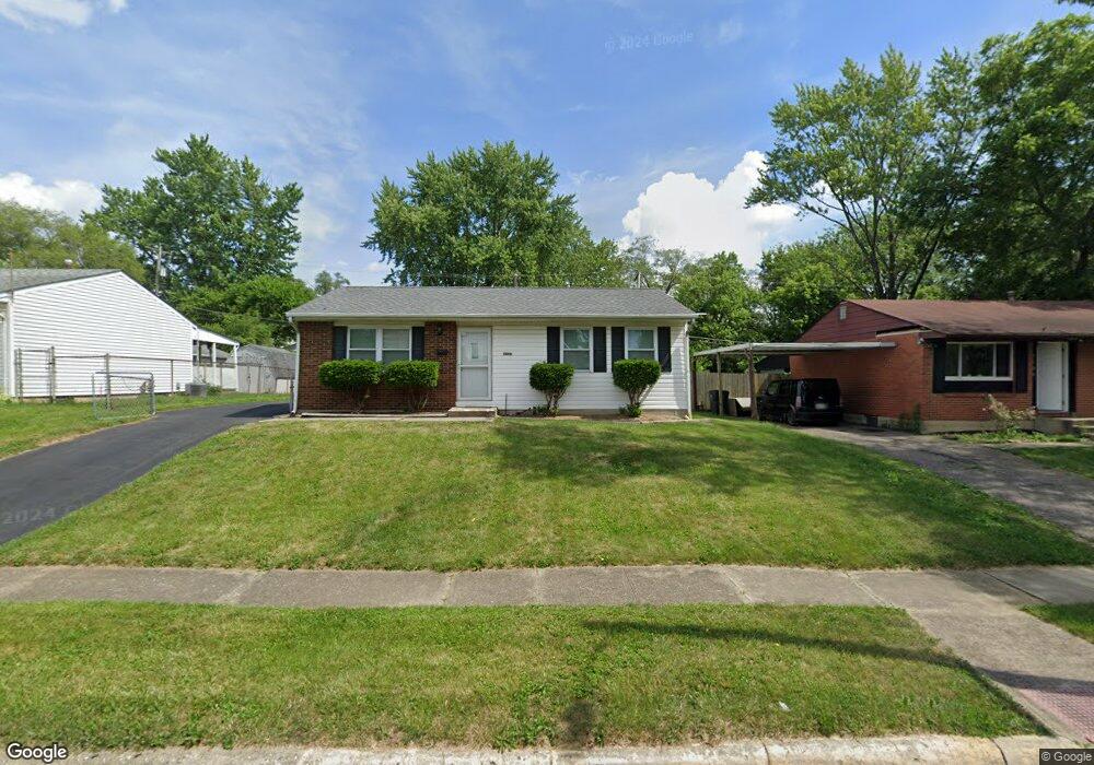
5096 Benham Dr Columbus, OH 43232
East Columbus-White Ash NeighborhoodEstimated Value: $172,773 - $203,000
2
Beds
1
Bath
936
Sq Ft
$201/Sq Ft
Est. Value
About This Home
This home is located at 5096 Benham Dr, Columbus, OH 43232 and is currently estimated at $187,943, approximately $200 per square foot. 5096 Benham Dr is a home located in Franklin County with nearby schools including Groveport Madison High School, Eastland Preparatory Academy, and A+ Arts Academy.
Ownership History
Date
Name
Owned For
Owner Type
Purchase Details
Closed on
Sep 16, 2013
Sold by
Gregory Duane W
Bought by
Gregory Barbara L
Current Estimated Value
Purchase Details
Closed on
Aug 28, 2013
Sold by
Gregory Jared E
Bought by
Gregory Barbara L
Purchase Details
Closed on
Aug 15, 2013
Sold by
Monst Paula A Gregory
Bought by
Gregory Barbara L
Purchase Details
Closed on
Apr 28, 1992
Bought by
Gregory George W
Purchase Details
Closed on
Jul 1, 1980
Create a Home Valuation Report for This Property
The Home Valuation Report is an in-depth analysis detailing your home's value as well as a comparison with similar homes in the area
Home Values in the Area
Average Home Value in this Area
Purchase History
| Date | Buyer | Sale Price | Title Company |
|---|---|---|---|
| Gregory Barbara L | -- | None Available | |
| Gregory Barbara L | -- | None Available | |
| Gregory Barbara L | -- | None Available | |
| Gregory George W | -- | -- | |
| -- | $30,500 | -- |
Source: Public Records
Tax History
| Year | Tax Paid | Tax Assessment Tax Assessment Total Assessment is a certain percentage of the fair market value that is determined by local assessors to be the total taxable value of land and additions on the property. | Land | Improvement |
|---|---|---|---|---|
| 2025 | $2,443 | $50,440 | $16,280 | $34,160 |
| 2024 | $2,443 | $50,440 | $16,280 | $34,160 |
| 2023 | $2,427 | $50,435 | $16,275 | $34,160 |
| 2022 | $2,488 | $26,640 | $6,060 | $20,580 |
| 2021 | $1,660 | $26,640 | $6,060 | $20,580 |
| 2020 | $1,663 | $26,640 | $6,060 | $20,580 |
| 2019 | $1,667 | $23,490 | $5,250 | $18,240 |
| 2018 | $1,681 | $23,490 | $5,250 | $18,240 |
| 2017 | $1,675 | $23,490 | $5,250 | $18,240 |
| 2016 | $1,737 | $20,830 | $3,920 | $16,910 |
| 2015 | $1,686 | $20,830 | $3,920 | $16,910 |
| 2014 | $1,546 | $20,830 | $3,920 | $16,910 |
| 2013 | $733 | $23,135 | $4,340 | $18,795 |
Source: Public Records
Map
Nearby Homes
- 3275 Faycrest Rd
- 5143 Rutledge Dr N
- 4878 Amber Crossing Dr
- 3333 Latonia Ct
- 3246 Latonia Rd
- 5323 Sundale Place S
- 2932 Renfro Rd
- 3455 Tremaine Rd
- 5422 Everson Rd N
- 2908 Renfro Rd
- 3492 Rodell Rd
- 4942 Talbert Dr
- 3493 Tremaine Rd
- 3302 Everson Rd E
- 5361 Parkline Dr
- 4925 Wymore Dr
- 2998 Osgood Rd E
- 5290 Quincy Dr
- 4995 Talford Ct
- 5106 Harbor Blvd
- 5088 Benham Dr
- 5104 Benham Dr
- 5112 Benham Dr
- 5080 Benham Dr
- 5079 Hatfield Dr
- 5071 Hatfield Dr
- 5087 Hatfield Dr
- 3195 Faycrest Rd
- 5063 Hatfield Dr
- 5122 Benham Dr
- 5072 Benham Dr
- 5083 Benham Dr
- 5101 Hatfield Dr
- 3194 Faycrest Rd
- 3190 Benham Ct
- 5057 Hatfield Dr
- 5130 Benham Dr
- 5064 Benham Dr
- 5111 Hatfield Dr
- 5123 Benham Dr
Your Personal Tour Guide
Ask me questions while you tour the home.