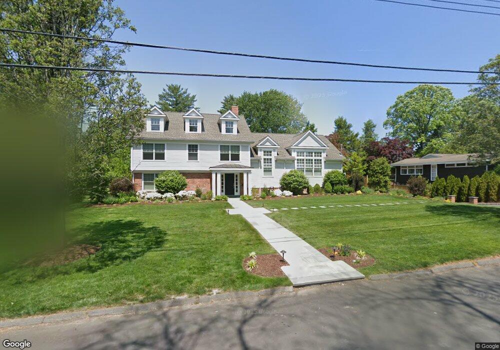
51 Country Ridge Dr Rye Brook, NY 10573
Purchase NeighborhoodEstimated Value: $1,751,000 - $2,435,000
4
Beds
4
Baths
4,032
Sq Ft
$516/Sq Ft
Est. Value
About This Home
This home is located at 51 Country Ridge Dr, Rye Brook, NY 10573 and is currently estimated at $2,082,505, approximately $516 per square foot. 51 Country Ridge Dr is a home located in Westchester County with nearby schools including Bruno M. Ponterio Ridge Street School, Blind Brook Rye Middle School, and Blind Brook High School.
Ownership History
Date
Name
Owned For
Owner Type
Purchase Details
Closed on
Jan 13, 2017
Sold by
Orlando Dianne T
Bought by
Wolf Sara and Wolf Andrew
Current Estimated Value
Purchase Details
Closed on
May 22, 2013
Sold by
Tiso Elizabeth V
Bought by
Tiso Elizabeth and The Elizabeth V Tiso Revocable Trust
Purchase Details
Closed on
Apr 22, 2004
Sold by
Tiso Elizabeth V
Bought by
Tiso Elizabeth
Create a Home Valuation Report for This Property
The Home Valuation Report is an in-depth analysis detailing your home's value as well as a comparison with similar homes in the area
Home Values in the Area
Average Home Value in this Area
Purchase History
| Date | Buyer | Sale Price | Title Company |
|---|---|---|---|
| Wolf Sara | $1,667,500 | Benchmark Title | |
| Tiso Elizabeth | -- | None Available | |
| Tiso Elizabeth | -- | Fidelity National Title Ins |
Source: Public Records
Tax History Compared to Growth
Tax History
| Year | Tax Paid | Tax Assessment Tax Assessment Total Assessment is a certain percentage of the fair market value that is determined by local assessors to be the total taxable value of land and additions on the property. | Land | Improvement |
|---|---|---|---|---|
| 2024 | $54,399 | $1,971,500 | $595,700 | $1,375,800 |
| 2023 | $48,937 | $1,895,700 | $567,400 | $1,328,300 |
| 2022 | $48,439 | $1,788,400 | $567,400 | $1,221,000 |
| 2021 | $47,924 | $1,655,900 | $567,400 | $1,088,500 |
| 2020 | $44,081 | $1,655,900 | $567,400 | $1,088,500 |
| 2019 | $82,183 | $1,723,100 | $453,700 | $1,269,400 |
| 2018 | $29,371 | $1,673,600 | $426,900 | $1,246,700 |
| 2017 | $3,693 | $1,575,100 | $434,100 | $1,141,000 |
| 2016 | $31,514 | $872,200 | $427,200 | $445,000 |
| 2015 | -- | $1,017,800 | $421,700 | $596,100 |
| 2014 | -- | $867,400 | $362,400 | $505,000 |
| 2013 | -- | $842,400 | $337,400 | $505,000 |
Source: Public Records
Map
Nearby Homes
- 53 Country Ridge Dr
- 53 Shady Ln
- 15 Walker Ct
- 26 Shady Ln
- 15 Rockinghorse Trail
- 7 Curt Terrace
- 27 Doral Greens Dr E
- 70 Glenville St
- 15 Arrowwood Cir Unit 136
- 125 Bowman Dr
- 301 River W
- 12 Glenville St Unit 108
- 351 Pemberwick Rd Unit 111
- 1 Primrose Ln
- 5 Bristol Ln
- 27 Lavender Ln
- Cypress Plan at Kingfield - Townhouse Suites
- Dogwood Plan at Kingfield - Single-Family Suites
- Aspen Plan at Kingfield - Townhouse Suites
- Birch Plan at Kingfield - Single-Family Suites
- 49 Country Ridge Dr
- 36 Country Ridge Dr
- 47 Country Ridge Dr
- 32 Country Ridge Dr
- 55 Country Ridge Dr
- 40 Country Ridge Dr
- 28 Country Ridge Dr
- 44 Country Ridge Dr
- 45 Country Ridge Dr
- 24 Country Ridge Dr
- 57 Country Ridge Dr
- 14 Holly Ln
- 12 Holly Ln
- 10 Holly Ln
- 48 Country Ridge Dr
- 43 Country Ridge Dr N
- 22 Country Ridge Dr
- 18 Holly Ln
- 8 Holly Ln
- 59 Country Ridge Dr