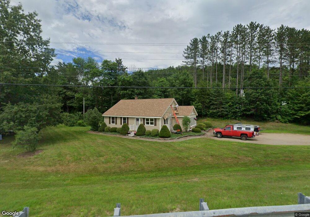
51 Cross Rd Thornton, NH 03285
Estimated Value: $414,000 - $521,000
3
Beds
2
Baths
1,724
Sq Ft
$269/Sq Ft
Est. Value
About This Home
This home is located at 51 Cross Rd, Thornton, NH 03285 and is currently estimated at $464,383, approximately $269 per square foot. 51 Cross Rd is a home located in Grafton County with nearby schools including Thornton Central School and Plymouth Regional High School.
Ownership History
Date
Name
Owned For
Owner Type
Purchase Details
Closed on
Jan 25, 2024
Sold by
Duffy Ernest J and Duffy Deborah
Bought by
Duffy Ft and Duffy
Current Estimated Value
Purchase Details
Closed on
Jan 30, 2015
Sold by
Duffy Ernest J
Bought by
Patterson Morris N and Patterson Barbara D
Create a Home Valuation Report for This Property
The Home Valuation Report is an in-depth analysis detailing your home's value as well as a comparison with similar homes in the area
Home Values in the Area
Average Home Value in this Area
Purchase History
| Date | Buyer | Sale Price | Title Company |
|---|---|---|---|
| Duffy Ft | -- | None Available | |
| Duffy Ft | -- | None Available | |
| Patterson Morris N | $163,866 | -- |
Source: Public Records
Tax History Compared to Growth
Tax History
| Year | Tax Paid | Tax Assessment Tax Assessment Total Assessment is a certain percentage of the fair market value that is determined by local assessors to be the total taxable value of land and additions on the property. | Land | Improvement |
|---|---|---|---|---|
| 2024 | $4,423 | $389,000 | $128,400 | $260,600 |
| 2023 | $4,476 | $215,600 | $70,800 | $144,800 |
| 2022 | $4,224 | $211,100 | $70,800 | $140,300 |
| 2021 | $4,385 | $211,100 | $70,800 | $140,300 |
| 2020 | $4,245 | $211,100 | $70,800 | $140,300 |
| 2019 | $3,943 | $211,100 | $70,800 | $140,300 |
| 2018 | $3,310 | $168,800 | $50,400 | $118,400 |
| 2017 | $3,300 | $168,800 | $50,400 | $118,400 |
| 2016 | $2,794 | $168,800 | $50,400 | $118,400 |
| 2015 | $3,224 | $168,800 | $50,400 | $118,400 |
| 2014 | $3,172 | $168,800 | $50,400 | $118,400 |
| 2013 | $3,393 | $185,000 | $43,000 | $142,000 |
Source: Public Records
Map
Nearby Homes
- 30 Tuxette Rd
- 0 Avery- McGee Rd Unit 6
- 151 Millbrook Rd
- 3447 US Route 3
- 3481 Us Route 3
- 6 Melinas Way
- 3 Melinas Way
- 43 Melina's Way
- 13 Champions Way
- 93 Waterthorn Rd
- Lot 2 Covered Bridge Rd
- 53 Sunrise Hill Rd
- 53 Diamond Ledge Rd
- 15 Tennis Ln Unit B14
- 189 Covered Bridge Rd
- 26 Jack's Run
- 20 Jack O'Lantern Dr Unit 27
- 65 Mountain River East Rd Unit 58
- Lot 14 Centennial Way
- 2832 Nh Route 175
- 29 Church St
- 33 Church St
- 15 Church St
- 10 Cricket Hollow Path
- 72 Cross Rd
- 30 Cricket Hollow Path
- 3279 N Us Rte 3 Hwy
- 24 Robbins Nest Rd
- 99 Cross Rd
- 3187 Us Route 3 Unit 3189
- 3187 Us Route 3
- 3187 3189 Us Route 3 Daniel Webster Hwy
- 19 Robbins Nest Rd
- 104 Cross Rd
- 00 Cross Rd
- 107 Cross Rd
- 22 Herbert St
- 3244 Us Route 3
- 3243 Us Route 3
- 22 Merrill Access Rd