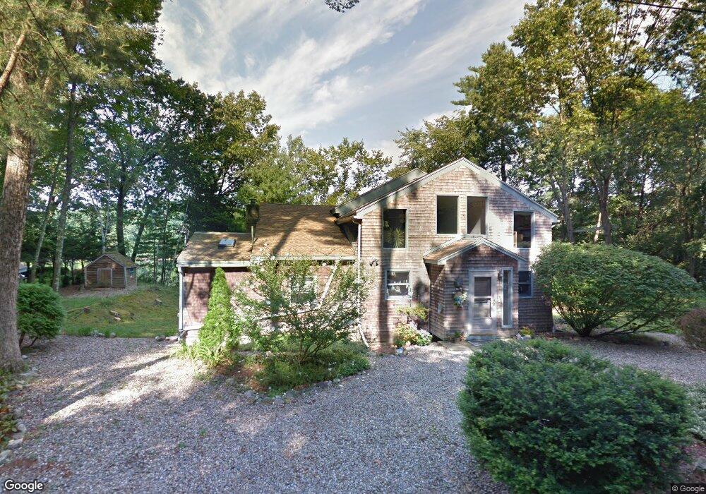
51 Riverbend Rd Tyngsboro, MA 01879
Estimated Value: $412,000 - $627,000
1
Bed
2
Baths
1,898
Sq Ft
$281/Sq Ft
Est. Value
About This Home
This home is located at 51 Riverbend Rd, Tyngsboro, MA 01879 and is currently estimated at $534,078, approximately $281 per square foot. 51 Riverbend Rd is a home located in Middlesex County with nearby schools including Tyngsborough Elementary School, Tyngsborough Middle School, and Tyngsborough High School.
Ownership History
Date
Name
Owned For
Owner Type
Purchase Details
Closed on
Nov 8, 2021
Sold by
Pendergast Patrick F and Pendergast Patricia
Bought by
Pendergast Ft and Bouchard
Current Estimated Value
Purchase Details
Closed on
Apr 22, 2004
Sold by
Pendergast Patrick F
Bought by
Pendergast Patrick F and Bouchard Patricia H
Purchase Details
Closed on
May 24, 1971
Bought by
Pendergast Patrick F and Bouchard Patricia H
Create a Home Valuation Report for This Property
The Home Valuation Report is an in-depth analysis detailing your home's value as well as a comparison with similar homes in the area
Home Values in the Area
Average Home Value in this Area
Purchase History
| Date | Buyer | Sale Price | Title Company |
|---|---|---|---|
| Pendergast Ft | -- | None Available | |
| Pendergast Patrick F | -- | -- | |
| Pendergast Patrick F | $12,000 | -- |
Source: Public Records
Mortgage History
| Date | Status | Borrower | Loan Amount |
|---|---|---|---|
| Previous Owner | Pendergast Patrick F | $25,000 | |
| Previous Owner | Pendergast Patrick F | $50,000 |
Source: Public Records
Tax History Compared to Growth
Tax History
| Year | Tax Paid | Tax Assessment Tax Assessment Total Assessment is a certain percentage of the fair market value that is determined by local assessors to be the total taxable value of land and additions on the property. | Land | Improvement |
|---|---|---|---|---|
| 2025 | $58 | $468,700 | $186,000 | $282,700 |
| 2024 | $5,533 | $435,000 | $180,700 | $254,300 |
| 2023 | $5,373 | $380,000 | $150,900 | $229,100 |
| 2022 | $5,244 | $351,000 | $138,600 | $212,400 |
| 2021 | $5,176 | $322,100 | $126,300 | $195,800 |
| 2020 | $5,029 | $309,500 | $115,800 | $193,700 |
| 2019 | $4,820 | $284,700 | $110,500 | $174,200 |
| 2018 | $4,816 | $281,500 | $110,500 | $171,000 |
| 2017 | $4,551 | $265,200 | $110,500 | $154,700 |
| 2016 | $4,334 | $246,800 | $103,500 | $143,300 |
| 2015 | $4,186 | $246,800 | $103,500 | $143,300 |
Source: Public Records
Map
Nearby Homes
- 56 Frost Rd
- 75 Frost Rd
- 1 Patricia Dr
- 46 Pawtucket Blvd Unit 38
- 46 Pawtucket Blvd Unit 37
- 52 Pawtucket Blvd Unit 21
- 30 Tamarack Way Unit 30
- 26 Juniper Ln Unit 64
- 33 Phalanx St
- 22 Juniper Ln Unit 66
- 28 Juniper Ln Unit 65
- 11 Juniper Ln Unit 14
- 32 Juniper Ln Unit 61
- 43 Juniper Ln Unit 30
- 20 Juniper Ln Unit 67
- 17 Juniper Ln Unit 17
- 15 Norris Rd
- 24 Old Tyng Rd
- 17 Norris Rd
- 1 Wintergreen Dr