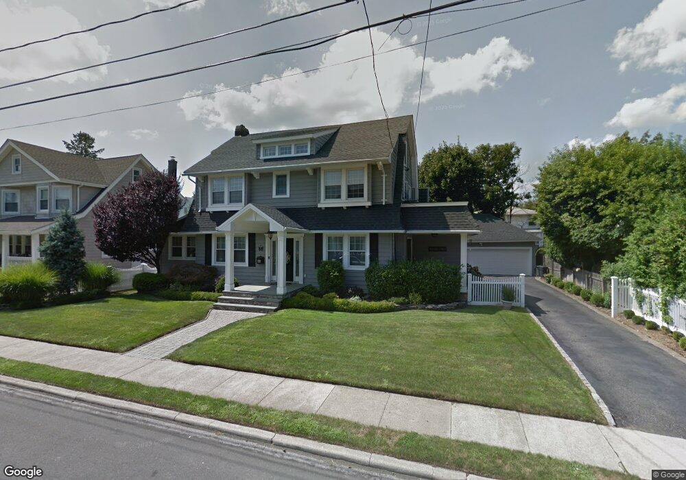
51 Watts Place Lynbrook, NY 11563
Estimated Value: $831,000 - $976,761
3
Beds
3
Baths
2,580
Sq Ft
$350/Sq Ft
Est. Value
About This Home
This home is located at 51 Watts Place, Lynbrook, NY 11563 and is currently estimated at $903,881, approximately $350 per square foot. 51 Watts Place is a home located in Nassau County with nearby schools including Lynbrook Senior High School and Our Lady Of Peace School.
Ownership History
Date
Name
Owned For
Owner Type
Purchase Details
Closed on
May 10, 2018
Sold by
Lynch Bernard D and Lynch Dawn M
Bought by
Coco Ryan and Coco Keely
Current Estimated Value
Home Financials for this Owner
Home Financials are based on the most recent Mortgage that was taken out on this home.
Original Mortgage
$665,212
Outstanding Balance
$572,770
Interest Rate
4.4%
Mortgage Type
New Conventional
Estimated Equity
$331,111
Purchase Details
Closed on
Jun 18, 1999
Sold by
Pittoni Grace
Bought by
Lynch Bernard D and Lynch Dawn M
Create a Home Valuation Report for This Property
The Home Valuation Report is an in-depth analysis detailing your home's value as well as a comparison with similar homes in the area
Home Values in the Area
Average Home Value in this Area
Purchase History
| Date | Buyer | Sale Price | Title Company |
|---|---|---|---|
| Coco Ryan | $730,000 | First American Title | |
| Lynch Bernard D | $250,000 | -- | |
| -- | -- | -- |
Source: Public Records
Mortgage History
| Date | Status | Borrower | Loan Amount |
|---|---|---|---|
| Open | Coco Ryan | $665,212 |
Source: Public Records
Tax History Compared to Growth
Tax History
| Year | Tax Paid | Tax Assessment Tax Assessment Total Assessment is a certain percentage of the fair market value that is determined by local assessors to be the total taxable value of land and additions on the property. | Land | Improvement |
|---|---|---|---|---|
| 2025 | $14,502 | $686 | $253 | $433 |
| 2024 | $1,071 | $648 | $238 | $410 |
| 2023 | $13,784 | $730 | $277 | $453 |
| 2022 | $13,784 | $689 | $253 | $436 |
| 2021 | $17,398 | $735 | $270 | $465 |
| 2020 | $12,741 | $855 | $500 | $355 |
| 2019 | $1,436 | $916 | $502 | $414 |
| 2018 | $1,500 | $978 | $0 | $0 |
| 2017 | $10,208 | $1,039 | $410 | $629 |
| 2016 | $11,710 | $1,357 | $536 | $821 |
| 2015 | $2,015 | $1,357 | $536 | $821 |
| 2014 | $2,015 | $1,357 | $536 | $821 |
| 2013 | $1,849 | $1,357 | $536 | $821 |
Source: Public Records
Map
Nearby Homes
- 161 Union Ave Unit 9
- 85 Oakland Ave
- 183 Atlantic Ave Unit 2
- 183 Atlantic Ave Unit 8
- 185 Atlantic Ave Unit C-1
- 185 Atlantic Ave Unit C-3
- 73 Peterson Place
- 200 Atlantic Ave Unit 223
- 200 Atlantic Ave Unit 212
- 200 Atlantic Ave Unit 321
- 10 Cornell Place
- 21 Carter Ct
- 99 Durland Rd
- 63 Lenox Ave
- 725 Scranton Ave
- 114 Atlantic Ave Unit 89
- 230 Broadway
- 315 Atlantic Ave
- 315 Atlantic Ave Unit 1A
- 280 Atlantic Ave Unit 140