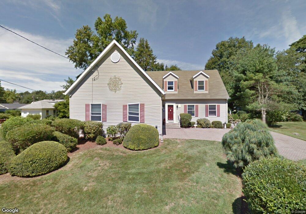
51 Whitecap Rd Niantic, CT 06357
Estimated Value: $718,000 - $927,000
3
Beds
3
Baths
2,153
Sq Ft
$382/Sq Ft
Est. Value
About This Home
This home is located at 51 Whitecap Rd, Niantic, CT 06357 and is currently estimated at $823,000, approximately $382 per square foot. 51 Whitecap Rd is a home located in New London County with nearby schools including East Lyme Middle School, East Lyme High School, and The Light House Voc-Ed Center.
Ownership History
Date
Name
Owned For
Owner Type
Purchase Details
Closed on
Apr 8, 2011
Sold by
Hayes Thomas F and Hayes Joan S
Bought by
Hayes Thomas F and Hayes Joan S
Current Estimated Value
Purchase Details
Closed on
Mar 1, 1996
Sold by
Lagrotteria James V and Lagrotteria Jane C
Bought by
Hayes Thomas F and Hayes Joan S
Create a Home Valuation Report for This Property
The Home Valuation Report is an in-depth analysis detailing your home's value as well as a comparison with similar homes in the area
Home Values in the Area
Average Home Value in this Area
Purchase History
| Date | Buyer | Sale Price | Title Company |
|---|---|---|---|
| Hayes Thomas F | -- | -- | |
| Hayes Thomas F | $50,000 | -- | |
| Hayes Thomas F | -- | -- | |
| Hayes Thomas F | $50,000 | -- |
Source: Public Records
Mortgage History
| Date | Status | Borrower | Loan Amount |
|---|---|---|---|
| Open | Hayes Thomas F | $111,000 | |
| Previous Owner | Hayes Thomas F | $160,000 | |
| Previous Owner | Hayes Thomas F | $114,433 |
Source: Public Records
Tax History
| Year | Tax Paid | Tax Assessment Tax Assessment Total Assessment is a certain percentage of the fair market value that is determined by local assessors to be the total taxable value of land and additions on the property. | Land | Improvement |
|---|---|---|---|---|
| 2025 | $8,204 | $292,880 | $112,630 | $180,250 |
| 2024 | $7,717 | $292,880 | $112,630 | $180,250 |
| 2023 | $7,287 | $292,880 | $112,630 | $180,250 |
| 2022 | $6,982 | $292,880 | $112,630 | $180,250 |
| 2021 | $6,402 | $224,560 | $97,580 | $126,980 |
| 2020 | $6,369 | $224,560 | $97,580 | $126,980 |
| 2019 | $6,330 | $224,560 | $97,580 | $126,980 |
| 2018 | $6,142 | $224,560 | $97,580 | $126,980 |
| 2017 | $5,874 | $224,560 | $97,580 | $126,980 |
| 2016 | $5,853 | $230,790 | $97,580 | $133,210 |
| 2015 | $5,703 | $230,790 | $97,580 | $133,210 |
| 2014 | $5,546 | $230,790 | $97,580 | $133,210 |
Source: Public Records
Map
Nearby Homes
- 61 Whitecap Rd
- 36 Attawan Rd
- 26 Mohawk Dr
- 15 Griswold Rd
- 127 Black Point Rd Unit 7
- 42 S Washington Ave
- 19 Sapia Dr
- 12 Spinnaker Dr
- 31 Regatta Dr
- 18 Compass Ct
- 468 Main St Unit 318
- 468 Main St Unit 111
- 43 Village Crossing Unit 43
- 47 Village Crossing Unit 47
- 46 Village Crossing Unit 46
- 97 W Main St Unit 36
- 55 Corey Ln
- 43 Roxbury Ct
- 185 Main St Unit 301
- 185 Main St Unit 305
- 53 Whitecap Rd
- 47 Whitecap Rd
- 50 Indianola Rd
- 52 Indianola Rd
- 48 Whitecap Rd
- 48 Whitecap Rd
- 48 Indianola Rd
- 46 Whitecap Rd
- 52 Whitecap Rd
- 56 Indianola Rd
- 43 Whitecap Rd
- 44 Whitecap Rd
- 46 Indianola Rd
- 58 Indianola Rd
- 57 Whitecap Rd
- 56 Whitecap Rd
- 47 Sea Breeze Ave
- 53 Indianola Rd
- 49 Indianola Rd
- 49 Sea Breeze Ave
Your Personal Tour Guide
Ask me questions while you tour the home.