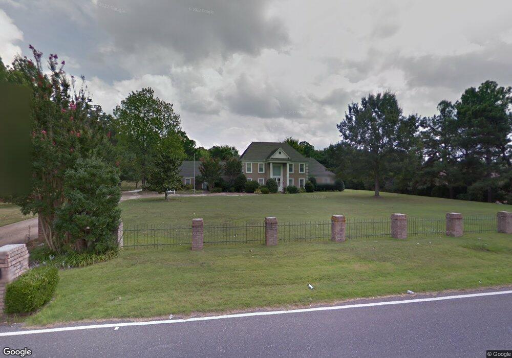
510 N Walnut Bend Rd Cordova, TN 38018
Cordova NeighborhoodEstimated Value: $124,000 - $1,403,000
5
Beds
6
Baths
4,672
Sq Ft
$165/Sq Ft
Est. Value
About This Home
This home is located at 510 N Walnut Bend Rd, Cordova, TN 38018 and is currently estimated at $769,333, approximately $164 per square foot. 510 N Walnut Bend Rd is a home located in Shelby County with nearby schools including Cordova Elementary School, Cordova Middle School, and Cordova High School.
Ownership History
Date
Name
Owned For
Owner Type
Purchase Details
Closed on
Jul 29, 2011
Sold by
Pearce James R
Bought by
Pearce Cheryl L
Current Estimated Value
Purchase Details
Closed on
Oct 12, 1998
Sold by
Daniel Storey
Bought by
Pearce James R and Pearce Cheryl L
Home Financials for this Owner
Home Financials are based on the most recent Mortgage that was taken out on this home.
Original Mortgage
$425,000
Interest Rate
6.8%
Mortgage Type
Balloon
Create a Home Valuation Report for This Property
The Home Valuation Report is an in-depth analysis detailing your home's value as well as a comparison with similar homes in the area
Home Values in the Area
Average Home Value in this Area
Purchase History
| Date | Buyer | Sale Price | Title Company |
|---|---|---|---|
| Pearce Cheryl L | -- | Erickson Title & Closing Llc | |
| Pearce James R | $390,000 | -- | |
| Pearce James R | $390,000 | -- |
Source: Public Records
Mortgage History
| Date | Status | Borrower | Loan Amount |
|---|---|---|---|
| Closed | Pearce James R | $425,000 |
Source: Public Records
Tax History Compared to Growth
Tax History
| Year | Tax Paid | Tax Assessment Tax Assessment Total Assessment is a certain percentage of the fair market value that is determined by local assessors to be the total taxable value of land and additions on the property. | Land | Improvement |
|---|---|---|---|---|
| 2025 | -- | $151,150 | $31,500 | $119,650 |
| 2024 | $4,129 | $121,800 | $27,400 | $94,400 |
| 2023 | $7,420 | $121,800 | $27,400 | $94,400 |
| 2022 | $7,420 | $121,800 | $27,400 | $94,400 |
| 2021 | $7,507 | $121,800 | $27,400 | $94,400 |
| 2020 | $7,090 | $97,850 | $27,400 | $70,450 |
| 2019 | $7,090 | $97,850 | $27,400 | $70,450 |
| 2018 | $7,090 | $97,850 | $27,400 | $70,450 |
| 2017 | $4,022 | $97,850 | $27,400 | $70,450 |
| 2016 | $3,984 | $91,175 | $0 | $0 |
| 2014 | $3,984 | $91,175 | $0 | $0 |
Source: Public Records
Map
Nearby Homes
- 470 Walnut Point Cove
- 548 Wesley Woods Dr
- 334 Brook Ridge Dr
- 538 Bedlington Dr
- 537 Cairn Drive Extension
- 441 Griffon Dr
- 747 Overcup Oaks Cove
- 8532 Shingle Oaks Dr
- 432 Bruins Trace
- 263 Shadow Grove Cove
- 8170 Wood Moss Cove
- 731 Walnut Woods Cove N
- 8301 Weatherwood Ln
- 00 Walnut Grove Rd
- 8570 May Orchard Ln
- 370 Lida Ln
- 8663 Colleton Way
- 8667 Colleton Way
- 8671 Colleton Way
- 0 Chelsea Meadow Lot 40 Cove Unit 10005859
- 488 N Walnut Bend Rd
- 536 N Walnut Bend Rd
- 8309 Cedar Trail Cove
- 473 Walnut Point Cove
- 474 N Walnut Bend Rd
- 8310 Cedar Trail Cove
- 483 N Walnut Bend Rd
- 459 Walnut Point Cove
- 8327 Walnut Trail Cove
- 8293 Cedar Trail Cove
- 450 N Walnut Bend Rd
- 482 Brook Ridge Cir
- 474 Brook Ridge Cir
- 570 N Walnut Bend Rd
- 8294 Cedar Trail Cove
- 457 N Walnut Bend Rd
- 486 Brook Ridge Cir
- 457 N Walnut Bend Rd
- 456 Walnut Point Cove
- 434 N Walnut Bend Rd