


510 Ransom St Blowing Rock, NC 28605
Estimated payment $5,169/month
Highlights
- Popular Property
- Guest House
- Vaulted Ceiling
- Blowing Rock Elementary School Rated A
- Second Kitchen
- Traditional Architecture
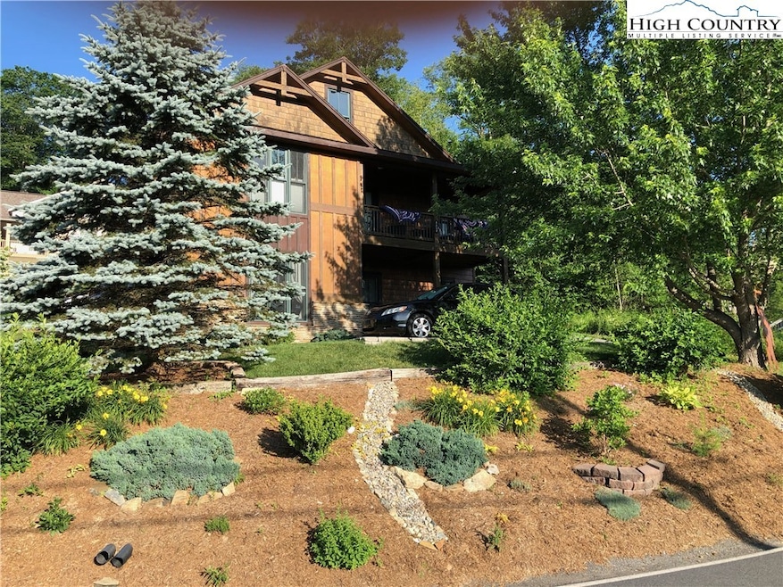
About This Home
Perfectly positioned Blowing Rock retreat that’s less than half a mile walk to the heart of Main Street, this versatile mountain home offers the rare combination of location, income potential, and mountain charm. Park the car and enjoy strolling to restaurants, shopping, parks, and seasonal festivities with ease.
The main level also features a bright, open floor plan filled with natural light, vaulted ceilings, and access to multiple porches., giving you the perfect setting to enjoy the year round opportunities for outdoor living. Main upper level features a spacious primary bedroom with vaulted ceiling and ensuite bathroom. There is also a guest bedroom and another full bath on the main level. The open kitchen features a large granite topped island and stainless steel appliances, ideal for both full-time living and entertaining. A gas corner fireplace adds warmth and ambiance to the main living area for cozy mountain evenings. The fully finished lower level can function as a private apartment, complete with its own bedroom, full bath, living/entertaining space, exterior access, and parking for two cars—making it ideal for a long-term rental, guest suite, in-law quarters, or dual living arrangements. The home has a documented rental history, with both levels generating strong income. A large storage room also provides some future options for the lower level.
City water and sewer, central air, high-speed internet, and the option for long-term rentals add to the property’s flexibility and value. The private paved driveway offers easy year round access, with city-maintained roads leading right to the home.
Whether you’re seeking a primary mountain residence, a second home close to town, or a smart investment property with built-in income, this home delivers exceptional opportunity in one of Blowing Rock’s most walkable locations.
Listing Agent
Appalachian Properties Brokerage Phone: (828) 719-6220 Listed on: 12/04/2025
Home Details
Home Type
- Single Family
Est. Annual Taxes
- $3,610
Year Built
- Built in 2008
HOA Fees
- $17 Monthly HOA Fees
Home Design
- Traditional Architecture
- Cottage
- Wood Frame Construction
- Shingle Roof
- Asphalt Roof
- Wood Siding
- Shake Siding
Interior Spaces
- 1-Story Property
- Living Quarters
- Vaulted Ceiling
- Gas Fireplace
- Propane Fireplace
- Double Pane Windows
- Finished Basement
- Laundry in Basement
Kitchen
- Second Kitchen
- Electric Cooktop
- Dishwasher
Bedrooms and Bathrooms
- 3 Bedrooms
- 3 Full Bathrooms
Laundry
- Laundry on main level
- Dryer
- Washer
Parking
- No Garage
- Private Parking
- Driveway
- Paved Parking
Schools
- Blowing Rock Elementary School
- Watauga High School
Utilities
- Zoned Cooling
- Heat Pump System
- Gas Water Heater
- High Speed Internet
- Cable TV Available
Additional Features
- Open Patio
- 8,276 Sq Ft Lot
- Guest House
Listing and Financial Details
- Tax Lot 5
- Assessor Parcel Number 2817-06-4381-000
Map
Home Values in the Area
Average Home Value in this Area
Tax History
| Year | Tax Paid | Tax Assessment Tax Assessment Total Assessment is a certain percentage of the fair market value that is determined by local assessors to be the total taxable value of land and additions on the property. | Land | Improvement |
|---|---|---|---|---|
| 2025 | $3,713 | $502,800 | $78,100 | $424,700 |
| 2024 | $3,713 | $502,800 | $78,100 | $424,700 |
| 2023 | $3,539 | $502,800 | $78,100 | $424,700 |
| 2022 | $3,539 | $502,800 | $78,100 | $424,700 |
| 2021 | $3,069 | $358,800 | $53,300 | $305,500 |
| 2020 | $2,925 | $358,800 | $53,300 | $305,500 |
| 2019 | $2,925 | $358,800 | $53,300 | $305,500 |
| 2018 | $2,674 | $358,800 | $53,300 | $305,500 |
| 2017 | $2,674 | $358,800 | $53,300 | $305,500 |
| 2013 | -- | $386,800 | $35,500 | $351,300 |
Property History
| Date | Event | Price | List to Sale | Price per Sq Ft |
|---|---|---|---|---|
| 12/04/2025 12/04/25 | For Sale | $925,000 | -- | $458 / Sq Ft |
Purchase History
| Date | Type | Sale Price | Title Company |
|---|---|---|---|
| Warranty Deed | $545,000 | None Available | |
| Interfamily Deed Transfer | -- | None Available | |
| Warranty Deed | -- | None Available |
Mortgage History
| Date | Status | Loan Amount | Loan Type |
|---|---|---|---|
| Open | $517,750 | New Conventional |
Source: High Country Association of REALTORS®
MLS Number: 259266
APN: 2817-06-4381-000
Disclaimer: Certain information contained herein is derived from information provided by parties other than Homes.com. All information provided is deemed reliable, but is not guaranteed to be accurate and should be independently verified.
![]() IDX information is provided exclusively for consumers' personal, non-commercial use, that it may not be used for any purpose other than to identify prospective properties consumers may be interested in purchasing. Data is deemed reliable but is not guaranteed accurate by the MLS.
IDX information is provided exclusively for consumers' personal, non-commercial use, that it may not be used for any purpose other than to identify prospective properties consumers may be interested in purchasing. Data is deemed reliable but is not guaranteed accurate by the MLS.
- 105 Clary Ct Unit 8
- 101 Clary Ct Unit 101
- 148 Royal Oaks Dr Unit 231
- 148 Royal Oaks Dr Unit 226
- 505 Skyland View Dr
- 214 Village Green Unit B2
- 492 Skyland View Dr
- 215 Cone Vista Cir Unit B
- 155 Glen Burney Ln Unit C-8
- 155 Glen Burney Ln Unit C6
- 366 Spruce Rd
- 257 Sunset Dr
- 116 Globe Rd
- 3385 Highway 321
- 1150 Main St Unit Dogwood
- 130 Prudden Ln Unit 103
- 270 Buxton St
- 181 Pheasant Ln
- 1968 Main St Unit 21
- 125 Grassy Knoll Way
- 157 Cliff Ln Unit 1
- 135 Caleb Dr Unit 4
- 5844 Blowing Rock Blvd Unit 19
- 197 Old Us Highway 321
- 1412 Deck Hill Rd
- 251 Rembrandt Dr
- 304 Madison Ave
- 530 Marion Cornett Rd
- 475 Meadowview Dr Unit CollegePlaceCondo
- 128 Zeb St
- 128 Zeb St Unit C101
- 206 Rushing Creek Dr
- 153 Crossing Way
- 222 Birch St Unit 222-A
- 105 Assembly Dr
- 133 Boone Docks St Unit 10
- 204 Furman Rd
- 241 Shadowline Dr
- 610 State Farm Rd Unit 3
- 2348 N Carolina 105 Unit 11
