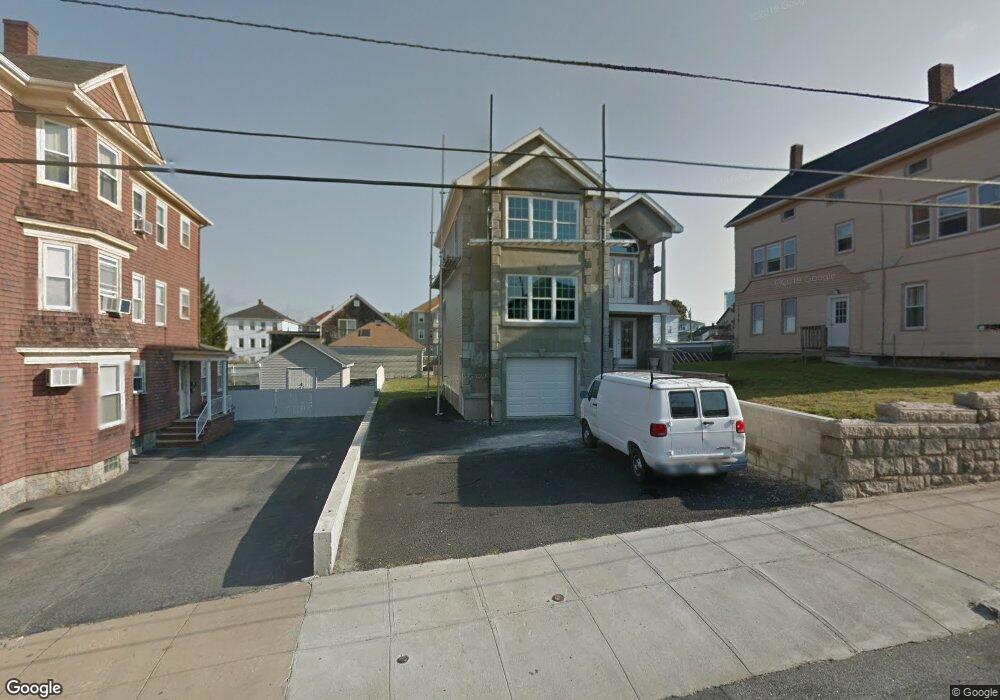
510 State Ave Fall River, MA 02724
Sandy Beach NeighborhoodEstimated Value: $442,104 - $510,000
3
Beds
2
Baths
1,900
Sq Ft
$253/Sq Ft
Est. Value
About This Home
This home is located at 510 State Ave, Fall River, MA 02724 and is currently estimated at $479,776, approximately $252 per square foot. 510 State Ave is a home located in Bristol County with nearby schools including Henry Lord Community School, B M C Durfee High School, and Argosy Collegiate Charter School.
Ownership History
Date
Name
Owned For
Owner Type
Purchase Details
Closed on
Jun 29, 2018
Sold by
Ponte Phil
Bought by
Viveiros Brian L
Current Estimated Value
Home Financials for this Owner
Home Financials are based on the most recent Mortgage that was taken out on this home.
Original Mortgage
$200,000
Outstanding Balance
$172,993
Interest Rate
4.6%
Mortgage Type
New Conventional
Estimated Equity
$306,783
Purchase Details
Closed on
Feb 17, 2009
Sold by
Ponte Joseph C
Bought by
Ponte Phil and Ponte Priscella Lee
Create a Home Valuation Report for This Property
The Home Valuation Report is an in-depth analysis detailing your home's value as well as a comparison with similar homes in the area
Home Values in the Area
Average Home Value in this Area
Purchase History
| Date | Buyer | Sale Price | Title Company |
|---|---|---|---|
| Viveiros Brian L | $340,000 | -- | |
| Ponte Phil | $221,000 | -- | |
| Ponte Phil | $221,000 | -- |
Source: Public Records
Mortgage History
| Date | Status | Borrower | Loan Amount |
|---|---|---|---|
| Open | Viveiros Brian L | $200,000 | |
| Closed | Ponte Phil | $200,000 | |
| Previous Owner | Ponte Phil | $60,000 | |
| Previous Owner | Ponte Phil | $80,000 |
Source: Public Records
Tax History Compared to Growth
Tax History
| Year | Tax Paid | Tax Assessment Tax Assessment Total Assessment is a certain percentage of the fair market value that is determined by local assessors to be the total taxable value of land and additions on the property. | Land | Improvement |
|---|---|---|---|---|
| 2025 | $5,266 | $459,900 | $108,000 | $351,900 |
| 2024 | $4,941 | $430,000 | $104,000 | $326,000 |
| 2023 | $4,897 | $399,100 | $85,900 | $313,200 |
| 2022 | $4,346 | $344,400 | $81,800 | $262,600 |
| 2021 | $4,858 | $303,700 | $77,900 | $225,800 |
| 2020 | $4,164 | $288,200 | $76,700 | $211,500 |
| 2019 | $5,501 | $241,800 | $73,900 | $167,900 |
| 2018 | $4,496 | $238,100 | $80,000 | $158,100 |
| 2017 | $3,244 | $231,700 | $76,300 | $155,400 |
| 2016 | $3,106 | $227,900 | $81,200 | $146,700 |
| 2015 | $3,012 | $230,300 | $81,200 | $149,100 |
| 2014 | $2,849 | $226,500 | $78,800 | $147,700 |
Source: Public Records
Map
Nearby Homes
- 579 Summit St Unit 3
- 579 Summit St Unit 2
- 391 Clarkson St
- 0 Sampson St
- 584-586 Mount Hope Ave
- 238 Judson St
- 66 Bailey St
- 126 Wheeler St
- 39 Hilton St
- 616 Woodman St
- 495 Hooper St
- 133 Kempton St
- 17 Lynwood St
- 105 Borden Rd
- 8 Bronson St
- 59 Mount Hope Ave
- 12 Bronson St
- 16 Bronson St
- 20 Bronson St
- 0 Kaufman Rd Unit 73333701
- 520 State Ave
- 0 Audet St Unit 835541
- 0 Audet St Unit 835544
- 0 Audet St Unit 934551
- 243 State Ave
- 526 State Ave
- 237 State Ave
- 472 State Ave
- 137 Last St
- 251 State Ave
- 251 State Ave Unit 2
- 251 State Ave Unit 1
- 151 Last St
- 121 Last St
- 11 Audet St
- 2669 S Main St
- 2669 S Main St Unit 2nd flr
- 2657 2669 South Main St
- 2651 S Main St
- 225 State Ave