
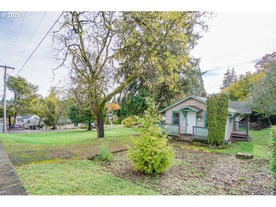
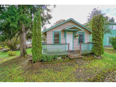

510 W 5th St La Center, WA 98629
Estimated payment $1,753/month
Highlights
- RV Access or Parking
- Wood Flooring
- No HOA
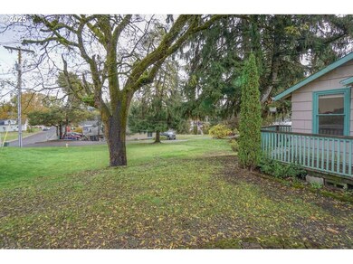
- Territorial View
- Corner Lot
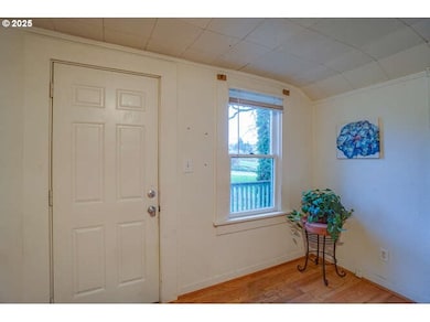
- Wood Frame Window
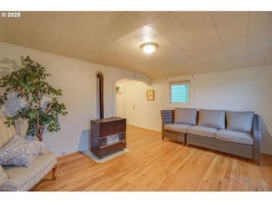
About This Home
Older 1 brm bungalow with basement garage & utility. Huge corner lot with room for a shop or another residence.Current zoning would allow 2 duplexs on this parcel. Needs lots of work to make it homey. More photos will be posted tomorrow.
Listing Agent
John L. Scott Real Estate Brokerage Phone: 360-936-6103 License #46006 Listed on: 11/01/2025

Home Details
Home Type
- Single Family
Est. Annual Taxes
- $2,079
Year Built
- Built in 1944
Lot Details
- 10,018 Sq Ft Lot
- Corner Lot
- Level Lot
- Property is zoned LDR 7.5
Parking
- 1 Car Attached Garage
- Tuck Under Garage
- Driveway
- RV Access or Parking
Home Design
- Bungalow
- Composition Roof
- Wood Siding
- Concrete Perimeter Foundation
Interior Spaces
- 944 Sq Ft Home
- 1-Story Property
- Wood Frame Window
- Family Room
- Living Room
- Dining Room
- Utility Room
- Washer and Dryer
- Territorial Views
- Free-Standing Range
- Unfinished Basement
Flooring
- Wood
- Laminate
- Vinyl
Bedrooms and Bathrooms
- 1 Bedroom
- 1 Full Bathroom
Outdoor Features
- Porch
Schools
- La Center Elementary And Middle School
- La Center High School
Utilities
- No Cooling
- Forced Air Heating System
- Heating System Uses Gas
- Electric Water Heater
Community Details
- No Home Owners Association
Listing and Financial Details
- Assessor Parcel Number 063600000
Map
Home Values in the Area
Average Home Value in this Area
Tax History
| Year | Tax Paid | Tax Assessment Tax Assessment Total Assessment is a certain percentage of the fair market value that is determined by local assessors to be the total taxable value of land and additions on the property. | Land | Improvement |
|---|---|---|---|---|
| 2025 | $2,184 | $241,256 | $146,796 | $94,460 |
| 2024 | $2,079 | $236,161 | $146,796 | $89,365 |
| 2023 | $1,945 | $233,933 | $142,520 | $91,413 |
| 2022 | $1,815 | $211,477 | $122,512 | $88,965 |
| 2021 | $1,759 | $175,243 | $98,010 | $77,233 |
| 2020 | $1,663 | $160,021 | $91,009 | $69,012 |
| 2019 | $1,556 | $148,025 | $81,908 | $66,117 |
| 2018 | $1,421 | $140,968 | $0 | $0 |
| 2017 | $1,163 | $127,297 | $0 | $0 |
| 2016 | $1,159 | $110,578 | $0 | $0 |
| 2015 | $1,120 | $102,566 | $0 | $0 |
| 2014 | -- | $94,793 | $0 | $0 |
| 2013 | -- | $86,861 | $0 | $0 |
Property History
| Date | Event | Price | List to Sale | Price per Sq Ft |
|---|---|---|---|---|
| 11/06/2025 11/06/25 | Pending | -- | -- | -- |
| 11/01/2025 11/01/25 | For Sale | $300,000 | -- | $318 / Sq Ft |
Purchase History
| Date | Type | Sale Price | Title Company |
|---|---|---|---|
| Interfamily Deed Transfer | -- | None Available | |
| Interfamily Deed Transfer | -- | None Available | |
| Warranty Deed | $62,000 | Stewart Title |
Source: Regional Multiple Listing Service (RMLS)
MLS Number: 448672460
APN: 063600-000
Disclaimer: Certain information contained herein is derived from information provided by parties other than Homes.com. All information provided is deemed reliable, but is not guaranteed to be accurate and should be independently verified.
![]() The content relating to real estate for sale on this web site comes in part from the IDX program of the RMLS™ of Portland, Oregon. Real estate listings held by brokerage firms other than Ten-X are marked with the RMLS™ logo, and detailed information about these properties includes the names of the listing brokers. Listing content is copyright © 2025 RMLS™, Portland, Oregon. Some properties which appear for sale on this web site may subsequently have sold or may no longer be available. All information provided is deemed reliable but is not guaranteed and should be independently verified.
The content relating to real estate for sale on this web site comes in part from the IDX program of the RMLS™ of Portland, Oregon. Real estate listings held by brokerage firms other than Ten-X are marked with the RMLS™ logo, and detailed information about these properties includes the names of the listing brokers. Listing content is copyright © 2025 RMLS™, Portland, Oregon. Some properties which appear for sale on this web site may subsequently have sold or may no longer be available. All information provided is deemed reliable but is not guaranteed and should be independently verified.
- 205 E Airedale Ave
- 1025 NW Pacific Hwy
- 135 E Airedale Ave
- 0000 NW 9th Ave
- 1202 W Avocet Place
- 124 W 12th Way
- 1003 E Southview Heights Dr
- 1503 W Alder Place
- 642 E Pioneer Loop
- 101 W 15th Cir
- 313 E Caribou Ct
- 313 E Caribou Ct Unit 24
- 1424 NW 11th St
- 1506 NW 339th St
- 790 E 15th Cir
- 1035 E Pioneer Loop
- 1300 W 15th Ave
- 120 W 19th St
- 409 W 19th St
- 403 W 19th St