511 E Liberty St Wauconda, IL 60084
Estimated Value: $323,000 - $462,000
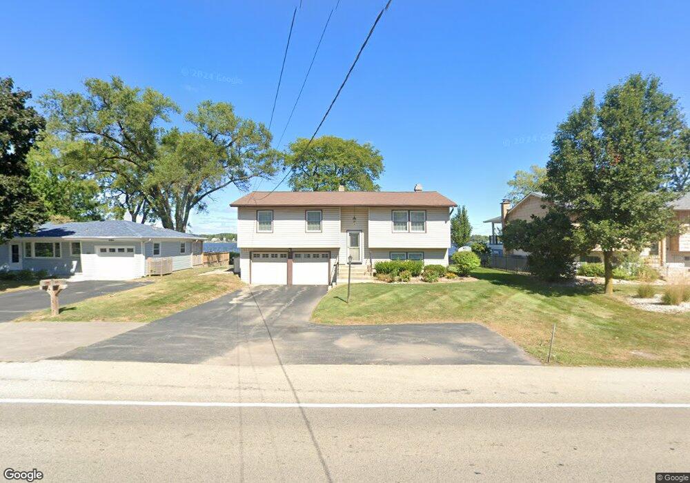
About This Home
This home is located at 511 E Liberty St, Wauconda, IL 60084 and is currently estimated at $408,058, approximately $335 per square foot. 511 E Liberty St is a home located in Lake County with nearby schools including Wauconda Grade School, Wauconda Middle School, and Wauconda High School.
Ownership History
We collect this data history from publicly available records. To have your information removed, we recommend requesting removal directly through your county’s website.
Purchase Details
Purchase Details
Home Financials for this Owner
Home Financials are based on the most recent Mortgage that was taken out on this home.Home Values in the Area
Average Home Value in this Area
Purchase History
We collect this data history from publicly available records. To have your information removed, we recommend requesting removal directly through your county’s website.
| Date | Buyer | Sale Price | Title Company |
|---|---|---|---|
| $238,000 | Chicago Title Insurance Comp | ||
| $110,000 | Land Title Group |
Mortgage History
We collect this data history from publicly available records. To have your information removed, we recommend requesting removal directly through your county’s website.
| Date | Status | Borrower | Loan Amount |
|---|---|---|---|
| Previous Owner | $115,000 |
Tax History
We collect this data history from publicly available records. To have your information removed, we recommend requesting removal directly through your county’s website.
| Year | Tax Paid | Tax Assessment Tax Assessment Total Assessment is a certain percentage of the fair market value that is determined by local assessors to be the total taxable value of land and additions on the property. | Land | Improvement |
|---|---|---|---|---|
| 2025 | $10,243 | $131,455 | $51,002 | $80,453 |
| 2024 | $10,274 | $123,143 | $47,777 | $75,366 |
| 2023 | $8,675 | $112,562 | $43,672 | $68,890 |
| 2022 | $8,675 | $85,502 | $26,837 | $58,665 |
| 2021 | $8,279 | $80,792 | $25,359 | $55,433 |
| 2020 | $8,012 | $77,004 | $24,170 | $52,834 |
| 2019 | $6,889 | $72,776 | $22,843 | $49,933 |
| 2018 | $7,929 | $74,901 | $27,086 | $47,815 |
| 2017 | $7,737 | $74,035 | $26,773 | $47,262 |
| 2016 | $7,208 | $70,109 | $25,353 | $44,756 |
| 2015 | $6,768 | $62,602 | $23,276 | $39,326 |
| 2014 | $6,234 | $58,338 | $21,690 | $36,648 |
| 2012 | $6,081 | $59,389 | $22,081 | $37,308 |
Map
- 414 E Liberty St
- 25586 W High St
- 25578 W High St
- 25570 W High St
- 211 E Liberty St Unit 4
- 213 E Liberty St Unit 11
- 345 Sundown Ct Unit B
- 221 Sky Hill Rd
- 150 E Mill St
- 365 Lake Ave Unit C
- 304 Hill St Unit 1004
- 325 Stillwater Ct Unit 1305
- 330 Stillwater Ct Unit 1504
- 229 Wethington Dr
- 428 Country Lane Ct Unit 301
- 124 Hubbard Ct
- 605 Lake Shore Blvd
- 820 Peninsula Dr
- 214 Minerva Ave
- 980 Peninsula Dr
- 515 E Liberty St
- 525 E Liberty St
- 427 E Liberty St
- 506 E Liberty St
- 504 E Liberty St
- 425 E Liberty St
- 500 E Liberty St
- 510 E Liberty St
- 522 E Liberty St
- 423 E Liberty St
- 426 E Liberty St
- 524 E Liberty St
- 422 E Liberty St
- 605 E Liberty St
- 419 E Liberty St
- 420 E Liberty St
- 609 E Liberty St
- 415 E Liberty St
- 113 Ridge St
- 604 E Liberty St
Ask me questions while you tour the home.