


511 Kirkwood Blvd Davenport, IA 52803
Central Davenport NeighborhoodEstimated payment $1,611/month
Highlights
- 1 Fireplace
- Guest Parking
- Level Lot
- Enclosed Patio or Porch
- Fenced
About This Home
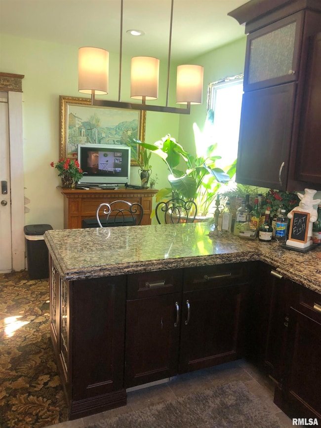
COMING SOON This home is a true classic. From the moment you walk through the door, you're embraced by its grand and timeless character. Located at 511 Kirkwood, this residence has seen numerous quality updates over the past several years, blending historic charm with modern comfort. Recent improvements include new windows, an efficient boiler for even heat distribution—perfect for staying cozy during colder months. The home was professionally leveled with new support beams in the basement. In 2025, the roof was replaced and the exterior received a fresh coat of paint. Inside, the original plaster walls have been repaired and freshly painted, and the main bathroom on the second floor has been completely remodeled. The gourmet kitchen, completed just two years ago, features high-end finishes that will impress any home chef. Enjoy peaceful mornings or relaxed evenings on the three-season porch, or bring your chairs to the boulevard's edge to take in the excitement of the Bix 7. This is a rare opportunity to own a beautifully updated, character-filled home in a truly special location. Owner is a licensed Realtor in Iowa.
Listing Agent
Ruhl&Ruhl REALTORS Bettendorf Brokerage Phone: 563-441-1776 License #S62558000/475203758 Listed on: 12/01/2025

Co-Listing Agent
Ruhl&Ruhl REALTORS Bettendorf Brokerage Phone: 563-441-1776 License #S66198000
Home Details
Home Type
- Single Family
Est. Annual Taxes
- $2,602
Year Built
- Built in 1900
Lot Details
- 5,663 Sq Ft Lot
- Lot Dimensions are 80 x 73
- Fenced
- Level Lot
Home Design
- Shingle Roof
- Aluminum Siding
Interior Spaces
- 2,200 Sq Ft Home
- 1 Fireplace
- Basement Fills Entire Space Under The House
Kitchen
- Range
- Microwave
- Dishwasher
Bedrooms and Bathrooms
- 4 Bedrooms
- 2 Full Bathrooms
Parking
- Carport
- Guest Parking
Outdoor Features
- Enclosed Patio or Porch
Schools
- Davenport Elementary And Middle School
- Davenport Central High School
Utilities
- Window Unit Heating System
- Heating System Uses Natural Gas
- Gas Water Heater
Community Details
- Leclaire Kirkwood Subdivision
Listing and Financial Details
- Assessor Parcel Number F0015-01
Map
Home Values in the Area
Average Home Value in this Area
Tax History
| Year | Tax Paid | Tax Assessment Tax Assessment Total Assessment is a certain percentage of the fair market value that is determined by local assessors to be the total taxable value of land and additions on the property. | Land | Improvement |
|---|---|---|---|---|
| 2025 | $2,602 | $145,580 | $19,320 | $126,260 |
| 2024 | $2,538 | $145,580 | $19,320 | $126,260 |
| 2023 | $2,480 | $145,580 | $19,320 | $126,260 |
| 2022 | $2,492 | $116,120 | $10,490 | $105,630 |
| 2021 | $2,492 | $116,120 | $10,490 | $105,630 |
| 2020 | $2,224 | $102,340 | $10,490 | $91,850 |
| 2019 | $2,296 | $102,340 | $10,490 | $91,850 |
| 2018 | $459 | $102,340 | $10,490 | $91,850 |
| 2017 | $544 | $97,750 | $10,490 | $87,260 |
| 2016 | $2,865 | $97,750 | $0 | $0 |
| 2015 | $2,140 | $95,920 | $0 | $0 |
| 2014 | $2,130 | $96,900 | $0 | $0 |
| 2013 | $2,114 | $0 | $0 | $0 |
| 2012 | -- | $102,460 | $14,730 | $87,730 |
Property History
| Date | Event | Price | List to Sale | Price per Sq Ft |
|---|---|---|---|---|
| 12/01/2025 12/01/25 | For Sale | $265,000 | -- | $120 / Sq Ft |
Purchase History
| Date | Type | Sale Price | Title Company |
|---|---|---|---|
| Contract Of Sale | $105,000 | None Available |
Mortgage History
| Date | Status | Loan Amount | Loan Type |
|---|---|---|---|
| Closed | $95,000 | Seller Take Back |
Source: RMLS Alliance
MLS Number: QC4269590
APN: F0015-01
Disclaimer: Certain information contained herein is derived from information provided by parties other than Homes.com. All information provided is deemed reliable, but is not guaranteed to be accurate and should be independently verified.
![]() IDX information is provided exclusively for personal, non-commercial use, and may not be used for any purpose other than to identify prospective properties consumers may be interested in purchasing. Information is deemed reliable but not guaranteed.
IDX information is provided exclusively for personal, non-commercial use, and may not be used for any purpose other than to identify prospective properties consumers may be interested in purchasing. Information is deemed reliable but not guaranteed.
- 420 Kirkwood Blvd
- 325 Kirkwood Blvd
- 618 Douglas Ct
- 637 E 15th St
- 409 E 14th St
- 320 E 14th St
- 407 E 14th St
- 1812 Pershing Ave
- 1215 Farnam St
- 1603 Arlington Ave
- 1605 Arlington Ave
- 1222 Pershing Ave
- 209 E 13th St
- 125 E Locust St
- 625 E High St
- 11 Oak Ln
- 1020 E 15th St
- 1108 Arlington Ave
- 1518 N Main St
- 1920 Carey Ave
- 1015 Arlington Ct
- 505 E Rusholme St Unit Lower
- 1318 N Main St Unit 2
- 1420 N Harrison St
- 1206 Bridge Ave Unit 2
- 1115 Oneida Ave
- 2330 Grand Ave
- 1203 E 11th St
- 529 E 7th St
- 321 E 7th St
- 818 Charlotte St
- 1211 E 9th St Unit 1
- 2608 Leclaire St Unit Main
- 2608 Leclaire St
- 1207 E 9th St Unit 1
- 2615 Davenport Ave Unit Apartment 1
- 511 Pershing Ave
- 736 Federal St
- 500 Iowa St
- 427 Pershing Ave