
Seller's Agent in 2025
Mike Azzam
RE/MAX
(216) 456-3855
210 in this area
1,934 Total Sales

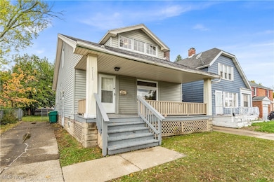
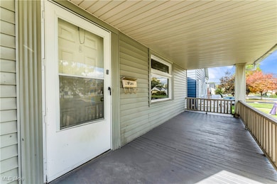
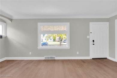
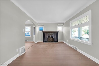
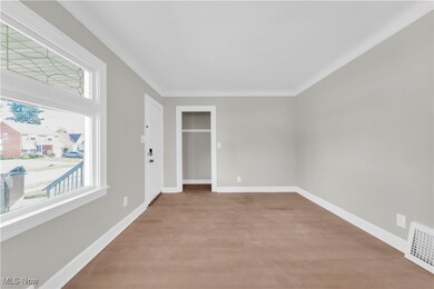
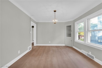
Here's your chance to become a real estate investor overnight! Solid single-family bungalow with 4 bedrooms and 1 full bathroom—2 bedrooms and the bathroom on the main level, plus 2 bedrooms upstairs! Featuring vinyl siding, newer furnace, newer water heater, updated electric panel, and a newer roof, this home is ready for investors to add value. Recently refreshed with freshly painted interior and new LVP flooring throughout, it’s fully compliant and violation-free for city rental regulations. Needs at least a rent-ready update, making it perfect for investors looking to maximize returns. Professional management is in place and willing to stay on, offering full-service support for leasing, marketing, tenant communication, and even rehab and construction services—ideal for remote investors! Centrally located in a highly desirable area with easy access to highways, close proximity to Garfield Park Reservation, shopping, restaurants, and public transit, this property combines convenience and strong rental demand. A must-add to any rental portfolio—this won’t last long! Schedule a showing to see it for yourself!
Last Agent to Sell the Property
RE/MAX Haven Realty Brokerage Email: mike@theazzamgroup.com, 216-232-2187 License #2014004734 Listed on: 07/15/2025
| Date | Type | Sale Price | Title Company |
|---|---|---|---|
| Warranty Deed | $110,000 | Csc Document Recording (Record | |
| Warranty Deed | $34,500 | Ohio Title Corp | |
| Quit Claim Deed | -- | None Available | |
| Limited Warranty Deed | $9,500 | New Market Title | |
| Sheriffs Deed | $16,117 | None Available | |
| Deed | $20,000 | -- | |
| Deed | -- | -- | |
| Deed | -- | -- |
| Date | Event | Price | List to Sale | Price per Sq Ft |
|---|---|---|---|---|
| 12/05/2025 12/05/25 | Sold | $110,000 | -11.9% | $121 / Sq Ft |
| 11/16/2025 11/16/25 | Pending | -- | -- | -- |
| 10/14/2025 10/14/25 | Price Changed | $124,900 | 0.0% | $137 / Sq Ft |
| 10/14/2025 10/14/25 | For Sale | $124,900 | +13.5% | $137 / Sq Ft |
| 07/25/2025 07/25/25 | Off Market | $110,000 | -- | -- |
| 07/15/2025 07/15/25 | Pending | -- | -- | -- |
| 07/15/2025 07/15/25 | For Sale | $99,000 | -- | $109 / Sq Ft |
| Year | Tax Paid | Tax Assessment Tax Assessment Total Assessment is a certain percentage of the fair market value that is determined by local assessors to be the total taxable value of land and additions on the property. | Land | Improvement |
|---|---|---|---|---|
| 2024 | $3,092 | $33,250 | $7,140 | $26,110 |
| 2023 | $1,984 | $17,470 | $4,340 | $13,130 |
| 2022 | $1,977 | $17,465 | $4,340 | $13,125 |
| 2021 | $2,104 | $17,470 | $4,340 | $13,130 |
| 2020 | $1,807 | $13,230 | $3,290 | $9,940 |
| 2019 | $1,797 | $37,800 | $9,400 | $28,400 |
| 2018 | $893 | $13,230 | $3,290 | $9,940 |
| 2017 | $1,777 | $12,850 | $3,010 | $9,840 |
| 2016 | $1,719 | $12,850 | $3,010 | $9,840 |
| 2015 | $1,710 | $12,850 | $3,010 | $9,840 |
| 2014 | $1,710 | $14,110 | $3,330 | $10,780 |
Seller's Agent in 2025
Mike Azzam
RE/MAX
(216) 456-3855
210 in this area
1,934 Total Sales
L
Buyer's Agent in 2025
Leanne Saffer
Keller Williams Citywide
(440) 321-5602
7 in this area
106 Total Sales
Source: MLS Now
MLS Number: 5140451
APN: 781-27-047
Disclaimer: Certain information contained herein is derived from information provided by parties other than Homes.com. All information provided is deemed reliable, but is not guaranteed to be accurate and should be independently verified.
![]() IDX information is provided exclusively for personal, non-commercial use, and may not be used for any purpose other than to identify prospective properties consumers may be interested in purchasing. Information is deemed reliable but not guaranteed.
IDX information is provided exclusively for personal, non-commercial use, and may not be used for any purpose other than to identify prospective properties consumers may be interested in purchasing. Information is deemed reliable but not guaranteed.
Ask me questions while you tour the home.